Ludwigs Corner, Pennsylvania

Last updated

Ludwigs Corner, Pennsylvania
LudwigsCorner.jpg
Ludwigs Corner lies the intersection of PA Route 100 and PA Route 401 in Chester County, Pennsylvania.
USA Pennsylvania location map.svg
Red pog.svg
Ludwigs Corner
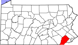
Location of Ludwigs Corner in Pennsylvania
Usa edcp location map.svg
Red pog.svg
Ludwigs Corner
Ludwigs Corner (the United States)
Coordinates: 40°06′56″N75°41′38″W / 40.11556°N 75.69389°W / 40.11556; -75.69389
CountryUnited States
StatePennsylvania
County Chester
Township West Vincent
Elevation
627 ft (191 m)
Time zone UTC-5 (EST)
  Summer (DST) UTC-4 (EDT)
Area code(s) 610

Ludwigs Corner is an unincorporated village located in West Vincent Township, Pennsylvania, United States. It is four miles north of Eagle.

Contents

Geography

Ludwigs Corner is a community in Chester County, Pennsylvania, located at latitude 40.116 and longitude -75.694 with an elevation of 627 feet.

Transportation

Ludwigs Corner is located at the junction of PA Route 100 and PA Route 401.

Pennsylvania Route 401 is also known as Conestoga Road. In the colonial era, this route was known as the Conestoga Turnpike and was a main path of travel between Philadelphia and western towns such as Lancaster. Many of the wagons were of a flat but arched design that would float when fording creeks and rivers with high water. They were known as Conestoga wagons.

History

Ludwigs Corner is the home of St. Andrews Episcopal Church, organized in 1832. Within the walled cemetery is the grave of Owen Josephus Roberts, United States Supreme Court Justice from 1930 - 1945.

Ludwigs Corner is known for being the host of the annual Ludwig's Corner Horse Show & Country Fair held over Labor Day Weekend. [1]

Notes

  1. "Home". ludwigshorseshow.com.

Related Research Articles

<span class="mw-page-title-main">Lancaster County, Pennsylvania</span> County in Pennsylvania, United States

Lancaster County, sometimes nicknamed the Garden Spot of America or Pennsylvania Dutch Country, is a county in the Commonwealth of Pennsylvania. It is located in the south central part of Pennsylvania. As of the 2020 census, the population was 552,984, making it Pennsylvania's sixth-most populous county. Its county seat is Lancaster. Lancaster County comprises the Lancaster, Pennsylvania metropolitan statistical area.

<span class="mw-page-title-main">Willow Street, Pennsylvania</span> Census-designated place in Pennsylvania, United States

Willow Street is an unincorporated community and census-designated place (CDP) in Lancaster County, Pennsylvania, United States. The population was 7,578 at the 2010 census. In the early part of the 20th century, the main thoroughfare in town was lined with willow trees on both sides for the length of the town, hence the community's name. As time passed and the town grew, the road was widened and sidewalks were installed, which required the trees be removed. Only a few of the original trees remain to this day.

<span class="mw-page-title-main">Caernarvon Township, Berks County, Pennsylvania</span> Township in Pennsylvania, United States

Caernarvon Township is a township in Berks County, Pennsylvania, United States. The population was 4,252 at the 2020 census. It is often referred to as Morgantown, the township's largest village.

<span class="mw-page-title-main">New Morgan, Pennsylvania</span> Borough in Berks County, Pennsylvania, United States

New Morgan is a borough in Berks County, Pennsylvania, United States. The population was 71 at the 2010 census.

<span class="mw-page-title-main">Elverson, Pennsylvania</span> Borough in Pennsylvania, United States

Elverson is a borough in Chester County, Pennsylvania, United States. The population was 1,332 at the 2020 census.

<span class="mw-page-title-main">Upper Uwchlan Township, Pennsylvania</span> Township in Pennsylvania, United States

Upper Uwchlan Township is a township in Chester County, Pennsylvania, United States. The population was 11,227 at the 2010 census. The township included the community of Milford Mills before it was inundated by the creation of the Marsh Creek Dam in 1972.

<span class="mw-page-title-main">West Nantmeal Township, Pennsylvania</span> Township in Pennsylvania, United States

West Nantmeal Township is a township in Chester County, Pennsylvania, United States. The population was 2,170 at the 2010 census. It and East Nantmeal Township were originally part of a single Nantmeal Township, which was divided in 1739.

<span class="mw-page-title-main">West Vincent Township, Pennsylvania</span> Township in Pennsylvania, United States

West Vincent Township is a township in Chester County, Pennsylvania, United States. The population was 4,567 at the 2010 census.

<span class="mw-page-title-main">Kittanning Gap</span>

Kittanning Gap, one of the gaps of the Allegheny, is a now a relatively unimportant wooded ravine along the ascent of the Allegheny Ridge (also called the 'Allegheny Front' or 'Allegheny escarpment') in central Pennsylvania in the United States. The gap was one of several optional paths of the Kittanning Path Amerindian trail turned into an emigrant route over the Alleghenies in the day of animal powered technology. The option up the gap was likely the 'better choice' of an ascending route for ox cart and wagon encumbered white settlers pouring west across the Alleghenies escarpment.

<span class="mw-page-title-main">Conestoga wagon</span> Type of heavy covered wagon

The Conestoga wagon is a specific design of heavy covered wagon that was used extensively during the late eighteenth century, and the nineteenth century, in the eastern United States and Canada. It was large enough to transport loads up to six short tons, and was drawn by horses, mules, or oxen. It was designed to help keep its contents from moving about when in motion and to aid it in crossing rivers and streams, though it sometimes leaked unless caulked.

Conestoga originally referred to the Conestoga people, an English name for the Susquehannock people of Pennsylvania.

<span class="mw-page-title-main">Conestoga River</span> River

The Conestoga River, also referred to as Conestoga Creek, is a 61.6-mile-long (99.1 km) tributary of the Susquehanna River flowing through the center of Lancaster County, Pennsylvania, United States.

<span class="mw-page-title-main">Blue Ball, Pennsylvania</span> Census-designated place in Pennsylvania, United States

Blue Ball is an unincorporated community and census-designated place (CDP) in East Earl Township, Lancaster County, Pennsylvania, United States. Blue Ball lies approximately 2 miles (3 km) east-northeast of the borough of New Holland at the intersection of US 322 and PA Route 23. As of the 2010 census, the population was 1,031.

<span class="mw-page-title-main">Transportation in Lancaster County, Pennsylvania</span>

Transportation in Lancaster County, Pennsylvania has a long and variegated history. An early-settled part of the United States, and lying on the route between Philadelphia and Harrisburg, it has been the site of early experiments in canals, railroads, and highways. Before all these, at least ten Native American paths crossed parts of the county, many connecting with the Susquehannock village of Conestoga.

<span class="mw-page-title-main">Pennsylvania Route 23</span> State highway in Pennsylvania, US

Pennsylvania Route 23 is an 81.14-mile-long (130.58 km) state highway in southeastern Pennsylvania. The route begins at PA 441 in Marietta and heads east to U.S. Route 1 at City Avenue on the border of Lower Merion Township and Philadelphia. PA 23 begins at Marietta in Lancaster County and continues east to Lancaster, where it passes through the city on a one-way pair of streets and intersects US 222 and US 30.

<span class="mw-page-title-main">Pennsylvania Route 401</span> State highway in Pennsylvania, US

Pennsylvania Route 401 is a 20.2-mile-long (32.5 km) east–west state route in Berks and Chester counties, located in southeast Pennsylvania. The western terminus is at PA 23 in Caernarvon Township, across the county line from Elverson. The eastern terminus is at U.S. Route 30 in East Whiteland Township, a short distance west of Malvern. PA 401 is called Conestoga Road its entire length and runs through rural areas with suburban development toward the eastern part of the route. PA 401 follows a former turnpike chartered in 1809 known as the Little Conestoga Turnpike. PA 401 was designated along Conestoga Road between PA 29 and US 30/PA 1 in 1928. The route was extended west to PA 23 in the 1930s, at which time the entire length was paved.

<span class="mw-page-title-main">Smoketown, Pennsylvania</span> Census-designated place in Pennsylvania, United States

Smoketown is an unincorporated village and census-designated place (CDP) in East Lampeter Township, Lancaster County, Pennsylvania, United States. Also known as Smoke Town, it is served by the Smoketown Airport. As of the 2010 census, it had a population of 357.

<span class="mw-page-title-main">Eagle, Pennsylvania</span> Census-designated place in Pennsylvania, United States

Eagle is an unincorporated community and census-designated place in Upper Uwchlan Township, Chester County, Pennsylvania, United States. As of 2020, Eagle had a population of 498.

<span class="mw-page-title-main">Upper Strasburg, Pennsylvania</span> Unincorporated community in Pennsylvania, United States

Upper Strasburg is an unincorporated community that is located in Letterkenny Township in Franklin County, Pennsylvania, United States.

Conestoga Road, also called "Conestoga Pike" or "Allegheny Path", is a historic road dating from at least 1684 in what is now the U.S. state of Pennsylvania. It starts as Allegheny Avenue in Philadelphia to the west through Morgantown, Harrisburg and west towards the Allegheny Valley. Originally the road was a walking path that was 12-18 inches in width. During the era of horse drawn Conestoga wagons, the road was widened. During most of its existence as a turnpike, it served as the alternate route to the Lancaster Pike and Ridge Road. The route gained notoriety as the shortest route from Philadelphia to Harrisburg.