
Potter is a town in Yates County, New York, United States. The Town of Potter is located in the northwest part of the county and is south of Canandaigua. The population was 1,865 at the 2010 census.
Birmingham Township is a township in Chester County, Pennsylvania, United States. The population was 4,085 at the 2020 census.
East Fallowfield Township is a township in Chester County, Pennsylvania, United States. The population was 7,626 at the 2020 census.
West Bradford Township is a township that is located in Chester County, Pennsylvania, United States. The population was 12,376 at the time of the 2010 census.

Concord Township is a township in Delaware County, Pennsylvania, United States. The population was 17,231 at the 2010 census. It contains the unincorporated communities of Concordville and Glen Mills.
Thornbury Township is a township in Delaware County, Pennsylvania, United States. As of the 2010 U.S. census, the population was 8,028, up from 7,093 at the 2000 census. It is adjacent to, and was once joined with, Thornbury Township in Chester County. It includes part of the census designated place of Cheyney University.

Brandywine Creek is a tributary of the Christina River in southeastern Pennsylvania and northern Delaware in the United States. The Lower Brandywine is 20.4 miles (32.8 km) long and is a designated Pennsylvania Scenic River with several tributary streams. The East Branch and West Branch of the creek originate within 2 miles (3 km) of each other on the slopes of Welsh Mountain in Honey Brook Township, Pennsylvania, about 20 miles (32 km) northwest of their confluence.
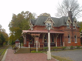
Glen Mills is an unincorporated community in Concord Township, Delaware County, Pennsylvania, United States, located approximately 27 miles west of Philadelphia. The ZIP Code for Glen Mills is 19342.

Cheyney is an unincorporated community that sits astride Chester and Delaware counties in the U.S. state of Pennsylvania. It corresponds to the census-designated place known as Cheyney University, which had a population of 988 at the 2010 census. It is the home of Cheyney University of Pennsylvania. The university derives its name from George Cheyney's Farm, which became the current campus of Cheyney University in 1902. George Cheyney's Farm and the surrounding area was part of the original land grant given to William Penn in 1681.
Pennsylvania Route 82 is a 32-mile-long (51 km) north–south state highway located in Chester County in southeast Pennsylvania, USA. The southern terminus is at the Delaware state line southeast of Kennett Square, where the road continues south into that state as Delaware Route 82. The northern terminus is at PA 23 in Elverson. PA 82 heads through rural areas of Chester County along with the communities of Kennett Square, Unionville, and Coatesville. The route intersects many important roads including U.S. Route 1 near Kennett Square, PA 162 and PA 842 in Unionville, US 30 in Coatesville, and US 322 in Brandywine Manor. PA 82 is a two-lane undivided road most of its length.

Pennsylvania Route 162 is a 10.1-mile-long (16.3 km) state highway in southeast Pennsylvania. The western terminus of the route is at PA 82/PA 842 in Unionville, Chester County. The eastern terminus is at U.S. Route 322 Business in West Chester. PA 162 is known as Embreeville Road from its western terminus to the village of Embreeville and Telegraph Road from Embreeville to an intersection with Strasburg Road west of Marshallton. At this point, the route turns east, following Strasburg Road to US 322 Bus. in West Chester. The portion of road between Marshallton and West Chester follows the 17th-century Great Minquas Path and became part of the Strasburg Road linking Strasburg and Philadelphia in the 1770s. PA 162 was designated onto its current alignment by 1930.
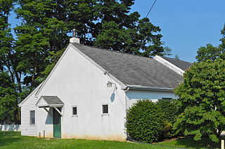
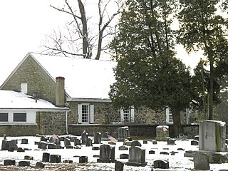
Ercildoun, population about 100, is an unincorporated community in East Fallowfield Township, Chester County, Pennsylvania, United States. The hamlet was founded by Quakers and was an early center of the abolitionist movement. In 1985 the entire hamlet, including 31 properties, was listed as a historic district on the National Register of Historic Places. Of these properties two were vacant land, 14 were significant buildings, ten were contributing buildings, and five buildings, built in the 1950s, were non-contributing. The Lukens Pierce House, an octagon house listed separately on the U.S. National Register of Historic Places, is located about half a mile northwest of the hamlet. Ercildoun is one of about ten hamlets in the township, which has no cities or towns, but has 31 sites listed on the National Register. It is one of the larger hamlets, located near the center of the township, and historically among the best known. The city of Coatesville is about 3 miles north.

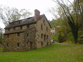
The Newlin Mill Complex, also referred to as The Newlin Grist Mill, is a water-powered gristmill on the west branch of Chester Creek near Concordville, Pennsylvania built in 1704 by Nathaniel and Mary Newlin and operated commercially until 1941. During its three centuries of operation, the mill has been known as the Lower Mill, the Markham Mill, the Seventeen-O-Four Mill and the Concord Flour Mill. In 1958 the mill property was bought by E. Mortimer Newlin, restored and given to the Nicholas Newlin Foundation to use as a historical park. Water power is still used to grind corn meal which is sold on site. The park includes five historical buildings, which were added to the National Register of Historic Places in 1983, and 150 acres (61 ha) of natural woodland.
Potterstown is an unincorporated community along the border of Clinton and Readington townships in Hunterdon County, New Jersey.

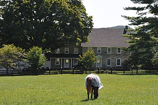
The Sourlands is a region in the central portion of the U.S. state of New Jersey that includes portions of Hunterdon County, Mercer County, and Somerset County. It is centered on Sourland Mountain and comprises parts of Lambertville, East Amwell, West Amwell, Hillsborough, Hopewell Boro, Hopewell Township, and Montgomery Township. The region is flanked by the Hopewell Fault to the south and Amwell Valley to the north that runs from Mount Airy to an area just west of Flagtown and a diabase formation running from Lambertville to Mount Airy. The Sourland also include a hilly area towards the southwest called Pleasant Valley, with a number of farms. Although much of the Sourlands is not conducive to farming, Pleasant Valley and the slopes on the surrounding ridges have a number of farms. The slopes of the ridge to the north are also home to Unionville Vineyard.

Strasburg Road was an early road in Pennsylvania connecting Philadelphia to Strasburg in Lancaster County. The route was surveyed by John Sellers and others in 1772-3 under the colonial administration of Governor Richard Penn and completed under the new administration of the independent state of Pennsylvania. The route started at the "second ferry" on the Schuylkill River, today's Market Street in Philadelphia, and went through West Chester, East Fallowfield Township, and Gap, before ending in Strasburg. Earlier roads travelled much the same route, including a Native American path in use as early as 1620.
Bridge in East Fallowfield Township may refer to:
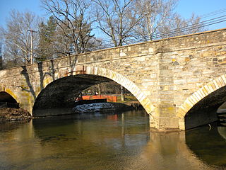
Cope's Bridge is a stone arch bridge that carries Strasburg Road across the East Branch Brandywine Creek in East Bradford Township, Chester County, Pennsylvania. The bridge is listed on the National Register of Historic Places and is located within the Taylor–Cope Historic District.

The Mortonville Bridge and Mill Race Bridge are stone arch bridges carrying Strasburg Road across the West Branch Brandywine Creek and an abandoned millrace at Mortonville, Pennsylvania. The Mortonville Bridge was placed on the National Register of Historic Places on September 18, 1985, while the Mill Race Bridge was added as the Bridge in East Fallowfield Township on June 22, 1988. The Mortonville Bridge was removed from the Register on July 16, 2010, following reconstruction; the Mill Race Bridge remains registered.

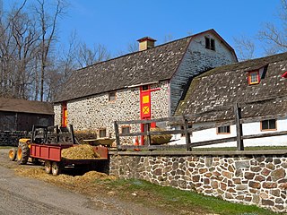
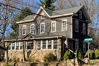
Embreeville Historic District is a national historic district located in Newlin Township, Chester County, Pennsylvania. It encompasses 12 contributing buildings along the east and west banks of the West Branch Brandywine Creek in the village of Embreeville. It includes a variety of vernacular, banked, stuccoed stone buildings. They were largely built between about 1822 and 1842, with the earliest house built about 1760. The buildings include a farmhouse, a country store, a storekeeper's house, a blacksmith's house, a wheelwright's house and store, a grist mill known as the Embreeville Mill, a "mansion" (1856), and miller's house.


