The Bitzer's Mill Covered Bridge is a covered bridge that spans the Conestoga River in Lancaster County, Pennsylvania, United States. It is the oldest bridge in the county still in use. A county-owned and maintained bridge, its official designation is the Big Conestoga #2 Bridge. The bridge is also called Martin's Mill Bridge, Eberly's Cider Mill Covered Bridge, and Fiand's/Fiantz's Covered Bridge.

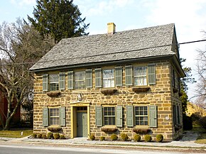
Strasburg is a borough in Lancaster County, Pennsylvania, United States. It developed as a linear village stretching approximately 2 miles (3 km) along the Great Conestoga Road, later known as the Strasburg Road. The population was 3,117 at the 2020 census.
Newport is a town in New Castle County, Delaware, United States. It is on the Christina River. It is best known for being the home of colonial inventor Oliver Evans. The population was 1,055 at the 2010 census. Four limited access highways, I-95, I-295, I-495, and Delaware Route 141 intersect within one mile (1.6 km) of the town.
Atglen is a borough in Chester County, Pennsylvania, United States. According to the 2020 census, its population is 1,311.

Parkesburg is a borough in Chester County, Pennsylvania, United States. The population was counted as 3,866 at the 2020 census. The ZIP code is 19365.

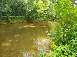
The Conestoga River, also referred to as Conestoga Creek, is a 61.6-mile-long (99.1 km) tributary of the Susquehanna River flowing through the center of Lancaster County, Pennsylvania, United States.

The Strasburg Rail Road is a heritage railroad and the oldest continuously operating standard-gauge railroad in the western hemisphere, as well as the oldest public utility in the Commonwealth of Pennsylvania. Chartered in 1832, the Strasburg Rail Road Company is today a heritage railroad offering excursion trains hauled by steam locomotives on 4.02 mi (6.47 km) of track in Pennsylvania Dutch Country, as well as providing contract railroad mechanical services, and freight service to area shippers. The railroad's headquarters are outside Strasburg, Pennsylvania.

The Mason-Dixon Trail is a 193-mile (311 km) hiking trail that begins at the Appalachian Trail in south-central Pennsylvania, continues through northeastern Maryland and northern Delaware, and re-enters Pennsylvania shortly before ending at Chadds Ford. It is named for the historic Mason–Dixon line, which it crosses twice. About one-third of the route follows roads through rural areas, but the rest is on traditional footpaths. The trail also traverses many tracts of private land, at which passage for hikers has been arranged with owners. This results in occasional relocations. The trail takes hikers through a variety or rural and semi-urban landscapes, with most of the route in Pennsylvania featuring farmlands and forested areas, and most of the route in Maryland and Delaware featuring historic sites and small towns.
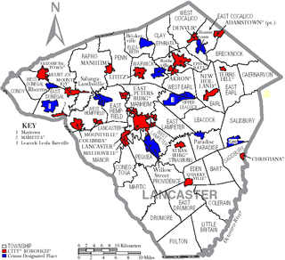
Transportation in Lancaster County, Pennsylvania has a long and variegated history. An early-settled part of the United States, and lying on the route between Philadelphia and Harrisburg, it has been the site of early experiments in canals, railroads, and highways. Before all these, at least ten Native American paths crossed parts of the county, many connecting with the Susquehannock village of Conestoga.

Pennsylvania Route 10 is a 44.04-mile-long (70.88 km) state route in southeastern Pennsylvania. Its southern terminus is at PA 472 in Oxford. Its northern terminus is at U.S. Route 222 Business in Reading. PA 10 is mostly a two-lane undivided road that serves Chester, Lancaster, and Berks counties. The route begins in Oxford and passes through rural areas of western Chester County, serving Cochranville, Parkesburg, Compass, and Honey Brook. The route passes through a small corner of eastern Lancaster County before it enters Berks County and reaches Morgantown, where it has interchanges with Interstate 176 (I-176) and the Pennsylvania Turnpike (I-76). Between Morgantown and Reading, PA 10 parallels I-176.

Pennsylvania Route 372 is an east–west highway in York, Lancaster, and Chester counties in the U.S. state of Pennsylvania. Its western terminus is at PA 74 in Lower Chanceford Township north of Delta and west of Holtwood, and its eastern terminus is at PA 82 in Coatesville. PA 372 heads east from PA 74 in York County and crosses the Susquehanna River on the Norman Wood Bridge. The route continues through Lancaster County, intersecting PA 272 in Buck, U.S. Route 222 and PA 472 in Quarryville, and PA 896 in Georgetown. PA 372 crosses into Chester County and intersects PA 41 in Atglen and PA 10 in Parkesburg before continuing to Coatesville. PA 372 is a two-lane undivided road throughout its length.

The Horse-Shoe Trail is a 140-mile (230 km) hiking and horseback riding trail in southeastern Pennsylvania, United States. It begins at Valley Forge National Park and ends at a junction with the Appalachian Trail near Harrisburg. Most of the trail is in an agricultural region with gently rolling topography, where it generally follows rural roads and old country lanes, but the western end is much more mountainous and rugged. A 17-mile segment of the trail in Chester and Berks counties has been designated as a National Recreation Trail.

Pennsylvania Route 741 is a 26.3-mile-long (42.3 km) state highway that runs through western and southern Lancaster County in the U.S. state of Pennsylvania. The western terminus is along Rohrerstown Road north of an intersection with Commercial Avenue near East Petersburg. The eastern terminus is at PA 41 in Gap. PA 741 heads south from East Petersburg and runs through the western suburbs of Lancaster. The route turns southeast and passes through Millersville before it turns east at New Danville. PA 741 forms a concurrency with U.S. Route 222 between Willow Street and Lampeter before it continues east through farmland in the Pennsylvania Dutch Country that is home to several Amish families, passing through Strasburg before reaching Gap.

Pennsylvania Route 162 is a 10.1-mile-long (16.3 km) state highway in southeast Pennsylvania. The western terminus of the route is at PA 82/PA 842 in Unionville, Chester County. The eastern terminus is at U.S. Route 322 Business in West Chester. PA 162 is known as Embreeville Road from its western terminus to the village of Embreeville and Telegraph Road from Embreeville to an intersection with Strasburg Road west of Marshallton. At this point, the route turns east, following Strasburg Road to US 322 Bus. in West Chester. The portion of road between Marshallton and West Chester follows the 17th-century Great Minquas Path and became part of the Strasburg Road linking Strasburg and Philadelphia in the 1770s. PA 162 was designated onto its current alignment by 1930.
The Great Valley is a west-to-east valley through the center of Chester County, Pennsylvania, United States. It is also sometimes referred to as Chester Valley, and both names are in use throughout the region. The valley stretches from the Schuylkill River in Montgomery County in the east, southwesterly through Chester and Lancaster counties. The valley is most distinct in central Chester County, although traces of it can be followed almost the entire distance between the Delaware and Susquehanna rivers.

Mortonville is an unincorporated area and historic hamlet in Chester County, Pennsylvania, United States, situated on the eastern bank of the West Branch Brandywine Creek. It consists of approximately one-half dozen structures, two of which are on the National Register of Historic Places: the Mortonville Hotel, and the 12.5-foot-long (3.8 m) "Bridge in East Fallowfield Township" which crosses a mill race a few feet east of a larger bridge. The larger bridge, known as the Mortonville Bridge, was also listed on the NRHP until 2010, when it was delisted following a renovation. The two bridges are in East Fallowfield Township, while most other structures are in Newlin Township.

Great Minquas Path was a 17th-century trade route that ran through southeastern Pennsylvania from the Susquehanna River, near Conestoga, to the Schuylkill River, opposite Philadelphia. The 80-mile (130 km) east-west trail was the primary route for fur trading with the Minquas people. Dutch, Swedish and English settlers fought one another for control of it.
The Conestoga Trail System is a 65.8-mile (105.9 km) linear hiking trail in Lancaster County, Pennsylvania. The system connects several relatively short and discontinuous footpaths with walks on paved roads. About 53% of the network's distance is made up of road walking, and those segments are intended to showcase the rural scenery of Lancaster County, utilizing three covered bridges and passing numerous Amish and Mennonite farms, as well as some urban and suburban neighborhoods in and around Lancaster. The footpath segments offer wilderness scenery of the type that can be found in many of Pennsylvania's forested areas, plus some walks alongside farm fields.
Steelville is an unincorporated community in Chester County, Pennsylvania, United States. According to the 2016 census, the town has not been included in past census counts because the town is so small. It lies next to the Octoraro Creek: the border line between Lancaster County and Chester County.
Conestoga Road, also called "Conestoga Pike" or "Allegheny Path", is a historic road dating from at least 1684 in what is now the U.S. state of Pennsylvania. It starts as Allegheny Avenue in Philadelphia to the west through Morgantown, Harrisburg and west towards the Allegheny Valley. Originally the road was a walking path that was 12-18 inches in width. During the era of horse drawn Conestoga wagons, the road was widened. During most of its existence as a turnpike, it served as the alternate route to the Lancaster Pike and Ridge Road. The route gained notoriety as the shortest route from Philadelphia to Harrisburg.