Westwood, Chester County, Pennsylvania

Last updated

Westwood, Pennsylvania
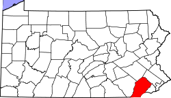
Chester County Pennsylvania incorporated and unincorporated areas Westwood highlighted.svg
Location in Chester County and the state of Pennsylvania.
Coordinates: 39°58′17″N75°51′12″W / 39.97139°N 75.85333°W / 39.97139; -75.85333
Country United States
State Pennsylvania
County Chester
Township Valley
Area
  Total0.5 sq mi (1.2 km2)
  Land0.5 sq mi (1.2 km2)
  Water0.0 sq mi (0.0 km2)
Elevation
360 ft (110 m)
Population
 (2010)
  Total950
  Density2,100/sq mi (790/km2)
Time zone UTC-5 (Eastern (EST))
  Summer (DST) UTC-4 (EDT)
ZIP Code
19320 (Coatesville)
Area code(s) 610
FIPS code 42-84248
GNIS feature ID1191185

Westwood is a census-designated place (CDP) in Valley Township in Chester County, Pennsylvania, United States. The population was 950 at the 2010 census. [1]
Geography

Westwood is located at 39°57′51″N75°53′11″W / 39.96417°N 75.88639°W / 39.96417; -75.88639 , [2] immediately west of the city of Coatesville. Valley Road (Pennsylvania Route 372) passes through the center of the village, connecting Coatesville with Pomeroy and Parkesburg to the west. According to the U.S. Census Bureau, Westwood has a total area of 0.46 square miles (1.2 km2), all land. [3]

Related Research Articles

<span class="mw-page-title-main">Devon, Pennsylvania</span> Census-designated place in Pennsylvania, United States

Devon is a census-designated place (CDP) located in Easttown township in Chester County, Pennsylvania, United States. The population was 1,515 at the 2010 census. The area is part of the Philadelphia Main Line suburbs.

Shavertown is a census-designated place (CDP) in Kingston Township, Luzerne County, Pennsylvania, United States. It lies approximately 7 miles (11 km) northwest of the city of Wilkes-Barre and 24 miles (39 km) southwest of Scranton. The population of the CDP was 2,019 at the 2010 census.

Trucksville is a census-designated place (CDP) in Kingston Township, Luzerne County, Pennsylvania, United States. The population was 2,152 at the 2010 census.

Pardeesville is a census-designated place (CDP) in Hazle Township, Luzerne County, Pennsylvania, United States. The population was 572 at the 2010 census.

Sheatown is a census-designated place (CDP) in Newport Township, Luzerne County, Pennsylvania, United States. It is adjacent to the west side of the city of Nanticoke. The population of Sheatown was 671 at the 2010 census.

West Nanticoke is a census-designated place (CDP) in Plymouth Township, Luzerne County, Pennsylvania, United States, across the Susquehanna River from the city of Nanticoke. The population of the CDP was 749 at the 2010 census.

<span class="mw-page-title-main">Cochranville, Pennsylvania</span> Census-designated place in Pennsylvania, United States

Cochranville is a census-designated place (CDP) in West Fallowfield Township, Chester County, Pennsylvania, United States. The population was 668 at the 2010 census. It is the hometown of Olympic swimmer Cierra Runge.

Harleigh is a census-designated place (CDP) in Hazle Township, Luzerne County, Pennsylvania, United States, north of the city of Hazleton. The CDP population was 1,104 at the 2010 census.

Plains is a census-designated place (CDP) in Plains Township, Luzerne County, Pennsylvania, United States. The population of the CDP was 4,335 at the 2010 census, out of 9,961 in the entire township.

<span class="mw-page-title-main">Inkerman, Pennsylvania</span> Census-designated place in Pennsylvania, United States

Inkerman is a census-designated place (CDP) in Jenkins Township, Luzerne County, Pennsylvania, United States. The population was 1,819 at the 2010 census.

Browntown is a census-designated place (CDP) in Pittston Township, Luzerne County, Pennsylvania, United States, adjacent to Pittston City. The CDP population was 1,418 at the 2010 census.

<span class="mw-page-title-main">Chase, Pennsylvania</span> Census-designated place in Pennsylvania, United States

Chase is a census-designated place (CDP) in Jackson Township, Luzerne County, Pennsylvania, United States. The CDP population was 978 at the 2010 census.

Hickory Hills is a census-designated place (CDP) in Foster Township, Luzerne County, Pennsylvania, southwest of the borough of White Haven. The CDP population was 562 at the 2010 census.

Hilldale is a census-designated place (CDP) in Plains Township, Luzerne County, Pennsylvania, United States. The population was 1,246 at the time of the 2010 census.

Hudson is a census-designated place (CDP) in Plains Township, Luzerne County, Pennsylvania, United States. The population was 1,443 at the 2010 census.

Silkworth is a census-designated place (CDP) in Lehman Township, Luzerne County, Pennsylvania, United States. The population was 820 at the 2010 census.

Upper Exeter is a census-designated place (CDP) in Exeter Township, Luzerne County, Pennsylvania, United States. The population was 707 at the 2010 census.

<span class="mw-page-title-main">Caln, Pennsylvania</span> Census-designated place in Pennsylvania, United States

Caln is a census-designated place (CDP) in Caln Township, Chester County, Pennsylvania, United States. The population was 1,519 at the 2010 census. It is located east of the city of Coatesville and lies west of Philadelphia.

<span class="mw-page-title-main">Eagleview, Pennsylvania</span> Census-designated place in Pennsylvania, United States (Home of Tyler Kroft)

Eagleview is a census-designated place (CDP) in Uwchlan Township, Chester County, Pennsylvania, United States. The population was 1,644 at the 2010 census.

<span class="mw-page-title-main">Pomeroy, Pennsylvania</span> Census-designated place in Pennsylvania, United States

Pomeroy is a census-designated place (CDP) in Sadsbury Township, Chester County, Pennsylvania, United States. The population was 401 at the 2010 census.

References

  1. "Profile of General Population and Housing Characteristics: 2010 Demographic Profile Data (DP-1): Westwood CDP, Pennsylvania". United States Census Bureau . Retrieved August 22, 2012.
  2. US Geological Survey 7.5 minute topographic map series
  3. "Geographic Identifiers: 2010 Demographic Profile Data (G001): Pomeroy CDP, Pennsylvania". United States Census Bureau . Retrieved August 21, 2012.