Kenilworth | |
---|---|
Coordinates: 40°13′46″N75°38′10″W / 40.22944°N 75.63611°W | |
Country | United States |
State | Pennsylvania |
County | Chester |
Township | North Coventry |
Area | |
• Total | 1.75 sq mi (4.52 km2) |
• Land | 1.71 sq mi (4.42 km2) |
• Water | 0.04 sq mi (0.10 km2) |
Elevation | 177 ft (54 m) |
Population | |
• Total | 2,148 |
• Density | 1,258.35/sq mi (485.95/km2) |
Time zone | UTC-5 (EST) |
• Summer (DST) | UTC-4 (EDT) |
ZIP code | |
Area code(s) | 610, 484, & 835 |
FIPS code | 42-39272 |
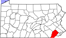
Kenilworth is a census-designated place (CDP) in North Coventry Township, Chester County, Pennsylvania, United States. The population was 2,148 at the 2020 census.
Kenilworth is located at 40°13′46″N75°38′10″W / 40.22944°N 75.63611°W (40.229337, -75.636214). [3]
According to the United States Census Bureau, the CDP has a total area of 1.7 square miles (4.4 km2), of which 0.04 square miles (0.10 km2), or 1.16%, is water.
Kenilworth is located on the south side of the Schuylkill River across from the east side of Pottatown and is served by east-to-west routes PA 724 (East Schuylkill Road) and US 422 (Pottstown Expressway.) Its hardiness zone is 7a and the climate is borderline Cfa/Dfa (humid subtropical/hot summer humid continental.) It is served by the Pottstown post office and telephone exchange.
Census | Pop. | Note | %± |
---|---|---|---|
2000 | 1,576 | — | |
2010 | 1,907 | 21.0% | |
2020 | 2,148 | 12.6% | |
U.S. Decennial Census [4] |
At the 2000 census there were 1,576 people, 680 households, and 461 families living in the CDP. The population density was 924.4 inhabitants per square mile (356.9/km2). There were 711 housing units at an average density of 417.0 per square mile (161.0/km2). The racial makeup of the CDP was 95.18% White, 2.03% African American, 1.52% Asian, 0.13% from other races, and 1.14% from two or more races. Hispanic or Latino of any race were 0.51%. [5]
There were 680 households, 25.4% had children under the age of 18 living with them, 54.7% were married couples living together, 9.3% had a female householder with no husband present, and 32.1% were non-families. 26.6% of households were made up of individuals, and 6.8% were one person aged 65 or older. The average household size was 2.32 and the average family size was 2.79.
The age distribution was 19.3% under the age of 18, 8.8% from 18 to 24, 30.4% from 25 to 44, 24.9% from 45 to 64, and 16.7% 65 or older. The median age was 40 years. For every 100 females, there were 101.0 males. For every 100 females age 18 and over, there were 97.5 males.
The median household income was $43,472 and the median family income was $53,359. Males had a median income of $38,625 versus $28,938 for females. The per capita income for the CDP was $21,849. About 1.1% of families and 3.0% of the population were below the poverty line, including 4.2% of those under age 18 and none of those age 65 or over.
Kenilworth is in the Owen J. Roberts School District. [6] Owen J. Roberts High School is the zoned comprehensive high school.
Matlacha Isles-Matlacha Shores is an unincorporated community and census-designated place (CDP) in Lee County, Florida, United States. The population was 227 at the 2020 census, down from 229 at the 2010 census. It is part of the Cape Coral-Fort Myers, Florida Metropolitan Statistical Area.
West Ferriday is an Unincorporated Community and former census-designated place (CDP) in Concordia Parish, Louisiana, United States. The population was 1,541 at the 2000 census. The area was not delineated as a CDP for the 2010 or the 2020 census.
Amity Gardens is a census-designated place (CDP) in Amity Township, Berks County, Pennsylvania. As of the 2020 census, the CDP had a total population of 3,715. The town lends its name to a Fountains of Wayne song.
Lorane is a census-designated place (CDP) in Exeter Township, Berks County, Pennsylvania. The population was 4,236 at the 2010 census. Located on the Schuylkill River, US Route 422 runs through the town.
North Coventry Township is a township in Chester County, Pennsylvania, United States. The population was 7,866 at the 2010 census.
South Pottstown is a community in North Coventry Township, Chester County in the U.S. state of Pennsylvania. It is defined by the U.S. Census Bureau as a census-designated place (CDP) for statistical purposes and does not have any legal status as a separately incorporated municipality. It is a part of the Pottstown urban area. The population was 2,081 at the 2010 census.
Locustdale is a census-designated place (CDP) that is located on the border of Columbia and Schuylkill counties, Pennsylvania, United States. It is part of Northeastern Pennsylvania.
Halfway House is a census-designated place (CDP) in Montgomery County, Pennsylvania, United States. The population was 3,273 at the 2020 census.
Sanatoga is a community and census-designated place (CDP) that is located in Lower Pottsgrove Township, Montgomery County, Pennsylvania, United States. It is situated immediately east of the borough of Pottstown on U.S. Route 422.
Stowe is a census-designated place (CDP) in West Pottsgrove Township, Montgomery County, Pennsylvania, United States. The population was 3,695 at the 2010 census. It uses the Pottstown ZIP code of 19464.
Altamont is a census-designated place (CDP) in Schuylkill County, Pennsylvania, United States. The population was 2,689 at the 2000 census.
Donaldson is a census-designated place (CDP) in Frailey Township, Schuylkill County, Pennsylvania, United States. The population was 325 at the 2000 census.
Forestville is a census-designated place (CDP) in Schuylkill County, Pennsylvania, United States. The population was 431 at the 2000 census.
Fountain Springs is a census-designated place in Butler Township, Schuylkill County, Pennsylvania, United States. The population was 100 at the 2000 census.
Hometown is a village in Rush Township, Schuylkill County, Pennsylvania, United States that sits astride a crossing point between important transportation corridors. The population was 1,399 at the 2000 census, and excepting for the area near the east–west PA 54 running mostly parallel to the tracks of the Reading, Blue Mountain, and Northern Railroad — once the important east-west shortline Nesquehoning & Mahanoy Railroad — and the PA 54 junction with PA 309.
Lake Wynonah is a census-designated place (CDP) in Schuylkill County, Pennsylvania, United States. The population was 1,961 at the 2000 census, and 2,640 at the 2010 census. Lake Wynonah is a gated community with two lakes, Fawn Lake and Lake Wynonah, and as of July 2008, there are over 1200 homes and 1500 members. It is in South Manheim and Wayne Townships.
McKeansburg is a census-designated place (CDP) in Schuylkill County, Pennsylvania. The population was 169 at the 2020 census.
Newtown is a census-designated place (CDP) in Reilly Township, Schuylkill County in the U.S. state of Pennsylvania. The population was 244 at the 2000 census.
Valley View is a census-designated place (CDP) in Schuylkill County, Pennsylvania, United States. The population was 1,677 at the 2000 census.
Duncott is a census-designated place (CDP) in Schuylkill County, Pennsylvania, United States, near Minersville in the Coal Region. The population was 76 at the 2000 census. It is located in Cass Township.