Jennersville, Pennsylvania | |
|---|---|
Unincorporated community | |
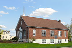 Jennersville Church of the Brethren | |
 Jennersville  Jennersville | |
| Coordinates: 39°49′23″N75°52′11″W / 39.82306°N 75.86972°W | |
| Country | United States |
| State | Pennsylvania |
| County | Chester |
| Township | Penn |
| Elevation | 581 ft (177 m) |
| Time zone | UTC-5 (Eastern (EST)) |
| • Summer (DST) | UTC-4 (EDT) |
| ZIP code | 19390 |
| Area codes | 610 and 484 |
| GNIS feature ID | 1203138 [1] |
Jennersville is an unincorporated community that is located in Penn Township, Chester County, Pennsylvania, United States at latitude 39.823 and longitude -75.87. [2] It is associated, for postal purposes, with the borough of West Grove, and appears on the West Grove U.S. Geological Survey Map.
