Strickersville, Pennsylvania

Last updated
Strickersville, Pennsylvania
USA Pennsylvania location map.svg
Red pog.svg
Strickersville
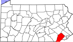
Location within the U.S. state of Pennsylvania
Coordinates: 39°44′2″N75°47′35″W / 39.73389°N 75.79306°W / 39.73389; -75.79306 Coordinates: 39°44′2″N75°47′35″W / 39.73389°N 75.79306°W / 39.73389; -75.79306
Country United States
State Pennsylvania
County Chester
Township London Britain
Elevation
354 ft (108 m)
Time zone UTC-5 (Eastern (EST))
  Summer (DST) UTC-4 (EDT)
ZIP code
19350
Area code(s) 610 and 484
GNIS feature ID1204758 [1]

Strickersville is an unincorporated community in extreme southeastern Chester County, Pennsylvania, United States. It is located at the intersection of Pennsylvania Route 896 and Strickersville Road in London Britain Township. While it once supported a number of small businesses in the late 19th century, today its location is marked only by the aforementioned crossroads and several historic homes. Lunn's Tavern, a large stone and brick building just north of the Strickersville Road intersection, is a listed in the National Register of Historic Places.

Related Research Articles

Garrett County, Maryland County in Maryland, US

Garrett County is the westernmost county of the U.S. state of Maryland. As of the 2010 census, the population was 30,097, making it the third-least populous county in Maryland. Its county seat is Oakland. The county was named for John Work Garrett (1820–1884), president of the Baltimore and Ohio Railroad. Created from Allegany County, Maryland in 1872, it was the last Maryland county to be formed.

Merion Station, Pennsylvania Unincorporated community in Pennsylvania, United States

Merion Station is an unincorporated community in Pennsylvania, United States, bordering Philadelphia to the city's west. It is one of the communities that make up the Philadelphia Main Line, and is part of the municipality of Lower Merion Township, Montgomery County. Merion Station is known for its grand mansions and for the wealth of its residents.

Somerton, Philadelphia Neighborhood of Philadelphia in Philadelphia County, Pennsylvania, United States

Somerton is a neighborhood in the Far Northeast section of Philadelphia, Pennsylvania, United States. The neighborhood is bounded by Red Lion Road on the south, Roosevelt Boulevard on the east, East County Line Road and Poquessing Creek on the north, and the Philadelphia County / Montgomery County line on the west. Somerton is adjacent to the Philadelphia neighborhoods of Bustleton, Normandy, and Byberry, the townships of Bensalem and Lower Southampton in Bucks County, and Lower Moreland Township in Montgomery County. The area is home to a large and fast-growing foreign-born population, most notably of Russian and Indian immigrants.

Concordville, Pennsylvania Unincorporated community in Pennsylvania, United States

Concordville is an unincorporated community in Concord Township, Delaware County, Pennsylvania, United States. It is located 20 miles west-southwest of Philadelphia, at the junction of U.S. Routes 1 and 322. This intersection can be traced back to two of the earliest roads in Pennsylvania, Baltimore Pike which became U.S. 1, and Concord Pike, which connected Pennsylvania with Delaware.

Luxor, Pennsylvania Unincorporated community in Pennsylvania, United States

Luxor is an unincorporated community and coal town in Hempfield Township, Westmoreland County, Pennsylvania, United States.

Sugartown, Pennsylvania United States historic place

Sugartown is an unincorporated settlement in central Willistown Township, Chester County, Pennsylvania, United States, at the intersection of Sugartown and Boot Roads. It is located 18 miles west of Philadelphia.

Penns Park, Pennsylvania Unincorporated community in Pennsylvania, United States

The oldest village in Wrightstown Township, Pennsylvania, Penns Park is located in the center of the township. The zip code is 18943. The crossroads village was known as Logtown as early as 1716 and Pennsville in the early 19th century. In 1862 the village name was changed to its current one. Just outside the village, at the intersection of Penns Park Road and Mud Road, there is still a solitary log house, often called the oldest house in Bucks County. To the southwest of the village is the "old grave yard" where many of the township's first settlers are buried. The Penns Park Historic District and Penn's Park General Store Complex are listed on the National Register of Historic Places.

Beginning Point of the U.S. Public Land Survey United States historic place

The Beginning Point of the U.S. Public Land Survey is the point from which the United States in 1786 began the formal survey of the lands known then as the Northwest Territory, now making up all or part of Ohio, Indiana, Illinois, Michigan, and Wisconsin. The survey is claimed to be the first major cadastral survey undertaken by any nation. The point now lies underwater on the state line between Ohio and Pennsylvania. Because it is submerged, a monument commemorating the point is located on the state line between East Liverpool, Ohio and Ohioville, Pennsylvania, adjacent to the nearest roadway. The area around the marker was designated a National Historic Landmark in 1965.

Eagle, Pennsylvania Unincorporated community in Pennsylvania, United States

Eagle is an unincorporated community in Upper Uwchlan Township, Chester County, Pennsylvania, United States. Located at 40°4′40″N75°41′16″W, the center of the village is the intersection of Pottstown Pike and Little Conestoga Road, where the historic Eagle Tavern is located. Eagle has recently experienced tremendous development in the surrounding areas. A bypass of Route 100 was constructed in the late 1980s to reduce traffic and preserve historic structures such as the Eagle Tavern.

State Route 2005 (Delaware County, Pennsylvania)

State Route 2005 is a major 9.3 mile (15 km) long road, running in a southeast-northwest direction in Delaware County, Pennsylvania. The western terminus is at Pennsylvania Route 320 in Haverford Township, Pennsylvania. Its eastern terminus is at a Cobbs Creek bridge in Darby, Pennsylvania. Past this bridge is State Route 3023, which continues into Philadelphia. SR 2005 is known as Darby Road in Haverford Township, Lansdowne Avenue from U.S. Route 1 to Darby, and Main Street in Darby.

Clayton, Pennsylvania Unincorporated community in Pennsylvania, United States

Clayton is an unincorporated community in Berks County, Pennsylvania, United States. Clayton is located at the intersection of Pennsylvania Route 100, Church Hill Road, and Kutztown Road on the border of Hereford and Washington townships.

Goshenville, Pennsylvania Unincorporated community in Pennsylvania, United States

Goshenville is an unincorporated community in East Goshen Township in Chester County, Pennsylvania, United States. Goshenville is located at the intersection of Pennsylvania Route 352 and Paoli Pike.

At least 13 special routes of U.S. Route 11 and at least one of U.S. Route 11E have existed.

Gardenville, Pennsylvania Unincorporated community in Pennsylvania, United States

Gardenville is an unincorporated community in Plumstead Township in Bucks County, Pennsylvania, United States. Gardenville is located at the intersection of Pennsylvania Route 413 and Point Pleasant Pike.

Dolington, Pennsylvania Unincorporated community in Pennsylvania, United States

Dolington is an unincorporated community in Upper Makefield Township in Bucks County, Pennsylvania, United States. Dolington is located at the intersection of Pennsylvania Route 532 and Dolington Road.

Chesterville, Pennsylvania Unincorporated community in Pennsylvania, United States

Chesterville is an unincorporated community in Franklin Township in Chester County, Pennsylvania, United States. Chesterville is located at the intersection of Pennsylvania Route 841, Chesterville Road, and North Creek Road.

Hood, Pennsylvania Populated place in Pennsylvania, United States

Hood is a populated place situated in New Hope, a borough in Bucks County, Pennsylvania. It has an estimated elevation of 108 feet (33 m) above sea level and is located at the intersection of Mechanic Street and Sugan Road. Nearby the settlement are the Aquetong Creek and New Hope and Ivyland Railroad. The site features ruins of the Robert Heath Mills, a grist mill built in the early 1700s. The original name of this community was Springdale.

Upper Strasburg, Pennsylvania Unincorporated community in Pennsylvania, United States

Upper Strasburg is an unincorporated community in Letterkenny Township in Franklin County, Pennsylvania, United States.

Lederach, Pennsylvania Unincorporated community in Pennsylvania, United States

Lederach is an unincorporated community in Lower Salford Township in Montgomery County, Pennsylvania, United States. Lederach is located at the intersection of Pennsylvania Route 113, Salfordville Road/Morris Road, Old Skippack Road, and Cross Road.

London Grove, Pennsylvania Unincorporated community in Pennsylvania, United States

London Grove is an unincorporated community in West Marlborough Township in Chester County, Pennsylvania, United States. London Grove is located at the intersection of Pennsylvania Route 926 and Newark Road north of Avondale. There was a blacksmithshop and a general store, now the parking lot for an apartment building.

References

  1. "Strickersville". Geographic Names Information System . United States Geological Survey.