West Goshen, Pennsylvania

Last updated

West Goshen, Pennsylvania
USA Pennsylvania location map.svg
Red pog.svg
West Goshen, Pennsylvania
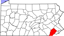
Location of West Goshen in Pennsylvania
Usa edcp location map.svg
Red pog.svg
West Goshen, Pennsylvania
West Goshen, Pennsylvania (the United States)
Coordinates: 39°58′03″N75°34′29″W / 39.96750°N 75.57472°W / 39.96750; -75.57472
CountryUnited States
StatePennsylvania
County Chester
Township West Goshen
Area
  Total3.2 sq mi (8 km2)
  Land3.2 sq mi (8 km2)
  Water0.0 sq mi (0 km2)
Elevation
436 ft (133 m)
Population
 (2000)
  Total8,472
  Density2,600/sq mi (1,000/km2)
Time zone UTC-5 (EST)
  Summer (DST) UTC-4 (EDT)
Area code 610

West Goshen was a census-designated place (CDP) in West Goshen Township, Chester County, Pennsylvania, United States. The population was 8,472 at the 2000 census. The CDP was not delineated for the 2010 census.

Contents

Geography

West Goshen Township is located at 39°58′3″N75°34′29″W / 39.96750°N 75.57472°W / 39.96750; -75.57472 (39.967408, -75.574679). [1]

According to the United States Census Bureau, the CDP had a total area of 3.2 square miles (8.3 km2), all land.

Demographics

At the 2000 census there were 8,472 people, 3,310 households, and 2,191 families living in the CDP. The population density was 2,663.7 inhabitants per square mile (1,028.5/km2). There were 3,376 housing units at an average density of 1,061.5 per square mile (409.8/km2). The racial makeup of the CDP was 87.75% White, 4.96% African American, 0.09% Native American, 5.61% Asian, 0.01% Pacific Islander, 0.76% from other races, and 0.83% from two or more races. Hispanic or Latino of any race were 2.28%. [2]

There were 3,310 households, 30.5% had children under the age of 18 living with them, 55.9% were married couples living together, 7.3% had a female householder with no husband present, and 33.8% were non-families. 25.8% of households were made up of individuals, and 6.8% were one person aged 65 or older. The average household size was 2.50 and the average family size was 3.09.

The age distribution was 22.6% under the age of 18, 7.9% from 18 to 24, 32.6% from 25 to 44, 24.4% from 45 to 64, and 12.4% 65 or older. The median age was 37 years. For every 100 females, there were 100.7 males. For every 100 females age 18 and over, there were 97.4 males.

The median household income was $59,505 and the median family income was $71,573. Males had a median income of $44,773 versus $33,979 for females. The per capita income for the CDP was $27,912. About 1.5% of families and 4.1% of the population were below the poverty line, including 3.9% of those under age 18 and 3.1% of those age 65 or over.

Related Research Articles

<span class="mw-page-title-main">Tobin, California</span> Census-designated place in California, United States

Tobin is a census-designated place (CDP) in Plumas County, California, United States. The population was 12 at the 2010 census, up from 11 at the 2000 census.

<span class="mw-page-title-main">Terra Bella, California</span> Census-designated place in California, United States

Terra Bella is a census-designated place (CDP) in Tulare County, California, United States. The population was 2,910 at the 2020 census, down from 3,310 at the 2010 census.

<span class="mw-page-title-main">Highland Acres, Delaware</span> CDP in Delaware, United States

Highland Acres is a census-designated place (CDP) in Kent County, Delaware, United States. It is part of the Dover, Delaware Metropolitan Statistical Area. The population was 3,459 at the 2010 census.

<span class="mw-page-title-main">Woodside East, Delaware</span> CDP in Delaware, United States

Woodside East is a census-designated place (CDP) in Kent County, Delaware, United States. It is part of the Dover, Delaware Metropolitan Statistical Area. The population was 2,316 at the 2010 census.

<span class="mw-page-title-main">Edgemoor, Delaware</span> CDP in Delaware, United States

Edgemoor is a census-designated place in New Castle County, Delaware, United States. The population was 5,677 at the 2010 census.

<span class="mw-page-title-main">Kealakekua, Hawaii</span> Census-designated place in Hawaii, U.S.

Kealakekua is a census-designated place (CDP) in Hawaiʻi County, Hawaiʻi, United States. The population was 2,019 at the 2010 census, up from 1,645 at the 2000 census.

<span class="mw-page-title-main">Puako, Hawaii</span> Census-designated place in Hawaii, U.S.

Puako is a census-designated place (CDP) in Hawaiʻi County, Hawaii, United States. The population was 772 at the 2010 census, up from 429 at the 2000 census. The epicenter of the 2006 Kiholo Bay earthquake was some 6 miles (10 km) offshore of the village.

<span class="mw-page-title-main">Rossville, Maryland</span> Census-designated place in Maryland, United States

Rossville is an unincorporated community and census-designated place in Baltimore County, Maryland, United States. The population was 15,147 at the 2010 census.

<span class="mw-page-title-main">Hayward, Missouri</span> Census-designated place in Missouri, United States

Hayward is a census-designated place and former village in Pemiscot County, Missouri, United States. The population was 131 at the 2010 census.

Clark Mills is a hamlet in Oneida County, New York, United States. The population was 1,905 at the 2010 census.

<span class="mw-page-title-main">Mount Repose, Ohio</span> Census-designated place in Ohio, United States

Mount Repose is a census-designated place (CDP) in Miami Township, Clermont County, Ohio, United States. The population was 4,648 at the 2020 census.

<span class="mw-page-title-main">Logan Elm Village, Ohio</span> CDP in Ohio, United States

Logan Elm Village is a census-designated place (CDP) in Pickaway County, Ohio, United States, near the site of the Logan Elm. The population was 1,062 at the 2000 census.

West Wyomissing is a census-designated place (CDP) in Spring Township, Berks County, Pennsylvania, United States. The population was 3,407 at the 2010 census.

<span class="mw-page-title-main">Burlington Township, Bradford County, Pennsylvania</span> Township in Pennsylvania, United States

Burlington Township is a township in Bradford County, Pennsylvania, United States. It is part of Northeastern Pennsylvania. The population was 791 at the 2010 census. Children residing in the township are assigned to attend the Troy Area School District.

<span class="mw-page-title-main">Atlantic, Pennsylvania</span> Census-designated place in Pennsylvania, United States

Atlantic is a census-designated place (CDP) in Crawford County, Pennsylvania, United States. The population was 77 at the 2010 census, up from 43 in 2000.

<span class="mw-page-title-main">Grantley, Pennsylvania</span> CDP in Pennsylvania, United States

Grantley is a census-designated place (CDP) in York County, Pennsylvania, United States. The population was 3,628 at the 2010 census.

<span class="mw-page-title-main">Weigelstown, Pennsylvania</span> CDP in Pennsylvania, United States

Weigelstown is a census-designated place (CDP) in York County, Pennsylvania, United States. The population was 12,875 at the 2010 census.

<span class="mw-page-title-main">Green Valley, South Dakota</span> CDP in South Dakota, United States

Green Valley is a census-designated place (CDP) and unincorporated community in Pennington County, South Dakota, United States. The population was 1,051 at the 2020 census.

Fairmount is a census-designated place (CDP) in Hamilton County, Tennessee, United States. The population was 2,193 at the 2020 census, down from 2,825 at the 2010 census. It is part of the Chattanooga, TN–GA Metropolitan Statistical Area.

<span class="mw-page-title-main">Elwood, New Jersey</span> Populated place in Atlantic County, New Jersey, US

Elwood is an unincorporated community and census-designated place (CDP) located within Mullica Township in Atlantic County, in the U.S. state of New Jersey. As of the 2010 United States Census, the CDP's population was 1,437. At previous censuses, the area was listed by the U.S. Census Bureau as the Elwood-Magnolia CDP. The area is served as United States Postal Service ZIP Code 08217.

References

  1. "US Gazetteer files: 2010, 2000, and 1990". United States Census Bureau. February 12, 2011. Retrieved April 23, 2011.
  2. "U.S. Census website". United States Census Bureau . Retrieved January 31, 2008.