Kemblesville, Pennsylvania

Last updated

Kemblesville, Pennsylvania
Kemblesville PA house.JPG
House in Kemblesville
USA Pennsylvania location map.svg
Red pog.svg
Kemblesville
Location within the U.S. state of Pennsylvania
Coordinates: 39°44′56″N75°49′28″W / 39.74889°N 75.82444°W / 39.74889; -75.82444
Country United States
State Pennsylvania
County Chester
Township Franklin
Time zone UTC-5 (Eastern (EST))
  Summer (DST) UTC-4 (EDT)
ZIP code
19347
Area code(s) 610 and 484

Kemblesville is an unincorporated community in Franklin Township, Chester County, Pennsylvania, United States. Located in the southern part of the county, it lies in the southeastern part of the state.

Contents

History

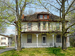
The roots of the village of Kemblesville date back to the late 18th century. Its historic houses and outbuildings are now part of the Kemblesville Historic District, which largely preserves Kemblesville as it appeared in the late 19th century. Originally called Fox Chase, the community derives its present name from the Kemble, or Kimble, family, who settled the area in colonial times and were prominent in the village in the 1800s. Members of the Kemble family are buried in the graveyard at the Kemblesville Methodist church. Kimbelot Lane also derives its name from the family; Parsons Road, to the village's north, derives its name from the Parsons family. Benjamin Franklin is thought to have owned property within the village limits, and the surrounding township is named after him.

In addition to village's historic homes and church, there are a school, a gas station, two automobile repair shops, a pizza parlor, a doctor's office, and a day care center. A building intended for a Happy Harry's drug store was completed but never opened, and the unused property is now a day care center. The US Postal Service maintains a modern post office at the southern edge of the village next to the township municipal building and facilities.

Kemblesville Elementary

The school was built in 1955 and was part of the Avon Grove School District. As part of a reorganization in 2002, the school was closed and replaced by the Penn London Elementary School, housing grades K-2, and the Avon Grove Intermediate School, housing grades 3-6, on a single campus on the Penn Township - New London Township border. The elementary school site was acquired by the Avon Grove Charter School, which reopened the building on September 2, 2008. The facility houses grades K-3.

Location

Another house in Kemblesville Kemblesville PA white house.JPG
Another house in Kemblesville

Kemblesville is located 15 minutes northwest of Newark, Delaware. While the area remains relatively rural, increasing development pressures are slowly bringing change to the village and its township.

The local ZIP code is 19347.

Related Research Articles

<span class="mw-page-title-main">Lockport, Illinois</span> City in Illinois, United States

Lockport is a city in Will County, Illinois, United States, located 30 miles southwest of Chicago. Per the 2020 census, the population was 26,094. The city was incorporated in 1853. It is situated along the Illinois and Michigan (I&M) Canal, and was the headquarters of the canal when the canal was operating. A section of the canal runs through Lockport, including the remains of the canal's Lock No. 1 from which the town received its name. The canal right-of-way is now the Illinois and Michigan National Heritage Corridor.

<span class="mw-page-title-main">Beech Grove, Indiana</span> City in Indiana, United States

Beech Grove is a city in Marion County, Indiana, United States. As of the 2020 census, the city's population is 14,717. The city is located within the Indianapolis metropolitan area. Beech Grove is designated an "excluded city" under Indiana law, as it is not part of the consolidated government of Indianapolis and Marion County.

<span class="mw-page-title-main">Easttown Township, Chester County, Pennsylvania</span> Township in Pennsylvania, United States

Easttown Township is a township in Chester County, Pennsylvania, United States. The population was 10,984 at the 2020 census. The township, which lies in the western half of Philadelphia's Main Line suburbs, comprises mostly parts of two unincorporated areas: Devon and Berwyn. A small portion of the township has a Paoli address.

<span class="mw-page-title-main">West Grove, Pennsylvania</span> Borough in Pennsylvania, United States

West Grove is a borough in Chester County, Pennsylvania, United States. The population was 2,775 at the 2020 census.

<span class="mw-page-title-main">Emmaus, Pennsylvania</span> Borough in Pennsylvania, United States

Emmaus is a borough in Lehigh County, Pennsylvania. As of the 2020 U.S. census, it had a population of 11,652. Emmaus is located in the Lehigh Valley, the third-largest metropolitan area in Pennsylvania and 68th-largest metropolitan area in the nation.

<span class="mw-page-title-main">Lower Milford Township, Lehigh County, Pennsylvania</span> Township in Pennsylvania, United States

Lower Milford Township is a township in Lehigh County, Pennsylvania. The population of Lower Milford Township was 3,775 at the 2010 census. It is a suburb of Allentown in the Lehigh Valley region of eastern Pennsylvania.

<span class="mw-page-title-main">South Whitehall Township, Lehigh County, Pennsylvania</span> Township in Pennsylvania, United States

South Whitehall Township is a township in Lehigh County, Pennsylvania. The township's population was 19,180 at the 2010 census. It is a suburb of Allentown and is part of the Lehigh Valley, which had a population of 861,899 and was the 68th-most populous metropolitan area in the U.S. as of the 2020 census.

<span class="mw-page-title-main">Abington Township, Montgomery County, Pennsylvania</span> Township in Pennsylvania, United States

Abington Township is a township in Montgomery County, Pennsylvania, United States. It is adjacent to Philadelphia's northern fringe. The population was 58,502 as of the 2020 census, making it the second most populous township in Montgomery County after Lower Merion Township. The population density is 3603.3 per square mile (1,377/km2), making it the second most densely populated township in Montgomery County after Cheltenham Township.

<span class="mw-page-title-main">Upper Merion Township, Pennsylvania</span> Township in Pennsylvania, United States of America

Upper Merion Township is a township in Montgomery County, Pennsylvania. The population was 33,613 at the 2020 U.S. Census. Located 16 miles (26 km) from Philadelphia, it consists of the villages of Gulph Mills, King of Prussia, Swedeland, Swedesburg, and portions of Radnor, and Wayne.

<span class="mw-page-title-main">Delmont, Pennsylvania</span> Borough in Pennsylvania, United States

Delmont is a borough in Westmoreland County, Pennsylvania. The population was 2,592 at the 2020 census.

<span class="mw-page-title-main">Nether Providence Township, Delaware County, Pennsylvania</span> Township in Pennsylvania, United States

Nether Providence Township is a first class township in Delaware County, Pennsylvania, United States. Many residents refer to the township by the name of its largest community, Wallingford, because the Wallingford postal code is used for most of the township. The population of the township was 13,706 at the 2010 census.

<span class="mw-page-title-main">Bredon</span> Human settlement in England

Bredon is a village and civil parish in Wychavon district at the southern edge of Worcestershire in England. It lies on the banks of the River Avon on the lower slopes of Bredon Hill.

<span class="mw-page-title-main">Penngrove, California</span> Census-designated place in California, United States

Penngrove is a census-designated place (CDP) in Sonoma County, California, United States, situated between the cities of Petaluma and Cotati, at the foot of the western flank of Sonoma Mountain. It is part of the North Bay subregion of the San Francisco Bay Area. The population was 2,522 at the 2010 census.

<span class="mw-page-title-main">Darlington, Maryland</span> Historic district in Maryland, United States

Darlington is an unincorporated community and census-designated place in northeastern Harford County, Maryland, United States. The population was 409 at the 2010 census. The center of the community was listed on the National Register of Historic Places as the Darlington Historic District in 1987. Median household income is $66,563. The percentage of people in poverty is 5.3%.

<span class="mw-page-title-main">Alderwood, Toronto</span> Neighbourhood in Toronto, Ontario, Canada

Alderwood is a neighbourhood in the city of Toronto, Ontario, Canada. It is in the western section of Toronto, within the district of Etobicoke. It is bounded by the Etobicoke Creek to the west, the Gardiner Expressway to the north, the CPR railway to the east and the CNR railway to the south.

The Avon Grove School District (AGSD) is a publicly funded, K-12 school district located in Chester County, Pennsylvania, serving over 5,000 students in four schools: Penn London Elementary School (K–2), Avon Grove Intermediate School (3–6), Fred S. Engle Middle School (7–8) and Avon Grove High School (9–12).

<span class="mw-page-title-main">Spring Garden, Philadelphia</span> Historic neighborhood in Pennsylvania, United States

Spring Garden is a neighborhood in central Philadelphia, Pennsylvania, United States, bordering Center City on the north. Spring Garden is a neighborhood that combines diverse residential neighborhoods and significant cultural attractions. The residential areas on the north side of the neighborhood are composed mostly of brick and brownstone three-story townhouses built during the mid-to-late 19th century. The houses include townhouses in the Italianate style, Second Empire, Queen Anne, and Venetian Gothic. Many streets include "terraced" set ups, which include a small gardened plot, often raised, in front of the house. The residential areas to the south are dominated by taller, multi-family buildings built during the 20th century. The museum area, also to the south of Spring Garden Street, includes the Rodin Museum, the Central Library of Philadelphia, and the Barnes Museum. Before consolidation of Philadelphia, Spring Garden was a district of Philadelphia County.

<span class="mw-page-title-main">Lawndale, Philadelphia</span> Neighborhood of Philadelphia in Philadelphia County, Pennsylvania, United States

Lawndale is a neighborhood in Northeast Philadelphia, Pennsylvania, United States. It is located near Rising Sun and Oxford avenues and is south of Cottman Avenue.

Zionsville is a village mostly in Upper Milford Township in Lehigh County, Pennsylvania with parts of the village located in Lower Milford Township. The West Branch Hosensack Creek forms its natural southeastern boundary and drains it via the Hosensack Creek to the Perkiomen Creek.

<span class="mw-page-title-main">Briggsdale (Columbus, Ohio)</span>

Briggsdale is a neighborhood of Franklin County in the city of Columbus, Ohio. The neighborhood is on the west/southwest side of the city within the Hilltop area. The area was first settled and founded by the family of Joseph M. Briggs, after whom the neighborhood was named. Joseph Briggs was an active figure in the early years of the township and county operations. The Briggsdale Methodist church was founded with his help, and it now exists as the New Horizons Methodist Church. The present day Briggsdale neighborhood is located near the historical Green Lawn Cemetery to the north as well as Briggs High School to the west.

References