Pomeroy, Pennsylvania

Last updated

Pomeroy, Pennsylvania
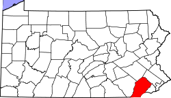
Chester County Pennsylvania incorporated and unincorporated areas Pomeroy highlighted.svg
Location in Chester County and the state of Pennsylvania.
Coordinates: 39°57′51″N75°53′11″W / 39.96417°N 75.88639°W / 39.96417; -75.88639
Country United States
State Pennsylvania
County Chester
Township Sadsbury
Area
[1]
  Total
0.47 sq mi (1.21 km2)
  Land0.47 sq mi (1.20 km2)
  Water0.00 sq mi (0.01 km2)
Elevation
484 ft (148 m)
Population
 (2020) [2]
  Total
1,085
  Density2,333.33/sq mi (901.77/km2)
Time zone UTC-5 (Eastern (EST))
  Summer (DST) UTC-4 (EDT)
ZIP code
19367
Area code(s) 610 and 484
FIPS code 42-61968

Pomeroy is a census-designated place (CDP) in Sadsbury Township, Chester County, Pennsylvania, United States. The population was 401 at the 2010 census. [3]

Contents

It was once the northern terminus of the Pomeroy and Newark Railroad until passenger service was terminated in 1928. [4]
Geography

Pomeroy is located at 39°57′51″N75°53′11″W / 39.96417°N 75.88639°W / 39.96417; -75.88639 [5] in the southeast corner of Sadsbury Township. Pennsylvania Route 372 passes through the center of the village, connecting Coatesville 3 miles (5 km) to the east with Parkesburg 1 mile (1.6 km) to the west.

According to the United States Census Bureau, the CDP has a total area of 0.33 square miles (0.86 km2), of which 0.33 square miles (0.85 km2) is land and 0.004 square miles (0.01 km2), or 0.88%, is water. [6]

Demographics

Historical population
CensusPop.Note
2010 401
2020 1,085170.6%
U.S. Decennial Census [7]

Education

The school district is Coatesville Area School District. [8]

Related Research Articles

<span class="mw-page-title-main">Eden Township, Pennsylvania</span> Township in Pennsylvania, United States

Eden Township is a township in southeastern Lancaster County, Pennsylvania, United States. At the 2020 census, the population was 2,248. It is part of the Solanco School District.

<span class="mw-page-title-main">Atglen, Pennsylvania</span> Borough in Pennsylvania, United States

Atglen is a borough in Chester County, Pennsylvania, United States. According to the 2020 census, its population is 1,311.

<span class="mw-page-title-main">Exton, Pennsylvania</span> Census-designated place in Pennsylvania, United States

Exton is a census-designated place (CDP) in West Whiteland Township in Chester County, Pennsylvania, United States. Its population was 5,622 at the 2020 census. The Exton Square Mall and Main Street at Exton are both located within Exton along with several other shopping centers, making Exton the major shopping district in Chester County.

<span class="mw-page-title-main">Sadsbury Township, Chester County, Pennsylvania</span> Township in Pennsylvania, United States

Sadsbury Township is a township in Chester County, Pennsylvania, United States. The population was 4,125 at the 2020 census.

<span class="mw-page-title-main">South Coatesville, Pennsylvania</span> Borough in Pennsylvania, United States

South Coatesville is a borough that is located in Chester County, Pennsylvania, United States. The population was 1,604 at the time of the 2020 census.

<span class="mw-page-title-main">Thorndale, Pennsylvania</span> Census-designated place in Pennsylvania, United States

Thorndale is a census-designated place in Caln Township, Chester County, Pennsylvania, United States. The population was 3,407 at the 2010 census.

<span class="mw-page-title-main">Toughkenamon, Pennsylvania</span> Census-designated place in Pennsylvania, United States

Toughkenamon is a census-designated place (CDP) in New Garden Township, Chester County, Pennsylvania, United States. The population was 1,492 at the 2010 census.

<span class="mw-page-title-main">West Brandywine Township, Pennsylvania</span> Township in Pennsylvania, United States

West Brandywine Township is a township that is located in Chester County, Pennsylvania, United States. The population was 7,394 at the time of the 2010 census.

<span class="mw-page-title-main">West Sadsbury Township, Pennsylvania</span> Township in Pennsylvania, United States

West Sadsbury Township is a township in Chester County, Pennsylvania, United States. The population was 2,444 at the 2010 census.

<span class="mw-page-title-main">Broomall, Pennsylvania</span> Census-designated place in Pennsylvania, United States

Broomall is a census-designated place (CDP) in Marple Township, Delaware County, Pennsylvania, United States. The population was 10,789 at the 2010 census.

<span class="mw-page-title-main">Lima, Pennsylvania</span> Census-designated place in Pennsylvania, United States

Lima is an unincorporated community and census-designated place (CDP) in Middletown Township, Delaware County, Pennsylvania, United States. The population was 2,735 at the 2010 census, down from 3,225 at the 2000 census.

<span class="mw-page-title-main">Village Green-Green Ridge, Pennsylvania</span> Census-designated place in Pennsylvania, United States

Village Green-Green Ridge is a census-designated place (CDP) in Aston Township, Delaware County, Pennsylvania, United States. The population was 7,822 at the 2010 census, down from 8,279 at the 2000 census.

<span class="mw-page-title-main">Devon, Pennsylvania</span> Census-designated place in Pennsylvania, United States

Devon is a census-designated place (CDP) located in Easttown township in Chester County, Pennsylvania, United States. The population was 1,515 at the 2010 census. The area is part of the Philadelphia Main Line suburbs.

<span class="mw-page-title-main">Cochranville, Pennsylvania</span> Census-designated place in Pennsylvania, United States

Cochranville is a census-designated place (CDP) in West Fallowfield Township, Chester County, Pennsylvania, United States. The population was 668 at the 2010 census. It is the hometown of Olympic swimmer Cierra Runge.

Hickory Hills is a census-designated place (CDP) in Foster Township, Luzerne County, Pennsylvania, southwest of the borough of White Haven. The CDP population was 562 at the 2010 census.

Hudson is a census-designated place (CDP) in Plains Township, Luzerne County, Pennsylvania, United States. The population was 1,443 at the 2010 census.

Upper Exeter is a census-designated place (CDP) in Exeter Township, Luzerne County, Pennsylvania, United States. The population was 707 at the 2010 census.

<span class="mw-page-title-main">Caln, Pennsylvania</span> Census-designated place in Pennsylvania, United States

Caln is a census-designated place (CDP) in Caln Township, Chester County, Pennsylvania, United States. The population was 1,519 at the 2010 census. It is located east of the city of Coatesville and lies west of Philadelphia.

<span class="mw-page-title-main">Westwood, Chester County, Pennsylvania</span> Census-designated place in Pennsylvania, United States

Westwood is a census-designated place (CDP) in Valley Township in Chester County, Pennsylvania, United States. The population was 950 at the 2010 census.

<span class="mw-page-title-main">Soudersburg, Pennsylvania</span> Census-designated place in Pennsylvania, United States

Soudersburg is an unincorporated community and census-designated place (CDP) in East Lampeter and Leacock townships in Lancaster County, Pennsylvania, United States. As of the 2010 census, the population was 540.

References

  1. "ArcGIS REST Services Directory". United States Census Bureau. Retrieved October 16, 2022.
  2. "Census Population API". United States Census Bureau. Retrieved October 16, 2022.
  3. "Profile of General Population and Housing Characteristics: 2010 Demographic Profile Data (DP-1): Sadsbury CDP, Pennsylvania". United States Census Bureau . Retrieved August 21, 2012.
  4. "Tracing the history of the Pomeroy and Newark Railroad | Chester County Press". www.chestercounty.com. Retrieved May 30, 2023.
  5. US Geological Survey 7.5 minute topographic map series
  6. "Geographic Identifiers: 2010 Demographic Profile Data (G001): Pomeroy CDP, Pennsylvania". United States Census Bureau . Retrieved August 21, 2012.
  7. "Census of Population and Housing". Census.gov. Retrieved June 4, 2016.
  8. "2020 CENSUS - SCHOOL DISTRICT REFERENCE MAP: Chester County, PA" (PDF). U.S. Census Bureau. Archived (PDF) from the original on October 9, 2022. Retrieved December 13, 2024. - Text list