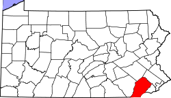
Lenape, Pennsylvania

Last updated

Lenape, Pennsylvania
Unincorporated community
USA Pennsylvania location map.svg
Red pog.svg
Lenape
Usa edcp location map.svg
Red pog.svg
Lenape
Coordinates: 39°54′46″N75°37′54″W / 39.91278°N 75.63167°W / 39.91278; -75.63167
Country United States
State Pennsylvania
County Chester
Township Pocopson
Elevation
194 ft (59 m)
Time zone UTC-5 (Eastern (EST))
  Summer (DST) UTC-4 (EDT)
Area code(s) 610 and 484
GNIS feature ID1204010 [1]

Lenape is an unincorporated community in Pocopson Township in Chester County, Pennsylvania, United States. Lenape is centered on the intersection of Pennsylvania Route 52 and Pocopson Road, west of the Brandywine Creek. [2]

History

A post office called Lenape was established in 1870, and remained in operation until it was discontinued in 1923. [3] The community was named after the Lenape Indians. [4]

Related Research Articles

<span class="mw-page-title-main">Chester County, Pennsylvania</span> County in Pennsylvania, United States

Chester County is a county in the Commonwealth of Pennsylvania. It is located in the Delaware Valley region, located in the southeastern part of the state. As of the 2020 census, the population was 534,413, increasing by 7.1% from 498,886 in 2010. The county seat and most populated municipality is West Chester. Chester County was one of the three original Pennsylvania counties created by William Penn in 1682. It was named for Chester, England.

<span class="mw-page-title-main">Birmingham Township, Chester County, Pennsylvania</span> Township in Pennsylvania, United States

Birmingham Township is a township in Chester County, Pennsylvania, United States. The population was 4,085 at the 2020 census.

<span class="mw-page-title-main">East Bradford Township, Pennsylvania</span> Township in Pennsylvania, United States

East Bradford Township is a township in Chester County, Pennsylvania, United States. The population was 10,308 at the 2020 census.

<span class="mw-page-title-main">East Marlborough Township, Pennsylvania</span> Township in Pennsylvania, United States

East Marlborough Township is a township in Chester County, Pennsylvania, United States. The population was 7,026 at the 2010 census. East Marlborough and West Marlborough townships were carved out of the larger Marlborough Township in 1729. The township is home to many Penn Oak trees, trees that were in existence when William Penn explored the area.

<span class="mw-page-title-main">Pocopson Township, Pennsylvania</span> Township in Pennsylvania, United States

Pocopson Township is a township in Chester County, Pennsylvania, United States. The population was 4,582 at the 2010 census.

<span class="mw-page-title-main">Concord Township, Delaware County, Pennsylvania</span> Township in Pennsylvania, United States

Concord Township is a township in Delaware County, Pennsylvania, United States. The population was 17,231 at the 2010 census. It contains the unincorporated communities of Concordville and Glen Mills.

<span class="mw-page-title-main">Marcus Hook, Pennsylvania</span> Borough in Pennsylvania, United States

Marcus Hook is a borough in Delaware County, Pennsylvania, United States. The population was 2,397 at the 2010 census. The current mayor is Gene Taylor. The borough calls itself "The Cornerstone of Pennsylvania". The 2005 film One Last Thing... was set and partially filmed in Marcus Hook.

<span class="mw-page-title-main">Ridley Park, Pennsylvania</span> Borough in Pennsylvania, United States

Ridley Park is a borough in Delaware County, Pennsylvania, United States. The population was 7,002 at the 2010 census. Ridley Park is the home of Boeing's CH-47 Chinook helicopter division.

<span class="mw-page-title-main">Brandywine Creek (Christina River tributary)</span> Creek in Pennsylvania and Delaware, US

Brandywine Creek is a tributary of the Christina River in southeastern Pennsylvania and northern Delaware in the United States. The Lower Brandywine is 20.4 miles (32.8 km) long and is a designated Pennsylvania Scenic River with several tributary streams. The East Branch and West Branch of the creek originate within 2 miles (3 km) of each other on the slopes of Welsh Mountain in Honey Brook Township, Pennsylvania, about 20 miles (32 km) northwest of their confluence.

<span class="mw-page-title-main">Pennsylvania Route 52</span> State highway in Chester County, Pennsylvania, US

Pennsylvania Route 52 is a 11.8-mile-long (19.0 km) state highway located in southeast Pennsylvania. The southern terminus of the route is at the Pennsylvania-Delaware state line near Kennett Square, where the road continues as Delaware Route 52. The northern terminus is at U.S. Route 322 Business in West Chester. Near the Kennett Township community of Longwood, it has about a 1-mile (1.6 km) wrong-way concurrency with US 1. PA 52 passes through suburban and rural areas along its route.

Landenberg is an unincorporated community that is located in southern Chester County, Pennsylvania, United States. It is, essentially, a post office address that covers parts of New Garden, London Britain and Franklin Townships.

<span class="mw-page-title-main">Pennsylvania Route 926</span> State highway in Pennsylvania, US

Pennsylvania Route 926 is a 26.2-mile-long (42.2 km) state route located west of Philadelphia in Chester County, Pennsylvania. The western terminus of the route is at PA 10 in Upper Oxford Township. The eastern terminus is at PA 3 in the Philadelphia suburb of Willistown Township. The route is known as Street Road for its entire length. For 0.9 miles (1.4 km), PA 926 runs along the county line between Delaware and Chester counties. The route passes through a mix of suburban and rural areas along its extent. PA 926 is two lanes and undivided its entire length.

<span class="mw-page-title-main">Cocalico Creek</span> River in Pennsylvania, United States

Cocalico Creek is a 27.2-mile-long (43.8 km) tributary of the Conestoga River in Lebanon and Lancaster counties in Pennsylvania in the United States. The source is at an elevation of 1,320 feet (400 m) near Stricklerstown in Millcreek Township, Lebanon County. The mouth is the confluence with the Conestoga River at an elevation of 278 feet (85 m) at Talmage in West Earl Township, Lancaster County.

<span class="mw-page-title-main">Smedley Darlington</span> American politician

Smedley Darlington was an American politician who served as a Republican member of the U.S. House of Representatives for Pennsylvania's 6th congressional district from 1887 to 1891.

The West Branch Brandywine Creek is a 33.1-mile-long (53.3 km) tributary of Brandywine Creek in Chester County, Pennsylvania in the United States.

Wagontown is an unincorporated community in West Caln Township, Chester County, Pennsylvania, United States. Wagontown is located along Pennsylvania Route 340, 2.15 miles (3.46 km) north-northwest of Coatesville. Wagontown has a post office with ZIP code 19376. The Hibernia House, which is listed on the National Register of Historic Places, is located near Wagontown.

<span class="mw-page-title-main">Lenape Bridge</span> United States historic place

Lenape Bridge is a historic stone arch bridge located in Birmingham Township and Pocopson Township, Chester County, Pennsylvania. It has a seven spans, each 44-foot-long (13 m), with a total length of 308-foot (94 m). The bridge was constructed in 1911–1912, of random rubble stone.

Pocopson is an unincorporated community in Pocopson Township in Chester County, Pennsylvania, United States. Pocopson is located at the intersection of Pennsylvania Route 926 and Pocopson Road.

<span class="mw-page-title-main">Llanerch, Pennsylvania</span> Unincorporated community in Delaware County, Pennsylvania

Llanerch is an unincorporated community on the border of Haverford Township and Upper Darby Township in Delaware County, Pennsylvania, United States. Llanerch is located at the intersection of U.S. Route 1, Pennsylvania Route 3, and Darby Road.

<span class="mw-page-title-main">Eusebius Barnard</span> American farmer, minister and abolitionist (1802–1865)

Eusebius Barnard was an American farmer and station master on the Underground Railroad in Chester County, Pennsylvania, helping hundreds of fugitive slaves escape to freedom. A minister of the Progressive Friends and founding member of Longwood Meeting House, Barnard championed women’s rights, temperance, and abolition of slavery. A Pennsylvania state historical marker was placed outside his home in Pocopson Township on April 30, 2011.

References

  1. "Lenape". Geographic Names Information System . United States Geological Survey, United States Department of the Interior.
  2. Chester County, Pennsylvania Highway Map (PDF) (Map). PennDOT. 2012. Retrieved August 22, 2013.[ permanent dead link ]
  3. "Chester County". Jim Forte Postal History. Retrieved June 14, 2015.
  4. Gannett, Henry (1905). The Origin of Certain Place Names in the United States. U.S. Government Printing Office. p.  185.