Sadsburyville, Pennsylvania

Last updated

Sadsburyville, Pennsylvania
Unincorporated community
Sadsburyville Chesco PA 3.JPG
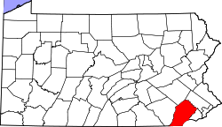
USA Pennsylvania location map.svg
Red pog.svg
Sadsburyville
Coordinates: 39°58′54″N75°53′29″W / 39.98167°N 75.89139°W / 39.98167; -75.89139
Country United States
State Pennsylvania
County Chester
Township Sadsbury
Elevation
640 ft (200 m)
Time zone UTC-5 (Eastern (EST))
  Summer (DST) UTC-4 (EDT)
ZIP code
19369
Area code(s) 610 and 484
GNIS feature ID1185712 [1]

Sadsburyville is an unincorporated area in Sadsbury Township in Chester County, Pennsylvania, United States

Contents

History and Geography

Sadsburyville is located at the intersection of U.S. Route 30 Business and Old Wilmington Road, approximately four miles west of Coatesville and about three miles northeast of Parkesburg. [2]

Education

The school district is Coatesville Area School District. [3]

Related Research Articles

<span class="mw-page-title-main">Chester County, Pennsylvania</span> County in Pennsylvania, United States

Chester County, colloquially referred to as Chesco, is a county in the Commonwealth of Pennsylvania. It is located in the Delaware Valley region, located in the southeastern part of the state. As of the 2020 census, the population was 545,823. increasing by 7.1% from 498,886 in 2010. The county seat is West Chester. The most populous of the county's 73 municipalities, including cities, boroughs, and townships,) is Tredyffrin Township. The most populous boroughs are West Chester and Phoenixville. Coatesville is the only municipality in the county that is classified as a city.

<span class="mw-page-title-main">Atglen, Pennsylvania</span> Borough in Pennsylvania, United States

Atglen is a borough in Chester County, Pennsylvania, United States. According to the 2020 census, its population is 1,311.

<span class="mw-page-title-main">Caln Township, Pennsylvania</span> Township in Pennsylvania, United States

Caln Township is a township in Chester County, Pennsylvania, United States. The population was 14,432 at the 2020 census. The township was founded by settlers from Calne, Wiltshire in England in 1714; the relationship between Calne and Wiltshire continues in the present since the two are sister cities. Caln is a township of the First Class, and the governing body is a Board of Commissioners. The township also owns Ingleside Golf Club and over 200 acres (0.81 km2) of green space and parks.

<span class="mw-page-title-main">Coatesville, Pennsylvania</span> City in Pennsylvania, United States

Coatesville is a city in Chester County, Pennsylvania, United States. The population was 13,350 at the 2020 census. Coatesville is approximately 39 miles west of Philadelphia. It developed along the Philadelphia and Lancaster Turnpike beginning in the late 18th century. It spans U.S. Route 30, the "Main Line" highway that runs west of Philadelphia.

<span class="mw-page-title-main">Downingtown, Pennsylvania</span> Borough in Pennsylvania, United States

Downingtown is a borough in Chester County, Pennsylvania, United States, 33 miles (53 km) west of Philadelphia. As of the 2020 census, it had a population of 7,898. Downingtown was settled by European colonists in 1716 and has a number of historic buildings and structures.

<span class="mw-page-title-main">East Caln Township, Pennsylvania</span> Township in Pennsylvania, United States

East Caln Township is a township in Chester County, Pennsylvania, United States. The population was 5,387 at the 2020 census. The township wraps around the eastern half of Downingtown and is mostly indistinguishable from it. East Caln Township is very developed, containing several shopping centers, including the regionally important Brandywine Square Center, several recently constructed housing developments varying from condominiums to large single family homes, and some industry in the southern fringe of the township.

<span class="mw-page-title-main">Exton, Pennsylvania</span> Census-designated place in Pennsylvania, United States

Exton is a census-designated place (CDP) in West Whiteland Township in Chester County, Pennsylvania, United States. Its population was 5,622 at the 2020 census. The Exton Square Mall and Main Street at Exton are both located within Exton along with several other shopping centers, making Exton the major shopping district in Chester County.

<span class="mw-page-title-main">Modena, Pennsylvania</span> Borough in Pennsylvania, United States

Modena is a borough in Chester County, Pennsylvania, United States. The population was 544 at the 2020 census. It was originally called Modeville, after the local Mode family.

<span class="mw-page-title-main">Sadsbury Township, Chester County, Pennsylvania</span> Township in Pennsylvania, United States

Sadsbury Township is a township in Chester County, Pennsylvania, United States. The population was 4,125 at the 2020 census.

<span class="mw-page-title-main">South Coatesville, Pennsylvania</span> Borough in Pennsylvania, United States

South Coatesville is a borough that is located in Chester County, Pennsylvania, United States. The population was 1,604 at the time of the 2020 census.

<span class="mw-page-title-main">Thorndale, Pennsylvania</span> Census-designated place in Pennsylvania, United States

Thorndale is a census-designated place in Caln Township, Chester County, Pennsylvania, United States. The population was 3,407 at the 2010 census.

<span class="mw-page-title-main">Valley Township, Chester County, Pennsylvania</span> Township in Pennsylvania, United States

Valley Township is a township in Chester County, Pennsylvania, United States. The population was 6,794 at the 2010 census.

<span class="mw-page-title-main">West Brandywine Township, Pennsylvania</span> Township in Pennsylvania, United States

West Brandywine Township is a township that is located in Chester County, Pennsylvania, United States. The population was 7,394 at the time of the 2010 census.

<span class="mw-page-title-main">West Chester, Pennsylvania</span> Borough in Pennsylvania, United States

West Chester is a borough and the county seat of Chester County, Pennsylvania, United States. Located in the Philadelphia metropolitan area, the borough had a population of 18,461 at the 2010 census. West Chester is the mailing address for most of its neighboring townships. When calculated by mailing address, the population as of the 2010 U.S. census was 108,696, which would make it the 10th-largest city by mailing address in Pennsylvania.

<span class="mw-page-title-main">West Goshen Township, Pennsylvania</span> Township in Pennsylvania, United States

West Goshen Township is a township in Chester County, Pennsylvania, United States. The population was 23,040 at the 2020 census. In 2013, Money magazine ranked West Goshen as the 10th-best place to live in the nation. West Goshen has also been ranked in the top 15 places to live in the U.S. from 2014 to 2017 and is also at the top of best neighborhoods to raise a family in Pennsylvania every year.

<span class="mw-page-title-main">U.S. Route 30 Business (Chester County, Pennsylvania)</span> Highway in Pennsylvania

U.S. Route 30 Business is a 19-mile (31 km) business route of US 30 in Chester County, Pennsylvania. The route follows the former alignment of US 30 between Sadsbury Township and East Whiteland Township, passing through Coatesville, Downingtown, and Exton. US 30 follows a freeway bypass between these two points. The present alignment of US 30 Bus. was originally part of a turnpike called the Philadelphia and Lancaster Turnpike that was completed in 1794. The state took over the turnpike at the beginning of the 20th century. In 1913, present-day US 30 Bus. was incorporated into the Lincoln Highway, an auto trail that ran from San Francisco east to New York City. The Lincoln Highway through Pennsylvania became Pennsylvania Route 1 (PA 1) in 1924. US 30 was designated concurrent with PA 1 west of Philadelphia in 1926, with the PA 1 designation removed two years later. US 30 was widened into a multilane road through Chester County in the 1930s. In the 1960s, US 30 was moved to a freeway bypass around Coatesville and Downingtown, with US 30 Bus. designated onto the former alignment of US 30. In 1995, US 30 Bus. was extended east when US 30 was extended to bypass Exton.

<span class="mw-page-title-main">Caln, Pennsylvania</span> Census-designated place in Pennsylvania, United States

Caln is a census-designated place (CDP) in Caln Township, Chester County, Pennsylvania, United States. The population was 1,519 at the 2010 census. It is located east of the city of Coatesville and lies west of Philadelphia.

<span class="mw-page-title-main">Pomeroy, Pennsylvania</span> Census-designated place in Pennsylvania, United States

Pomeroy is a census-designated place (CDP) in Sadsbury Township, Chester County, Pennsylvania, United States. The population was 401 at the 2010 census.

<span class="mw-page-title-main">Westwood, Chester County, Pennsylvania</span> Census-designated place in Pennsylvania, United States

Westwood is a census-designated place (CDP) in Valley Township in Chester County, Pennsylvania, United States. The population was 950 at the 2010 census.

<span class="mw-page-title-main">Hayti, Pennsylvania</span> Place in Pennsylvania, United States

Hayti is a census designated place and unincorporated community situated in Valley Township in Chester County, Pennsylvania, United States. The CDP was first designated as such in 2020. As of 2020, it has a population of 2,890. Hayti has an estimated elevation of 502 feet (153 m) above sea level.

References

  1. "Sadsburyville". Geographic Names Information System . United States Geological Survey, United States Department of the Interior.
  2. Chester County, Pennsylvania Highway Map (PDF) (Map). PennDOT. 2015. Retrieved January 29, 2016.
  3. "2020 CENSUS - SCHOOL DISTRICT REFERENCE MAP: Chester County, PA" (PDF). U.S. Census Bureau. Archived (PDF) from the original on October 9, 2022. Retrieved December 13, 2024. - Text list