Coatesville developed in the early 20th century with the growth of the Lukens Steel Company and other industry. Its population declined after industrial restructuring, which reduced these jobs. Lukens was bought by the Bethlehem Steel Corporation in 1997. In 2002, Bethlehem was bought by the then Ohio-based International Steel Group (ISG). Mittal Steel Company acquired ISG and merged with Arcelor to form ArcelorMittal. In 2020, Cleveland-Cliffs acquired the United States operations of ArcelorMittal.
History
Beginnings
Varying cultures of Native Americans lived in this area. The first known settlement in the area which would be known as Coatesville was a historic Lenape village built along the West Branch of the Brandywine River. This settlement was a post for fur trading with the earliest American settlers. The Brandywine River has featured prominently in the history of Coatesville.
William Fleming, originally from Scotland, is one of the earliest landowners on record. He built a log cabin in the area of Harmony Street and 5th Avenue and owned about 207 acres (0.84km2) of land bordering the Brandywine River.[4]
Moses Coates, a prosperous farmer and the namesake of Coatesville, bought the cabin from Fleming's son in 1787. With the economy rising in the years after the United States gained independence, Moses Coates' son-in-law, Jesse Kersey, came up with a plan to develop the area by selling frontage on the recently completed Lancaster Turnpike which crossed through their land. The Lancaster Turnpike was the first toll road in the U.S., authorized in 1792 and completed in 1795. A tollgate was located within the present-day Coatesville city limits.[5] Because Coatesville was located roughly halfway between Philadelphia and Lancaster on the turnpike, it became a popular stopping place.
Pierre Bizallion, a French fur trader, settled in the area in the early 18th century. He was said to serve as an interpreter between William Penn and Native American peoples.[6] The Veterans Administration Hospital now occupies a large piece of the roughly 500 acres (2.0km2) of land that was once owned by Bizallion.
19th century
Before Coatesville became a city, the only one in Chester County, it was called Bridge-Town, after the two bridges crossing the Brandywine River. A village named "Midway", named after its station owned by the Philadelphia and Columbia Railroad midway between Philadelphia and Lancaster, was formed in 1834[5] on the western bank of the Brandywine. The village of Midway and the village of Bridge-Town merged in 1867 to become the borough of Coatesville.[7] Coatesville citizens voted to become a city in 1915.
Coatesville exploited the natural energy of the Brandywine River. Jesse Kersey, Moses Coates' son-in-law, partnered with the ironmaster Isaac Pennock and purchased over 110 acres (0.45km2) of Moses Coates' farm along both sides of the Brandywine River in 1810. They formed the Brandywine Iron Works and Nail Factory, the forerunner of Lukens Steel. Charles Lukens, MD, married Isaac Pennock's daughter Rebecca in 1813. Following her husband's death in 1825, Rebecca Lukens took over the operations of the mill, purchasing it from her mother. She directed operations through a period of turmoil and market panic, developing it into a prosperous mill. Rebecca Lukens was one of the first women to operate a major corporation in the United States.[8]
20th century
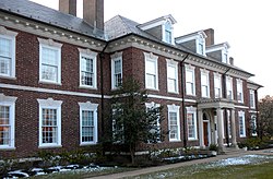
Main Office of Lukens Steel
As Lukens Steel grew so did Coatesville, eventually becoming known as the "Pittsburgh of the East."[4] By the beginning of the 20th century the population had grown to 6,000, attracting immigrants from Eastern and Southern Europe to its industrial jobs, as well as both black and white migrants from the rural South. Tensions rose in the city as the population rapidly became more diverse.
In August 1911, steelworker Zachariah Walker was lynched in Coatesville; he had left his wife and children in Virginia while seeking better work. This African-American man was accused of killing Deputy Constable/Coal and Iron Policeman Edgar Rice, a popular figure in town. Walker claimed self-defense and was hospitalized after his arrest. He was dragged from the hospital and burned to death in front of a mob of hundreds in a field south of the city. Fifteen men and teenage boys were indicted, but all were acquitted at trials. The lynching was the last in Pennsylvania and is said to have left a permanent stain on the city's image.[4][9]
Walker's murder was investigated by the National Association for the Advancement of Colored People (NAACP), which called for an end to lynching nationwide.[4] Pennsylvania passed a state anti-lynching law in 1923. But, even after passage of an anti-lynching House bill in the 1920s, no federal law was passed because of the power of the Democratic southern bloc in the Senate. At that time, it represented only white southerners; African Americans had been disfranchised in the South since the turn of the century.
Racial violence was spreading all across America during the Red Summer of 1919 and the local African-American community was on edge. On July 8, 1919, the black community of Coatesville formed a large armed protection group to prevent the rumoured lynching of a rape suspect. When the armed group surrounded the jail to prevent the attack, they learned that there was no suspect and no lynch mob.
In 1929, the Coatesville VA Medical Center was built with an original mission to provide neuropsychiatric care to veterans. In 2013, the Medical Center, with its distinctive architecture of Colonial Revival and Classical Revival, was listed on the National Register of Historic Places. The Medical Center now provides a range of health care services to more than 19,000 Veterans in Pennsylvania and Delaware.[10]
The school system expanded to keep up and the religious community became more diverse, with Roman Catholic churches founded and Beth Israel Congregation, one of Chester County's few synagogues. In 1932 there were a total of 22 churches of various denominations in the city.
After World War II the steel industry began a long decline, but in the 1960s Lukens Steel was still the largest employer in Chester County, with over 10,000 workers. It finally started to restructure due to industry changes, was sold several times, and its workers were reduced in number to 5,000 and eventually to 2,000.[4]
21st century
Episcopal Church of the Trinity, 323 East Lincoln Highway
Since the turn of the century, Coatesville has invested in redevelopment, encouraging private projects. It has torn down public housing and encouraged new single family and townhouse developments. A new Marriott Courtyard hotel, built along Route 82 on the outskirts of Coatesville, opened in May 2012.[11]
The redevelopment plans have generated controversy.[12] The city was involved in a 5-year eminent domain dispute with a local landowner in neighboring Valley Township. It was resolved without the need to seize the property, but displeasure with the events resulted in the city voters turning out four incumbent city councilpersons in the November 2005 general elections. Two of the four new councilpersons were ordained Pentecostal and Methodist ministers, respectively. The city council fired the city solicitor, and accepted the resignation of the city manager (who had negotiated with the Valley Township landowner). The assistant manager, police chief, and city treasurer also resigned.
A series of arsons took place in the city from 2007 to early 2009.[13] A December 2008 fire at a Strode Avenue home resulted in the death of Irene Kempest, an 83-year-old World War II Holocaust survivor. A fire the following month on the 300 block of Fleetwood Street burned 17 row houses, causing $2 million in damage and leaving dozens of people homeless. By March 2009, police had arrested six suspects in the fires. A total of nearly 70 fires occurred during this period. On June 8, 2010 one man, pleading no-contest due to mental illness, was sentenced to a 60-year prison sentence for five of the fires, one of which resulted in Kempest's death.[14] Another man pleaded guilty to the Fleetwood Street fire and eight others, receiving a sentence of 12.5 to 25 years with an order to pay $2.5 million in restitution.[15] Twenty of the nearly 70 fires over the two-year span remain unsolved.[14]
According to the U.S. Census Bureau, the city has a total area of 1.9 square miles (4.9km2), of which 0.53% is water.
Climate
Coatesville has a typical Northeast climate with cold, snowy winters and hot humid summers. It has a hot-summer humid continental climate (Dfa) and the hardiness zone is 6b bordering 7a.
Coatesville city, Pennsylvania – Racial and ethnic composition Note: the US Census treats Hispanic/Latino as an ethnic category. This table excludes Latinos from the racial categories and assigns them to a separate category. Hispanics/Latinos may be of any race.
As of the 2020 census, Coatesville had a population of 13,350. The median age was 31.5 years. 30.9% of residents were under the age of 18 and 10.4% of residents were 65 years of age or older. For every 100 females there were 90.9 males, and for every 100 females age 18 and over there were 85.9 males age 18 and over.[26][27]
100.0% of residents lived in urban areas, while 0.0% lived in rural areas.[28]
There were 4,747 households in Coatesville, of which 39.6% had children under the age of 18 living in them. Of all households, 27.3% were married-couple households, 22.3% were households with a male householder and no spouse or partner present, and 41.7% were households with a female householder and no spouse or partner present. About 29.0% of all households were made up of individuals and 10.1% had someone living alone who was 65 years of age or older.[26]
There were 5,221 housing units, of which 9.1% were vacant. The homeowner vacancy rate was 1.3% and the rental vacancy rate was 7.9%.[26]
There were 4,498 households, out of which 36.5% had children under the age of 18 living with them, 28.3% were married couples living together, 27.7% had a female householder with no spouse present, 8.2% had a male householder with no spouse present, and 35.8% were non-families. 42.4% of all households had individuals under 18 living in them, and 19.5% had someone living alone who was 65 years of age or older. The average household size was 2.86 and the average family size was 3.46.
In the city, the population was spread out, with 30.4% under the age of 18. The median age was 31 years. The population was 50.6% female and 49.4% male.
Coatesville had 4,998 housing units, of which 90.2% were occupied. Of the occupied housing units, 37.5% were owner-occupied.
2000 census
In 2000, the median income for a household in the city was $29,912, and the median income for a family was $36,375. Males had a median income of $31,782 versus $24,774 for females. The per capita income for the city was $14,079. About 18.3% of families and 22.1% of the population were below the poverty line, including 28.9% of those under age 18 and 15.9% of those age 65 or over.
Government
The city is a third class city and is governed by a Council–manager form of government. There are seven council members, one for each of the five voting wards and two elected at-large.
As of 2018, there were 31.15 miles (50.13km) of public roads in Coatesville, of which 6.50 miles (10.46km) were maintained by Pennsylvania Department of Transportation (PennDOT) and 24.65 miles (39.67km) were maintained by the city.[31]
The main east–west road serving Coatesville is US 30, which bypasses the city to the north on a freeway and provides access to Lancaster to the west and Philadelphia to the east. US 30 Business runs east–west through the heart of the city on Lincoln Highway. PA 82 is the main north–south road in Coatesville, running along Strode Avenue, Lincoln Highway, and North 1st Avenue, and heading north to Elverson and south to Kennett Square. PA 340 passes to the north of the city while PA 372 begins at PA 82 in Coatesville and heads west on Valley Road to Parkesburg and Atglen.[32]
Coatesville Amtrak station
A general aviation airport, Chester County G. O. Carlson Airport, which allows private and corporate aircraft to easily access the town, is located about 3 miles (4.8km) west in neighboring Valley Township. The nearest airport with commercial air service is the Philadelphia International Airport in Philadelphia.
Coatesville is served by the Coatesville Amtrak Station, which serves Keystone Service trains along the Keystone Corridor.[33] Until 1997, the station also served SEPTA's R5 regional rail line from Philadelphia, which is now the Paoli/Thorndale Line and ends east of Coatesville in Thorndale. On March 7, 2019, it was announced that SEPTA service would return to Coatesville in the future with a new station to be built near the current Amtrak station that would serve an extension of the Paoli/Thorndale Line service.[34] On July 13, 2021, the Pennsylvania Department of Transportation announced that it was soliciting bids for the construction of the new station, to be built at Third Avenue and Fleetwood Street, with construction to be completed by 2025.[35] The Reading Company formerly had its own passenger station on the Wilmington and Northern Branch, located at the northwest corner of Lincoln Avenue and 1st Avenue.[36]
↑Rellahan, Michael P. (September 18, 2010). "Serial arsonist pleads guilty". Daily Local News (Chester Co., PA). dailylocal.com. Archived from the original on September 28, 2012. Retrieved September 4, 2011.
↑Dennis Downey, with Raymond Hyser, Coatesville and the Lynching of Zachariah Walker (revised 20th anniversary edition, 2011)
Further reading
Rodriguez, Ismael Jr. (August 2020). "Local Citizen Helps VFW Post Commemorate Its Namesake". VFW Magazine. Vol.107, no.10. Kansas City, Mo.: Veterans of Foreign Wars of the United States. pp.38–40. ISSN0161-8598. A history enthusiast delved deep into the past to uncover the friendship that forged and chartered a Pennsylvania VFW Post more than a century ago.
This page is based on this Wikipedia article Text is available under the CC BY-SA 4.0 license; additional terms may apply. Images, videos and audio are available under their respective licenses.