South Coventry Township | |
---|---|
Coordinates: 40°11′07″N75°40′43″W / 40.18528°N 75.67861°W | |
Country | United States |
State | Pennsylvania |
County | Chester |
Area | |
• Total | 7.60 sq mi (19.68 km2) |
• Land | 7.54 sq mi (19.52 km2) |
• Water | 0.06 sq mi (0.15 km2) |
Elevation | 650 ft (200 m) |
Population (2010) | |
• Total | 2,604 |
• Estimate (2016) [2] | 2,603 |
• Density | 345.32/sq mi (133.34/km2) |
Time zone | UTC-5 (EST) |
• Summer (DST) | UTC-4 (EDT) |
Area code(s) | 610 |
FIPS code | 42-029-72088 |
School district | Owen J. Roberts |
Website | www |
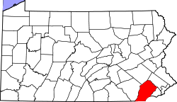
South Coventry Township is a township in Chester County, Pennsylvania, United States. The population was 2,604 at the 2010 census.
The township derives its name from Coventry, England, the native home of an early settler. [3]
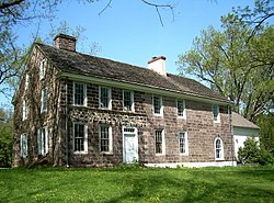
Coventry Hall, Coventryville Historic District, Simon Meredith House, Stephen Meredith House, Nathan Michener House, and Townsend House are listed on the National Register of Historic Places. [4]
According to the United States Census Bureau, the township has a total area of 7.5 square miles (19 km2), all land. The township is located in the Hopewell Big Woods.
There are three main historical and unincorporated villages within the township: Bucktown, Coventryville, and Pughtown.
It is the home of Owen J. Roberts School District's main campus, located at the intersection of Route 23 and Route 100.
Census | Pop. | Note | %± |
---|---|---|---|
1930 | 589 | — | |
1940 | 679 | 15.3% | |
1950 | 863 | 27.1% | |
1960 | 1,212 | 40.4% | |
1970 | 1,518 | 25.2% | |
1980 | 1,556 | 2.5% | |
1990 | 1,682 | 8.1% | |
2000 | 1,895 | 12.7% | |
2010 | 2,604 | 37.4% | |
2020 | 2,796 | 7.4% | |
[5] |
At the 2010 census, the township was 95.5% non-Hispanic White, 0.5% Black or African American, 0.2% Native American, 1.0% Asian, and 1.2% were two or more races. 1.7% of the population were of Hispanic or Latino ancestry. [6]
At the 2000 census, [7] there were 1,895 people, 690 households and 529 families living in the township. The population density was 253.6 inhabitants per square mile (97.9/km2). There were 721 housing units at an average density of 96.5 per square mile (37.3/km2). The racial makeup of the township was 98.47% White, 0.63% African American, 0.16% Native American, 0.11% Asian, 0.21% from other races, and 0.42% from two or more races. Hispanic or Latino of any race were 0.69% of the population.
There were 690 households, of which 34.5% had children under the age of 18 living with them, 68.8% were married couples living together, 4.9% had a female householder with no husband present, and 23.3% were non-families. 18.6% of all households were made up of individuals, and 7.1% had someone living alone who was 65 years of age or older. The average household size was 2.69 and the average family size was 3.09.
Age distribution was 26.0% under the age of 18, 4.5% from 18 to 24, 30.8% from 25 to 44, 24.1% from 45 to 64, and 14.6% who were 65 years of age or older. The median age was 40 years. For every 100 females, there were 98.4 males. For every 100 females age 18 and over, there were 96.5 males.
The median household income was $62,857 and the median family income was $75,157. Males had a median income of $51,063 versus $33,482 for females. The per capita income for the township was $28,956. About 3.2% of families and 3.7% of the population were below the poverty line, including 1.0% of those under age 18 and 13.1% of those age 65 or over.
The township is in the Owen J. Roberts School District. [8] Owen J. Roberts High School is the zoned comprehensive high school.
As of 2019, there were 26.43 miles (42.53 km) of public roads in South Coventry Township, of which 9.12 miles (14.68 km) were maintained by the Pennsylvania Department of Transportation (PennDOT) and 17.31 miles (27.86 km) were maintained by the township. [9]
Pennsylvania Route 23 and Pennsylvania Route 100 are the numbered roads serving South Coventry Township. PA 23 follows Ridge Road along an east-west alignment through the central portion of the township. PA 100 follows Pottstown Pike along a north-south alignment across the eastern portion of the township.
Ruscombmanor Township is a township in Berks County, Pennsylvania, United States. The population was 4,112 at the 2010 census.
Charlestown Township is a township in Chester County, Pennsylvania, United States. The population was 6,003 at the 2020 census.
Chesterbrook is a census-designated place (CDP) in Chester County, Pennsylvania, United States. It is located within the Philadelphia metropolitan area and just south of Valley Forge National Historical Park. The population was 4,589 at the 2010 census.
East Bradford Township is a township in Chester County, Pennsylvania, United States. The population was 10,308 at the 2020 census.
East Coventry Township is a township in Chester County, Pennsylvania, United States. The population was 7,068 at the 2020 census.
East Nantmeal Township is a township in Chester County, Pennsylvania, United States. The population was 1,803 at the 2010 census. Along with West Nantmeal Township, it was originally part of a single Nantmeal Township, which was divided in 1739.
Elk Township is a township in Chester County, Pennsylvania, United States. The population was 1,681 at the 2010 census.
Kenilworth is a census-designated place (CDP) in North Coventry Township, Chester County, Pennsylvania, United States. The population was 2,148 at the 2020 census.
Londonderry Township is a township in Chester County, Pennsylvania, United States. The population was 2,149 at the 2010 census.
New London Township is a township that is located in Chester County, Pennsylvania, United States. It was the birthplace of U.S. Founding Father Thomas McKean.
Newlin Township is a township in Chester County, Pennsylvania, United States. The population was 1,285 at the 2010 census.
North Coventry Township is a township in Chester County, Pennsylvania, United States. The population was 7,866 at the 2010 census.
Schuylkill Township is a township in Chester County, Pennsylvania, United States. It contains the village of Valley Forge. The population was 8,516 at the 2010 census.
South Pottstown is a community in North Coventry Township, Chester County in the U.S. state of Pennsylvania. It is defined by the U.S. Census Bureau as a census-designated place (CDP) for statistical purposes and does not have any legal status as a separately incorporated municipality. It is a part of the Pottstown urban area. The population was 2,081 at the 2010 census.
Valley Township is a township in Chester County, Pennsylvania, United States. The population was 6,794 at the 2010 census.
Warwick Township is a township in Chester County, Pennsylvania, United States. The population was 2,507 at the 2010 census.
West Brandywine Township is a township that is located in Chester County, Pennsylvania, United States. The population was 7,394 at the time of the 2010 census.
West Nantmeal Township is a township in Chester County, Pennsylvania, United States. The population was 2,251 at the 2020 census. It and East Nantmeal Township were originally part of a single Nantmeal Township, which was divided in 1739.
West Vincent Township is a township in Chester County, Pennsylvania, United States. The population was 4,567 at the 2010 census.
West Pottsgrove Township is a township in Montgomery County, Pennsylvania, United States. The population was 3,874 at the 2010 census.