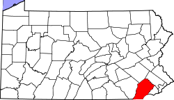
Newlin Township | |
---|---|
Coordinates: 39°55′49″N75°44′25″W / 39.93028°N 75.74028°W | |
Country | United States |
State | Pennsylvania |
County | Chester |
Area | |
• Total | 12.12 sq mi (31.39 km2) |
• Land | 11.97 sq mi (31.02 km2) |
• Water | 0.15 sq mi (0.38 km2) |
Elevation | 220 ft (70 m) |
Population (2010) | |
• Total | 1,285 |
1,351 | |
• Density | 112.82/sq mi (43.56/km2) |
Time zone | UTC-5 (EST) |
• Summer (DST) | UTC-4 (EDT) |
Area code(s) | 610 |
FIPS code | 42-029-53784 |
Newlin Township is a township in Chester County, Pennsylvania, United States. The population was 1,285 at the 2010 census.
Newlin Township was the hometown of explorer Josiah Harlan and Lenape healer Hannah Freeman. Physician and Civil War nurse Hettie Kersey Painter grew up in Newlin. [3] William Baldwin, the botanist, was born there on March 29, 1779. [4] [5]
The township was named for Nicholas Newlin (1630–1699), who received a deed from William Penn. In 1704, his son Nathaniel (1663–1729) and his wife Mary built a water-powered gristmill along the West Branch of Chester Creek. The Newlin Grist Mill is located in Glen Mills, now in Delaware County. [6]
The Embreeville Historic District, Green Valley Historic District, Harlan House, Hayes Homestead, Hayes Mill House, Jacob Hayes House, House at Upper Laurel Iron Works, Indian Deep Farm, Marlborough Village Historic District, Mountain Meadow Farm, Northbrook Historic District, Spruce Grove School, and Joseph Young House are listed on the National Register of Historic Places. [7]
According to the United States Census Bureau, the township has a total area of 12.0 square miles (31 km2), of which 0.04 square miles (0.10 km2), or 0.25%, is water.
At the 2010 census, the township was 95.0% non-Hispanic White, 0.6% Black or African American, 0.9% Asian, and 0.6% were two or more races. 2.9% of the population were of Hispanic or Latino ancestry. [8]
As of the census [9] of 2000, there were 1,150 people, 429 households, and 335 families living in the township. The population density was 96.0 inhabitants per square mile (37.1/km2). There were 446 housing units at an average density of 37.2 per square mile (14.4/km2). The racial makeup of the township was 97.04% White, 0.78% African American, 0.43% Asian, 0.17% Pacific Islander, 0.70% from other races, and 0.87% from two or more races. Hispanic or Latino of any race were 2.00% of the population.
There were 429 households, out of which 33.8% had children under the age of 18 living with them, 69.9% were married couples living together, 5.6% had a female householder with no husband present, and 21.9% were non-families. 15.4% of all households were made up of individuals, and 3.3% had someone living alone who was 65 years of age or older. The average household size was 2.68 and the average family size was 3.00.
In the township the population was spread out, with 23.1% under the age of 18, 5.3% from 18 to 24, 27.5% from 25 to 44, 33.5% from 45 to 64, and 10.6% who were 65 years of age or older. The median age was 42 years. For every 100 females, there were 102.1 males. For every 100 females age 18 and over, there were 104.2 males.
The median income for a household in the township was $68,828, and the median income for a family was $75,241. Males had a median income of $48,250 versus $37,885 for females. The per capita income for the township was $36,804. About 2.4% of families and 3.5% of the population were below the poverty line, including 0.7% of those under age 18 and 5.0% of those age 65 or over.
Newlin Township lies within the Unionville-Chadds Ford School District
As of 2019, there were 31.51 miles (50.71 km) of public roads in Newlin Township, of which 12.79 miles (20.58 km) were maintained by the Pennsylvania Department of Transportation (PennDOT) and 18.72 miles (30.13 km) were maintained by the township. [11]
Pennsylvania Route 162 and Pennsylvania Route 842 are the numbered highways serving Newlin Township. PA 162 follows Embreeville Road along a north-south alignment through the middle of the township. PA 842 follows Unionville Wawaset Road along a southwest-northeast alignment through the southeastern part of the township.
Birmingham Township is a township in Chester County, Pennsylvania, United States. The population was 4,081 at the 2020 census.
East Bradford Township is a township in Chester County, Pennsylvania, United States. The population was 10,335 at the 2020 census.
East Fallowfield Township is a township in Chester County, Pennsylvania, United States. The population was 7,626 at the 2020 census.
East Marlborough Township is a township in Chester County, Pennsylvania, United States. The population was 7,305 at the 2020 census. East Marlborough and West Marlborough townships were carved out of the larger Marlborough Township in 1729. The township is home to many Penn Oak trees, trees that were in existence when William Penn explored the area.
Elk Township is a township in Chester County, Pennsylvania, United States. The population was 1,681 at the 2010 census.
Highland Township is a township in Chester County, Pennsylvania, United States. It was founded in 1853 when West Fallowfield Township was divided and the division with the higher elevation was named Highland Township. The population was 1,272 at the 2010 census.
London Britain Township is a township in Chester County, Pennsylvania, United States. The population was 3,139 at the 2010 census. White Clay Creek Preserve is a Pennsylvania state park in London Britain Township, along White Clay Creek.
New Garden Township is a township in Chester County, Pennsylvania, United States, which was organized in 1714. The population was 11,363 at the 2020 census.
North Coventry Township is a township in Chester County, Pennsylvania, United States. The population was 7,866 at the 2010 census.
Penn Township is a township that is located in Chester County, Pennsylvania, United States. It is home to the Nursery Capital of Pennsylvania and was the site of Sunset Park, one of country music's most popular venues.
Pennsbury Township is a township in Chester County, Pennsylvania, United States. The population was 3,604 at the 2010 census.
Pocopson Township is a township in Chester County, Pennsylvania, United States. The population was 4,582 at the 2010 census.
Schuylkill Township is a township in Chester County, Pennsylvania, United States. It contains the village of Valley Forge. The population was 8,516 at the 2010 census.
Wallace Township is a township in Chester County, Pennsylvania, United States. The population was 3,458 at the 2010 census.
Warwick Township is a township in Chester County, Pennsylvania, United States. The population was 2,507 at the 2010 census.
West Bradford Township is a township that is located in Chester County, Pennsylvania, United States. The population was 14,706 at the time of the 2020 census.
West Marlborough Township is a township in Chester County, Pennsylvania, United States. The population was 814 at the 2010 census. East Marlborough and West Marlborough townships were carved out of the larger Marlborough Township in 1729.
West Nottingham Township is a township in Chester County, Pennsylvania, United States. The population was 2,722 at the 2010 census.
Concord Township is a township in Delaware County, Pennsylvania, United States. The population was 17,231 at the 2010 census. It contains the unincorporated communities of Concordville and Glen Mills.
Hatfield Township is a township in Montgomery County, Pennsylvania, United States. The population was 17,249 at the 2010 census. It is part of the North Penn Valley region which is centered around the borough of Lansdale.