Chesterville, Pennsylvania

Last updated
Chesterville, Pennsylvania
Unincorporated community
USA Pennsylvania location map.svg
Red pog.svg
Chesterville
Usa edcp location map.svg
Red pog.svg
Chesterville
Coordinates: 39°46′40″N75°48′39″W / 39.77778°N 75.81083°W / 39.77778; -75.81083 Coordinates: 39°46′40″N75°48′39″W / 39.77778°N 75.81083°W / 39.77778; -75.81083
Country United States
State Pennsylvania
County Chester
Township Franklin
Elevation
410 ft (120 m)
Time zone UTC-5 (Eastern (EST))
  Summer (DST) UTC-4 (EDT)
Area code(s) 610 and 484
GNIS feature ID1203263 [1]

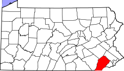
Chesterville is an unincorporated community in Franklin Township in Chester County, Pennsylvania, United States. Chesterville is located at the intersection of Pennsylvania Route 841, Chesterville Road, and North Creek Road. [2]

Related Research Articles

<span class="mw-page-title-main">Elk Township, Chester County, Pennsylvania</span> Township in Pennsylvania, United States

Elk Township is a township in Chester County, Pennsylvania, United States. The population was 1,681 at the 2010 census.

<span class="mw-page-title-main">Franklin Township, Chester County, Pennsylvania</span> Township in Pennsylvania, United States

Franklin Township is a township in Chester County, Pennsylvania. The population was 4,352 at the 2010 census.

<span class="mw-page-title-main">New London Township, Chester County, Pennsylvania</span> Township in Pennsylvania, United States

New London Township is a township in Chester County, Pennsylvania, United States. The population was 5,810 at the 2020 census. It was the birthplace of U.S. Founding Father Thomas McKean.

<span class="mw-page-title-main">West Chester, Pennsylvania</span> Borough in Pennsylvania, United States

West Chester is a borough and the county seat of Chester County, Pennsylvania, United States. Located within the Philadelphia metropolitan area, the borough had a population of 18,461 at the 2010 census. West Chester is the mailing address for most of its neighboring townships. When calculated by mailing address, the population as of the 2010 U.S. Census was 108,696, which would make it the 10th largest city by mailing address in the state of Pennsylvania.

<span class="mw-page-title-main">White Clay Creek</span> River in Delaware, United States

White Clay Creek is an 18.5-mile-long (29.8 km) tributary of the Christina River in southern Pennsylvania and northern Delaware in the United States. It is renowned for its scenic character and is largely federally protected.

<span class="mw-page-title-main">U.S. Route 322</span> Highway in the United States

U.S. Route 322 is a 494 mi (795.0 km) long, east–west United States Highway, traversing Ohio, Pennsylvania, and New Jersey. The road is a spur of US 22 and one of the original highways from 1926. A portion of it at one time was concurrent with the Lakes-to-Sea Highway.

<span class="mw-page-title-main">Chester Township, Morrow County, Ohio</span> Township in Ohio, United States

Chester Township is one of the sixteen townships of Morrow County, Ohio, United States. The 2010 census found 1,872 people in the township, 228 of whom lived in the village of Chesterville.

<span class="mw-page-title-main">Maryland Route 290</span> Highway in Maryland

Maryland Route 290 is a state highway in the U.S. state of Maryland. The highway runs 17.20 miles (27.68 km) from MD 300 at Dudley Corners north to MD 299 near Sassafras. MD 290 roughly parallels U.S. Route 301, which it intersects twice, as it connects the communities of Crumpton in northern Queen Anne's County and Chesterville and Galena in eastern Kent County. The portion of the route in Queen Anne's County was constructed as MD 301 in the early to mid-1920s. In Kent County, a portion south of Galena was built in the late 1910s and extended south to the Chester River in the late 1920s. MD 290 assumed the course of MD 301 in 1940 to avoid a number conflict with US 301. The Galena–Sassafras section of the highway was built in the late 1940s. MD 290 was reconstructed in Queen Anne's County and from south of Galena to Sassafras in the mid- to late 1950s. The highway's interchanges with US 301 were built when the U.S. Highway's course was constructed in the mid-1950s.

<span class="mw-page-title-main">Maryland Route 291</span> Highway in Maryland

Maryland Route 291 (MD 291) is a state highway in the U.S. state of Maryland. The highway runs 18.34 miles (29.52 km) from MD 20 in Chestertown east to the Delaware state line east of Millington, where the highway continues east as Delaware Route 6 (DE 6). MD 291 parallels the Chester River along the southern edge of Kent County and connects Chestertown with U.S. Route 301 (US 301). The highway follows much of what was originally MD 447, which was constructed between US 213 in Chestertown and MD 290 at Chesterville around 1930. MD 291 itself was built east of Millington around 1930. The highway was extended west toward Chesterville in the early 1930s, but it was not complete to MD 290 until the late 1940s. MD 291 was extended west to US 213 along a partially new alignment in the early 1960s, superseding MD 447. MD 291 was reconstructed along its entire length between the mid-1960s and mid-1970s, and it reached its present western terminus at MD 20 in 1969.

<span class="mw-page-title-main">Pennsylvania Route 841</span> State highway in Chester County, Pennsylvania, US

Pennsylvania Route 841 is a state highway in Chester County, Pennsylvania. The route runs from the Maryland border in the community of Lewisville in Elk Township, where the road continues as Maryland Route 213, north to PA 82 in the community of Doe Run in West Marlborough Township. The route heads through rural areas of southwestern Chester County on a two-lane undivided road. PA 841 passes through West Grove, where it has an interchange with U.S. Route 1. PA 841 was first assigned to an unpaved road running from Springdell to PA 82 in 1928. The route was extended south to its current terminus in 1937 and was completely paved by 1940.

Parker Ford is an unincorporated community in East Coventry Township, Chester County, Pennsylvania, United States. Maps show it at the intersection of Pennsylvania Route 724 and Bethel Church Road/Linfield Road. Linfield Road crosses the Schuylkill River to Linfield, an unincorporated village in Limerick Township, Montgomery County.

Chesterville is an unincorporated community in eastern Colorado County, in the U.S. state of Texas. It is located in a farming region northeast of Eagle Lake at the junction of Farm to Market Road 1093 (FM 1093) and Farm to Market Road 2764 (FM 2764). A large grain storage facility is a significant landmark in the area.

Springdell is an unincorporated community in West Marlborough Township in Chester County, Pennsylvania, United States. Springdell is located at the intersection of Pennsylvania Route 841 and Spring Dell Road.

Pocopson is an unincorporated community in Pocopson Township in Chester County, Pennsylvania, United States. Pocopson is located at the intersection of Pennsylvania Route 926 and Pocopson Road.

Devault is an unincorporated community in Charlestown Township in Chester County, Pennsylvania, United States. Devault is located at the intersection of Pennsylvania Route 29, Phoenixville Pike, and Charlestown Road.

Lenape is an unincorporated community in Pocopson Township in Chester County, Pennsylvania, United States. Lenape is centered on the intersection of Pennsylvania Route 52 and Pocopson Road, west of the Brandywine Creek.

Mendenhall is an unincorporated community in Kennett Township in Chester County, Pennsylvania, United States. Mendenhall is located at the intersection of Pennsylvania Route 52 and Hillendale Road.

Kelton is an unincorporated community in Penn Township in Chester County, Pennsylvania, United States. Kelton is located at the intersection of Pennsylvania Route 796 and Kelton Road.

Brandamore is an unincorporated community in West Brandywine Township in Chester County, Pennsylvania, United States. Brandamore is located at the intersection of Hibernia Road and Brandamore Road, north of Coatesville.

Suplee is an unincorporated community in Honey Brook Township in Chester County, Pennsylvania, United States. Suplee is located along Suplee Road, east of Honey Brook.

References

  1. "Chesterville". Geographic Names Information System . United States Geological Survey, United States Department of the Interior.
  2. Chester County, Pennsylvania Highway Map (PDF) (Map). PennDOT. 2012. Retrieved August 22, 2013.[ permanent dead link ]