Unionville, Pennsylvania | |
|---|---|
 House in the historic district | |
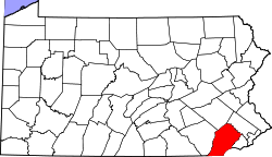
 Location in Chester County and the U.S. state of Pennsylvania | |
| Coordinates: 39°53′51.9″N75°43′49.5″W / 39.897750°N 75.730417°W | |
| Country | United States |
| State | Pennsylvania |
| County | Chester |
| Township | East Marlborough |
| Area | |
• Total | 2.24 km2 (0.863 sq mi) |
| • Land | 2.21 km2 (0.855 sq mi) |
| • Water | 0.021 km2 (0.008 sq mi) |
| Elevation | 145 m (476 ft) |
| Population | |
• Total | 577 |
| • Density | 261/km2 (675/sq mi) |
| Time zone | UTC-5 (EST) |
| • Summer (DST) | UTC-4 (EDT) |
| ZIP code | 19375 |
| Area codes | 610 and 484 |
| FIPS code | 4278624 [1] |
| GNIS feature ID | 2812903 [2] |
Unionville is an unincorporated community and census-designated place in East Marlborough Township in southern Chester County, Pennsylvania, United States. It was originally known as Jacksonville. [4] The Unionville Village Historic District was added to the National Register of Historic Places in 1979. [5] As of 2020, the CDP has a population of 577. [6]


