Chesterbrook, Pennsylvania

Last updated

Chesterbrook
Chesterbrook2.jpg
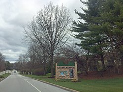
Chesterbrook entrance
Chester County Pennsylvania incorporated and unincorporated areas Chesterbrook highlighted.svg
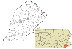
Location in Chester County and the U.S. state of Pennsylvania.
Coordinates: 40°04′28″N75°27′18″W / 40.07444°N 75.45500°W / 40.07444; -75.45500
CountryUnited States
StatePennsylvania
County Chester
Township Tredyffrin
Area
[1]
  Total1.56 sq mi (4.05 km2)
  Land1.56 sq mi (4.03 km2)
  Water0.01 sq mi (0.02 km2)
Elevation
161 ft (49 m)
Population
 (2020) [2]
  Total5,610
  Density3,600.77/sq mi (1,390.54/km2)
Time zone UTC-5 (EST)
  Summer (DST) UTC-4 (EDT)
ZIP code
19087
Area code(s) 610 and 484
FIPS code 42-13216

Chesterbrook is a census-designated place (CDP) in Chester County, Pennsylvania, United States. It is located within the Philadelphia metropolitan area and just south of Valley Forge National Historical Park. The population was 4,589 at the 2010 census.

Contents

Chesterbrook is a development located in Tredyffrin Township which is located in Chester County. It is not a town, unincorporated or otherwise. It is in the Chester County side of Wayne. Wayne exists primarily in Delaware County, but also has a small portion of Montgomery County, all within the zip code of 19087.

Chesterbrook is a development which started when the Fox Companies purchased land (two large parcels), and, due to the Municipalities Planning Code of 1969 of the Commonwealth of Pennsylvania, the development was approved in 1978.

Geography

According to the U.S. Census Bureau, Chesterbrook has a total area of 1.6 square miles (4.1 km2), all land. Chesterbrook is located approximately 23 miles from Philadelphia.

Demographics

Historical population
CensusPop.Note
2000 4,625
2010 4,589−0.8%
2020 5,61022.2%
[3] [2]

At the 2000 census there were 4,625 people, 2,356 households, and 1,175 families living in the CDP. The population density was 2,871.7 inhabitants per square mile (1,108.8/km2). There were 2,413 housing units at an average density of 1,498.3 per square mile (578.5/km2). The racial makeup of the CDP was 89.71% White, 1.84% African American, 0.17% Native American, 7.07% Asian, 0.52% from other races, and 0.69% from two or more races. Hispanic or Latino of any race were 2.03%. [4]

There were 2,356 households, 20.4% had children under the age of 18 living with them, 39.2% were married couples living together, 8.3% had a female householder with no husband present, and 50.1% were non-families. 42.1% of households were made up of individuals, and 7.2% were one person aged 65 or older. The average household size was 1.96 and the average family size was 2.71.

The age distribution was 17.3% under the age of 18, 4.0% from 18 to 24, 38.4% from 25 to 44, 29.3% from 45 to 64, and 10.9% 65 or older. The median age was 40 years. For every 100 females, there were 80.7 males. For every 100 females age 18 and over, there were 79.2 males.

The median household income was $80,792 and the median family income was $90,872. Males had a median income of $68,906 versus $47,348 for females. The per capita income for the CDP was $51,859. About 1.4% of families and 2.1% of the population were below the poverty line, including 2.8% of those under age 18 and none of those age 65 or over.

Economy

Education

The CDP is within the Tredyffrin/Easttown School District. [5] Most areas of the CDP are zoned to Valley Forge Elementary School while some are zoned to New Eagle Elementary School. [6] The district has two middle schools, Valley Forge and Tredyffrin/Easttown. All residents are zoned to Valley Forge Middle School and Conestoga High School.

Infrastructure

Transportation

Chesterbrook Boulevard serves as the main road through Chesterbrook, heading south to an interchange with the U.S. Route 202 freeway and an intersection with Pennsylvania Route 252 at Swedesford Road and heading east to another intersection with PA 252 at Valley Forge Road. [7] Chesterbrook is served by SEPTA Suburban Division bus routes with the Route 124 bus connecting the community to the King of Prussia Transit Center at the King of Prussia Mall and Center City Philadelphia [8] and the Route 205 bus connecting the community during peak weekday hours to the Paoli station along SEPTA Regional Rail's Paoli/Thorndale Line. [9]

Related Research Articles

<span class="mw-page-title-main">Warminster Heights, Pennsylvania</span> Census-designated place in Pennsylvania, United States

Warminster Heights is a census-designated place and part of Warminster Township in Bucks County, Pennsylvania, United States. It is located near the eastern border of Hatboro in Montgomery County. The population was 4,124 at the 2010 census.

<span class="mw-page-title-main">Charlestown Township, Pennsylvania</span> Township in Pennsylvania, United States

Charlestown Township is a township in Chester County, Pennsylvania, United States. The population was 6,003 at the 2020 census.

<span class="mw-page-title-main">East Whiteland Township, Pennsylvania</span> Township in Pennsylvania, United States

East Whiteland Township is a township in Chester County, Pennsylvania, United States. The population was 13,913 at the 2020 Census. Mailing addresses associated with East Whiteland include Malvern, Frazer, and a small area of Exton.

<span class="mw-page-title-main">Easttown Township, Pennsylvania</span> Township in Pennsylvania, United States

Easttown Township is a township in Chester County, Pennsylvania, United States. The population was 10,984 at the 2020 census. The township, which lies in the western half of Philadelphia's Main Line suburbs, is comprised predominantly of parts of two unincorporated areas: Devon and Berwyn. A small portion of the township has a Paoli address.

<span class="mw-page-title-main">Exton, Pennsylvania</span> Census-designated place in Pennsylvania, United States

Exton is a census-designated place (CDP) in West Whiteland Township in Chester County, Pennsylvania, United States. Its population was 5,622 at the 2020 census. The Exton Square Mall and Main Street at Exton are both located within Exton along with several other shopping centers, making Exton the major shopping district in Chester County.

<span class="mw-page-title-main">Malvern, Pennsylvania</span> Borough in Pennsylvania, United States

Malvern is a borough in Chester County, Pennsylvania, United States. Malvern is the terminus of the Main Line, a series of highly affluent Philadelphia suburbs located along the railroad tracks of the Pennsylvania Railroad. It is 19.4 miles (31.2 km) west of Philadelphia. The population was 3,419 at the 2020 census.

<span class="mw-page-title-main">Paoli, Pennsylvania</span> Census-designated place in Pennsylvania, United States

Paoli is a census-designated place (CDP) in Chester County near Philadelphia, Pennsylvania, United States. It is situated in portions of two townships: Tredyffrin and Willistown. At the 2020 census, it had a total population of 6,002.

<span class="mw-page-title-main">Thorndale, Pennsylvania</span> Census-designated place in Pennsylvania, United States

Thorndale is a census-designated place in Caln Township, Chester County, Pennsylvania, United States. The population was 3,407 at the 2010 census.

<span class="mw-page-title-main">Tredyffrin Township, Pennsylvania</span> Township in Pennsylvania, United States

Tredyffrin Township is a township located in eastern Chester County, Pennsylvania, United States. The population was 29,332 at the 2010 census.

<span class="mw-page-title-main">Willistown Township, Pennsylvania</span> Township in Pennsylvania, United States

Willistown Township is a township in Chester County, Pennsylvania, United States. The population was 10,497 at the 2010 census. At the 1860 census, the population of Willistown was 1,521, and in 1980 it was 8,269.

<span class="mw-page-title-main">Ridley Township, Pennsylvania</span> Township in Pennsylvania, United States

Ridley Township is a township in Delaware County, Pennsylvania, United States. The population was 30,768 at the 2010 census. Ridley Township contains the (CDPs) of Folsom and Woodlyn, along with the unincorporated communities of Crum Lynne and Holmes and a portion of Secane.

<span class="mw-page-title-main">King of Prussia, Pennsylvania</span> Census-designated place in Pennsylvania, United States

King of Prussia is a census-designated place in Upper Merion Township in Montgomery County, Pennsylvania, United States. As of the 2020 census, its population was 22,028.

<span class="mw-page-title-main">Lower Providence Township, Pennsylvania</span> Township in Pennsylvania, United States

Lower Providence Township is a township in Montgomery County, Pennsylvania, United States. The township is located approximately 17 miles northwest of Philadelphia. The population was 25,625 at the 2020 census.

<span class="mw-page-title-main">Willow Grove, Pennsylvania</span> Census-designated place in Pennsylvania, United States

Willow Grove is a census-designated place (CDP) in Montgomery County, Pennsylvania, United States. A community in Philadelphia's northern suburbs, the population was 13,730 at the 2020 census. It is located in Upper Dublin Township, Abington Township and Upper Moreland Township. Willow Grove was once known for Willow Grove Park, an amusement park that was open from 1896 to 1976, now the site of Willow Grove Park Mall. Willow Grove is considered an edge city of Philadelphia, with large amounts of retail and office space.

<span class="mw-page-title-main">Radnor Township, Pennsylvania</span> Township with home rule in Pennsylvania, United States

Radnor Township, often called simply Radnor, is a first class township with home rule status in Delaware County, Pennsylvania, United States.

<span class="mw-page-title-main">Berwyn, Pennsylvania</span> Census-designated place in Pennsylvania, United States

Berwyn is a census-designated place (CDP) in Chester County, Pennsylvania, United States. Berwyn is located in Tredyffrin and Easttown townships. The area is part of the Philadelphia Main Line suburbs.

<span class="mw-page-title-main">Devon, Pennsylvania</span> Census-designated place in Pennsylvania, United States

Devon is a census-designated place (CDP) located in Easttown township in Chester County, Pennsylvania, United States. The population was 1,515 at the 2010 census. The area is part of the Philadelphia Main Line suburbs.

<span class="mw-page-title-main">Wayne, Pennsylvania</span> Unincorporated community in Delaware County, Pennsylvania, United States

Wayne is an unincorporated community centered in Delaware County, Pennsylvania, United States, on the Main Line, a series of highly affluent Philadelphia suburbs located along the railroad tracks of the Pennsylvania Railroad and one of the wealthiest areas in the nation. While the center of Wayne is in Radnor Township, Wayne extends into both Tredyffrin Township in Chester County and Upper Merion Township in Montgomery County. The center of Wayne was designated the Downtown Wayne Historic District in 2012. Considering the large area served by the Wayne post office, the community may extend slightly into Easttown Township, Chester County, as well.

<span class="mw-page-title-main">Tredyffrin/Easttown School District</span> Public school district in Chester County, Pennsylvania

Tredyffrin/Easttown School District is a school district based in Tredyffrin Township, Chester County, Pennsylvania.

<span class="mw-page-title-main">Pennsylvania Route 252</span> State highway in Pennsylvania, US

Pennsylvania Route 252 is a north–south state highway in the U.S. state of Pennsylvania that connects PA 320 in Nether Providence Township at its southern terminus to PA 23 in Valley Forge at its northern terminus. The route runs through the western suburbs of Philadelphia in Delaware, Chester, and Montgomery counties, including Nether Providence Township, the borough of Media, Upper Providence Township, Marple Township, Newtown Township, Easttown Township, Tredyffrin Township, and Upper Merion Township. The route intersects many roads including U.S. Route 1 north of Media, PA 3 in Newtown Square, US 30 in Paoli, and US 202 near Berwyn.

References

  1. "ArcGIS REST Services Directory". United States Census Bureau. Retrieved October 12, 2022.
  2. 1 2 "Census Population API". United States Census Bureau. Retrieved October 12, 2022.
  3. "Census 2020".
  4. "U.S. Census website". United States Census Bureau . Retrieved January 31, 2008.
  5. "2010 CENSUS - CENSUS BLOCK MAP: Chesterbrook CDP, PA." U.S. Census Bureau. Retrieved on October 9, 2018.
  6. "TESDmap2015.pdf." Tredyffrin/Easttown School District. Retrieved on October 9, 2018.
  7. Chester County, Pennsylvania (Map) (17th ed.). 1"=2000'. ADC Map. 2006. ISBN   0-87530-778-7.
  8. "Route 124 bus schedule" (PDF). SEPTA . Retrieved December 30, 2016.
  9. "Route 205 bus schedule" (PDF). SEPTA . Retrieved January 9, 2017.