Related Research Articles

Rural Valley is a borough in Armstrong County, Pennsylvania, United States. The population was 826 at the 2020 census.

Royalton is a borough in Dauphin County, Pennsylvania, United States. As of the 2020 census the borough population was 1,134.
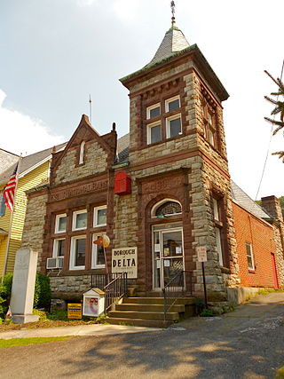
Delta is a borough in York County, Pennsylvania, United States, and one of the southernmost communities in Pennsylvania. The population was 706 at the 2020 census. It is served by the South Eastern School District which provides a public education.
Centerville is an unincorporated community in New Castle County, Delaware, United States. Centerville is now known primarily for being the location of Du Pont family estates, as well as several other wealthy business families from nearby Wilmington, and the home of Governor Jack Markell.

Orange Bend is an unincorporated community in Lake County, Florida, United States. The community is located on County Road 44 and is part of the Orlando–Kissimmee Metropolitan Statistical Area.

The Mark Trail Wilderness was designated in 1991 and currently consists of 16,400 acres (66 km2). It is named in honor of Mark Trail, a daily newspaper comic strip created by the American cartoonist Ed Dodd. The Wilderness is located within the borders of the Chattahoochee National Forest in White, Towns, and Union counties, Georgia. The Wilderness is managed by the United States Forest Service and is part of the National Wilderness Preservation System.
Penn State Brandywine is a commonwealth campus of the Pennsylvania State University located in Middletown Township, Pennsylvania. The campus was formerly known as Penn State Delaware County. The campus has baccalaureate and associate degrees and certificate programs. The campus is located on over 112 acres (450,000 m2) of grounds. In August 2017, the campus established on-campus housing for the first time with the opening of Orchard Hall, a 250-bed dormitory.
Cliftondale Park is an unincorporated community and census-designated place in Alleghany County, Virginia, United States. It was first listed as a CDP in the 2020 census with a population of 266.
Crum Lynne is an unincorporated community in Ridley Township, Delaware County, Pennsylvania, United States.

Carbon Power Plant, also known as Castle Gate Power Plant was a small, 190-MWe coal-fired power station in Utah, USA operated by PacifiCorp. Its units 1 and 2, rated at 75 and 113.6 MWe, were launched into service in 1954 and 1957. The plant is located at 39°43′38″N110°51′51″W, about 3 km (2 mi) north of Helper, Utah, on the east bank of Price River.
Holmes is an unincorporated community in Ridley Township, Delaware County, Pennsylvania, United States. It is located at 39°54′15″N75°18′31″W.
Clements is an unincorporated community in St. Mary's County, Maryland, United States. Clements is located in northern St. Mary's County. ZIP Code 20624—Area Code 301—Time Zone Eastern—Population 1,282.
Oakley Landing is an unincorporated community in Richmond County, in the U.S. state of Virginia. It is located eight miles south of Farnham at the southern tip of Hales Point, close to Tarpley Point, on the Rappahannock river.

Strong is a census-designated place in southeastern Northumberland County, Pennsylvania, United States. It is located in Mt. Carmel Township at the junction of Routes 54 and 61. The North Branch Shamokin Creek flows southwestward through Strong into the Shamokin Creek, a tributary of the Susquehanna River. It is served by the Mount Carmel post office, which uses the zip code of 17851. As of the 2010 census, the population was 147 residents.
Milburn is an unincorporated community in Carlisle County, Kentucky, United States. Its elevation is 482 feet (147 m), and it is located at 36°47′55″N88°53′59″W. Located along Kentucky Route 80 at its junction with Kentucky Routes 1371 and 1377, Milburn lies amid rolling countryside at the headwaters of Guess Creek, a tributary of Bayou du Chien; the nearest point on the Mississippi River is approximately 12 miles (19 km) to the west. Nearby cities include Arlington, 6 miles (9.7 km) by air to the west, and Bardwell, 8 miles (13 km) by air to the northwest; Milburn is connected to them by Kentucky Route 80 and Kentucky Route 1377 respectively. A state hunting preserve, the Obion Creek Wildlife Management Area, lies 2 miles (3.2 km) to the south. A fire station is located in Milburn, and a Creole cottage in the community, the George W. Stone House, is listed on the National Register of Historic Places.
Thales is an unincorporated community in Harbison Township, Dubois County, in the U.S. state of Indiana.
Faggs Manor is an unincorporated community in Londonderry Township, Chester County, Pennsylvania, United States. The hamlet, at the corner of Street Road and Faggs Manor Road includes a church and cemetery with a few nearby houses.

Thornton is an unincorporated community spanning Thornbury Township, Concord Township and Middletown Township in Delaware County, Pennsylvania, United States.
Lookout is an unincorporated area in Wayne County, Pennsylvania, United States.
Steelville is an unincorporated community in Chester County, Pennsylvania, United States. According to the 2016 census, the town has not been included in past census counts because the town is so small. It lies next to the Octoraro Creek: the border line between Lancaster County and Chester County.
References
- ↑ U.S. Geological Survey Geographic Names Information System: Kaolin, Pennsylvania
- ↑ Kennett Square, PA, 7.5 Minute Topographic Quadrangle, USGS, 1954 (1987 rev.)
- ↑ Gannett, Henry (1905). The Origin of Certain Place Names in the United States. Govt. Print. Off. pp. 172.

39°47′55″N75°43′38″W / 39.79861°N 75.72722°W
| | This Chester County, Pennsylvania state location article is a stub. You can help Wikipedia by expanding it. |