East Nantmeal Township, Chester County, Pennsylvania

Last updated
East Nantmeal Township
Warwick Farmhouse.JPG
Warwick Farmhouse, part of a historic district in the township of Warwick, neighboring East Nantmeal
Chester County Pennsylvania incorporated and unincorporated areas East Nantmeal highlighted.svg
Location in Chester County and the state of Pennsylvania.
Pennsylvania in United States (US48).svg
Location of Pennsylvania in the United States
Coordinates: 40°07′00″N75°43′59″W / 40.11667°N 75.73306°W / 40.11667; -75.73306
CountryUnited States
StatePennsylvania
County Chester
Area
[1]
  Total16.38 sq mi (42.43 km2)
  Land16.21 sq mi (41.99 km2)
  Water0.17 sq mi (0.44 km2)
Elevation
617 ft (188 m)
Population
 (2010)
  Total1,803
  Estimate 
(2016) [2]
1,841
  Density113.56/sq mi (43.85/km2)
Time zone UTC-5 (EST)
  Summer (DST) UTC-4 (EDT)
Area code 610
FIPS code 42-029-21576

East Nantmeal Township is a township in Chester County, Pennsylvania, United States. The population was 1,803 at the 2010 census. It, along with West Nantmeal Township, was originally part of a single Nantmeal Township, which was divided in 1739.

Contents

Geography

According to the U.S. Census Bureau, the township has a total area of 16.4 square miles (42 km2), of which 0.06% is water. The township is partially located in the Hopewell Big Woods.

Adjacent townships

Demographics

Historical population
CensusPop.Note
1930 594
1940 549−7.6%
1950 66521.1%
1960 7309.8%
1970 85817.5%
1980 1,22242.4%
1990 1,44818.5%
2000 1,78723.4%
2010 1,8030.9%
2020 1,8321.6%
[3]

At the 2010 census, the township was 96.0% non-Hispanic White, 0.8% Black or African American, 0.1% Native American, 0.7% Asian, and 0.7% were two or more races. 1.9% of the population were of Hispanic or Latino ancestry. [4]

As of the census [5] of 2000, there were 1,787 people, 569 households, and 451 families residing in the township. The population density was 109.1 inhabitants per square mile (42.1/km2). There were 587 housing units at an average density of 35.8 per square mile (13.8/km2). The racial makeup of the township was 97.87% White, 1.01% African American, 0.28% Asian, 0.06% Pacific Islander, 0.34% from other races, and 0.45% from two or more races. Hispanic or Latino of any race were 0.73% of the population.

There were 569 households, out of which 36.6% had children under the age of 18 living with them, 72.8% were married couples living together, 4.6% had a female householder with no husband present, and 20.7% were non-families. 16.0% of all households were made up of individuals, and 5.6% had someone living alone who was 65 years of age or older. The average household size was 2.74 and the average family size was 3.10.

In the township, the population was spread out, with 27.7% under the age of 18, 8.5% from 18 to 24, 30.1% from 25 to 44, 25.5% from 45 to 64, and 8.3% who were 65 years of age or older. The median age was 38 years. For every 100 females there were 102.8 males. For every 100 females aged 18 and over, there were 99.1 males.

The median income for a household in the township was $72,375, and the median income for a family was $78,848. Males had a median income of $52,391 versus $30,125 for females. The per capita income for the township was $32,258. About 1.8% of families and 7.4% of the population were below the poverty line, including 0.5% of those under age 18 and 4.1% of those age 65 or over.

Education

The township is within the Owen J. Roberts School District. [6] Owen J. Roberts High School is the zoned comprehensive high school.

Points of interest

Nantmeal was named by Welsh immigrants from the village of Nantmel in Radnorshire, now part of Powys. The Welsh name, Nantmel, means 'the valley of Mael', a tenth-century prince. The incorrect belief that it means 'Honey Brook' is based on a confusion between the personal name 'Mael', and the Welsh word 'mêl', 'honey'. The Thomas Bull House was built sometime between 1783 and 1796; Bull was a stonemason and the manager of Samuel Van Leer's Reading Furnace; he served as a lieutenant colonel in the Revolutionary War.

Reading Furnace straddles French Creek, which forms part of the boundary between East Nantmeal and Warwick townships. The site began as an iron furnace in 1736 and later owned by the Van Leer family. It was developed as a farm in the early 19th century, and was then remodeled as a country estate for Arthur Pew in 1936. The remodeled mansion (1812) was designed by architect R. Brognard Okie.

Reading Furnace forms a significant part of the history of the early iron industry and of the families Nutt, Rutter, Savage, Branson, Van Leer and Potts.

Welkinweir (the Grace and Everett Rodebaugh Estate) is a 162-acre (0.66 km2) preserve encompassing three buildings, gardens, ponds, natural wildlife habitat, trails, wetlands and woods. Grace and Everett Rodebaugh purchased the aging farm in 1935 as a weekend retreat and summer home. They retained architect Fridtjof Tobiessen to "make the mansion livable." This may be the only significant residential commission of Tobiessen, whose principal works were public schools, memorials, and churches.

Brower's Bridge, Nantmeal Village Historic District, Thomas Bull House, Warwick Furnace Farms, and Welkinweir are listed on the National Register of Historic Places. [7]

Transportation

The Pennsylvania Turnpike/I-76 eastbound in East Nantmeal Township 2022-08-31 12 44 59 View east along Interstate 76 (Pennsylvania Turnpike Philadelphia Extension) from the overpass for Adams Drive in East Nantmeal Township, Chester County, Pennsylvania.jpg
The Pennsylvania Turnpike/I-76 eastbound in East Nantmeal Township

As of 2018, there were 43.97 miles (70.76 km) of public roads in East Nantmeal Township, of which 1.60 miles (2.57 km) were maintained by the Pennsylvania Turnpike Commission (PTC), 14.42 miles (23.21 km) were maintained by the Pennsylvania Department of Transportation (PennDOT) and 28.95 miles (46.59 km) were maintained by the township. [8]

The Pennsylvania Turnpike (I-76) runs through southwestern portions of the township, but there are no interchanges within the township. The nearest interchange is with Pennsylvania Route 100, which follows Pottstown Pike along a northeast-southwest alignment through the eastern portion of the township. Pennsylvania Route 345 follows Bulltown Road along a northeast-southwest alignment through the western portion of the township. Finally, Pennsylvania Route 401 follows Conestoga Road along a northwest-southeast alignment through the central portion of the township.

Notable person

Related Research Articles

<span class="mw-page-title-main">Caernarvon Township, Berks County, Pennsylvania</span> Township in Pennsylvania, United States

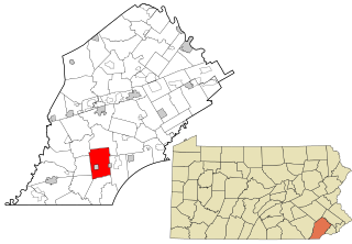
Caernarvon Township is a township in Berks County, Pennsylvania, United States. The population was 4,252 at the 2020 census. It is often referred to as Morgantown, the township's largest village.

<span class="mw-page-title-main">Robeson Township, Berks County, Pennsylvania</span> Township in Pennsylvania, United States

Robeson Township is a township in Berks County, Pennsylvania, United States. The population was 7,216 at the 2010 census.

<span class="mw-page-title-main">Charlestown Township, Chester County, Pennsylvania</span> Township in Pennsylvania, United States

Charlestown Township is a township in Chester County, Pennsylvania, United States. The population was 6,003 at the 2020 census.

<span class="mw-page-title-main">East Bradford Township, Chester County, Pennsylvania</span> Township in Pennsylvania, United States

East Bradford Township is a township in Chester County, Pennsylvania, United States. The population was 10,308 at the 2020 census.

<span class="mw-page-title-main">East Caln Township, Chester County, Pennsylvania</span> Township in Pennsylvania, United States

East Caln Township is a township in Chester County, Pennsylvania, United States. The population was 5,380 at the 2020 census. The township wraps around the eastern half of Downingtown and is mostly indistinguishable from it. East Caln Township is very developed, containing several shopping centers, including the regionally important Brandywine Square Center, several recently constructed housing developments varying from condominiums to large single family homes, and some industry in the southern fringe of the township.

<span class="mw-page-title-main">East Coventry Township, Chester County, Pennsylvania</span> Township in Pennsylvania, United States

East Coventry Township is a township in Chester County, Pennsylvania, United States. The population was 7,068 at the 2020 census.

<span class="mw-page-title-main">East Nottingham Township, Chester County, Pennsylvania</span> Township in Pennsylvania, United States

East Nottingham Township is a township in Chester County, Pennsylvania, United States. The population was 8,650 at the 2020 census.

<span class="mw-page-title-main">Elverson, Pennsylvania</span> Borough in Pennsylvania, United States

Elverson is a borough in Chester County, Pennsylvania, United States. The population was 1,332 at the 2020 census.

<span class="mw-page-title-main">Honey Brook, Pennsylvania</span> Borough in Pennsylvania, United States

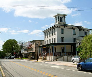
Honey Brook is a borough in Chester County, Pennsylvania, United States. The population of the borough was 1,895 at the 2020 census. The borough is surrounded by Honey Brook Township, and both are referred to locally collectively as Honey Brook.

<span class="mw-page-title-main">London Grove Township, Chester County, Pennsylvania</span> Township in Pennsylvania, United States

London Grove Township is a township in Chester County, Pennsylvania, United States. The population was 8,797 at the 2020 census.

<span class="mw-page-title-main">North Coventry Township, Pennsylvania</span> Township in Pennsylvania, United States

North Coventry Township is a township in Chester County, Pennsylvania, United States. The population was 7,866 at the 2010 census.

<span class="mw-page-title-main">Pennsbury Township, Pennsylvania</span> Township in Pennsylvania, United States

Pennsbury Township is a township in Chester County, Pennsylvania, United States. The population was 3,604 at the 2010 census.

<span class="mw-page-title-main">Sadsbury Township, Chester County, Pennsylvania</span> Township in Pennsylvania, United States

Sadsbury Township is a township in Chester County, Pennsylvania, United States. The population was 3,570 at the 2010 census.

<span class="mw-page-title-main">South Coventry Township, Pennsylvania</span> Township in Pennsylvania, United States

South Coventry Township is a township in Chester County, Pennsylvania, United States. The population was 2,604 at the 2010 census.

<span class="mw-page-title-main">Upper Uwchlan Township, Pennsylvania</span> Township in Pennsylvania, United States

Upper Uwchlan Township is a township in Chester County, Pennsylvania, United States. The population was 11,227 at the 2010 census. The township included the community of Milford Mills before it was inundated by the creation of the Marsh Creek Dam in 1972.

<span class="mw-page-title-main">Valley Township, Chester County, Pennsylvania</span> Township in Pennsylvania, United States

Valley Township is a township in Chester County, Pennsylvania, United States. The population was 6,794 at the 2010 census.

<span class="mw-page-title-main">Warwick Township, Chester County, Pennsylvania</span> Township in Pennsylvania, United States

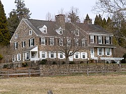
Warwick Township is a township in Chester County, Pennsylvania, United States. The population was 2,507 at the 2010 census.

<span class="mw-page-title-main">West Nantmeal Township, Pennsylvania</span> Township in Pennsylvania, United States

West Nantmeal Township is a township in Chester County, Pennsylvania, United States. The population was 2,170 at the 2010 census. It and East Nantmeal Township were originally part of a single Nantmeal Township, which was divided in 1739.

<span class="mw-page-title-main">West Sadsbury Township, Pennsylvania</span> Township in Pennsylvania, United States

West Sadsbury Township is a township in Chester County, Pennsylvania, United States. The population was 2,444 at the 2010 census.

<span class="mw-page-title-main">Westtown Township, Pennsylvania</span> Township in Pennsylvania, United States

Westtown Township is a township in Chester County, Pennsylvania, United States. The population was 10,827 at the 2010 census.

References

  1. "2016 U.S. Gazetteer Files". United States Census Bureau. Retrieved Aug 13, 2017.
  2. "Population and Housing Unit Estimates" . Retrieved June 9, 2017.
  3. "Census 2020".
  4. "Census 2010: Philadelphia gains, Pittsburgh shrinks in population". USA Today . Archived from the original on 2011-03-14.
  5. "U.S. Census website". United States Census Bureau . Retrieved 2008-01-31.
  6. "2020 CENSUS - SCHOOL DISTRICT REFERENCE MAP: Chester County, PA" (PDF). U.S. Census Bureau . Retrieved 2022-10-19.
  7. "National Register Information System". National Register of Historic Places . National Park Service. July 9, 2010. Retrieved 2023-06-14.
  8. "East Nantmeal Township map" (PDF). PennDOT. Retrieved March 13, 2023.