Christina River

Last updated • 3 min readFrom Wikipedia, The Free Encyclopedia

Christina River
Tributary to Delaware River
Christina River Wilmington.jpg
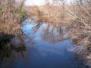
The Christina River in Wilmington in 2006
Christina brandywine.png
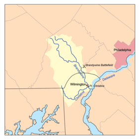
Christina River/Brandywine Creek watershed
Location
CountryUnited States
State Pennsylvania, Maryland, Delaware
County New Castle (DE)
Chester (PA)
Cities Newark, DE, Newport, DE, Wilmington, DE
Physical characteristics
Source 
  location Franklin Township, Chester County, Pennsylvania
  coordinates 39°44′47″N75°48′53″W / 39.74639°N 75.81472°W / 39.74639; -75.81472 [1]
  elevation380 ft (120 m) [2]
Mouth Delaware River
  location
Wilmington, New Castle County, Delaware
  coordinates
39°42′57″N75°30′44″W / 39.71583°N 75.51222°W / 39.71583; -75.51222 [1]
  elevation
0 ft (0 m) [1]
Length35 mi (56 km) approximately [3]
Basin size565 sq mi (1,460 km2) [4]
Basin features
Progression Delaware RiverDelaware BayAtlantic Ocean
Tributaries 
  left East Branch Christina River, White Clay Creek, Little Mill Creek, Brandywine Creek
  rightWest Branch Christina River

The Christina River is a tributary of the Delaware River, approximately 35 miles (56 km) long, in northern Delaware. It also flows through small areas of southeastern Pennsylvania and northeastern Maryland. Near its mouth, the river flows past downtown Wilmington, Delaware, forming the city's harbor for traffic on the Delaware River. The Port of Wilmington, opened in 1923 at the river's mouth, handles international cargo and trade. [5]

Contents

The river rises in southeastern Pennsylvania in Franklin Township in southern Chester County, and initially flows southeastwardly, passing through the northeastern extremity of Maryland in northeastern Cecil County, into New Castle County in Delaware, where it flows through western and southern areas of the city of Newark and then turns northeastwardly, passing the town of Newport and approaching Wilmington from the southwest. It receives White Clay Creek from the west near Newport, and Brandywine Creek in Wilmington, approximately 2 miles (3 km) upstream of its mouth. [6] [7]

The Christina River in its upper course in 2006, near the community of Christiana Christina River.jpg
The Christina River in its upper course in 2006, near the community of Christiana

The Christina River and its tributaries drain an area of 565 square miles, 1,460 km2. Brandywine Creek, despite being a tributary of the Christina, drains 58% of this area (325 square miles, 840 km2). White Clay Creek and its tributary, Red Clay Creek, drain a further 28% of the basin (161 square miles, 420 km2). Including Brandywine Creek, 71% of the Christina's basin is in Pennsylvania (400 square miles, 1,000 km2); 28% is in Delaware (157 square miles, 410 km2); and 1% is in Maryland (8 square miles, 21 km2). The basin's streams supply approximately 100 million gallons (400 million liters) of water per day for more than half a million people in the three states, providing 75% of the water supply for New Castle County, Delaware, and more than 40% of the water supply for Chester County, Pennsylvania. [4]

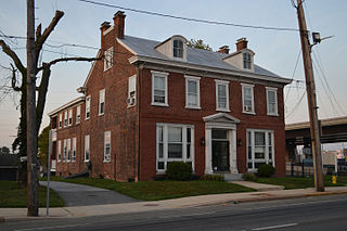
The river was named for Queen Christina of Sweden. Fort Christina, the first permanent European settlement in Delaware, was established at the confluence of Brandywine Creek and the Christina River in 1638 as a part of the Swedish colony of New Sweden. The fort was captured by the Dutch in 1655, and by the English in 1664. [8]

Many rowing teams and clubs in Wilmington practice along the Christina River, among them the Wilmington Youth Rowing Association, Wilmington rowing association, Newport Rowing Club, and University of Delaware. In addition, there is a fall "head race" occurring on the river by the name of the Head of the Christina held every year in the boat house of Wilmington youth rowing association.[ citation needed ]

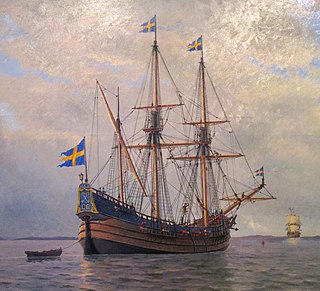
Just south of downtown Wilmington, the Christina provides home port to the "Kalmar Nyckel", Delaware's official Tall Ship. Co-located with the Kalmar Nyckel is the home port to the U.S. Coast Guard Auxiliary's Search and Rescue Detachment (SARDET) Wilmington.[ citation needed ]

The Christina River is also one of many Striped Bass spawning areas that empty into the Delaware River.[ citation needed ]

The Christina Riverwalk makes up a segment of the East Coast Greenway, a 3,000 mile long system of trails connecting Maine to Florida.[ citation needed ]

Variant names and spellings

According to the Geographic Names Information System, the Christina River has also been known historically as: [1]

  • Christeen Creek
  • Christeen River
  • Christen River
  • Christian Creek
  • Christiana Creek
  • Christiana River
  • Christianna Creek
  • Christians Creek
  • Christiany River
  • Christien Creek
  • Christien River
  • Christina Creek
  • Christine Creek
  • Christine River
  • Elbe River
  • Manques Kill
  • Minquaas Kill
  • Minquas Kill
  • Minquas River
  • Minques Kill
  • Minquess Kill
  • Sickpeckons
  • Sippunk
  • Supeckonagh
  • Tasswaijres

See also

Related Research Articles

<span class="mw-page-title-main">New Sweden</span> Swedish colony in North America (1638–1655)

New Sweden was a colony of the Swedish Empire between 1638 and 1655 along the lower reaches of the Delaware River in what is now Delaware, Maryland, New Jersey, and Pennsylvania. Established during the Thirty Years' War when Sweden was a great power, New Sweden formed part of the Swedish efforts to colonize the Americas.

<span class="mw-page-title-main">New Castle County, Delaware</span> County in Delaware, United States

New Castle County is the northernmost of the three counties of the U.S. state of Delaware. As of the 2020 census, the population was 570,719, making it the most populous county in Delaware, with nearly 60% of the state's population of 989,948. The county seat is Wilmington, which is also the state's most populous city. New Castle County is included in the Philadelphia-Camden-Wilmington, PA-NJ-DE-MD Metropolitan Statistical Area. The county is named after William Cavendish, 1st Duke of Newcastle. New Castle County has the highest population and population density of any Delaware county, and it is the smallest county in the state by area. It has more people than the other two counties, Kent and Sussex, combined. It is also the most economically developed of the three.

<span class="mw-page-title-main">Newport, Delaware</span> Town in Delaware, United States

Newport is a town in New Castle County, Delaware, United States. It is on the Christina River. It is best known for being the home of colonial inventor Oliver Evans. The population was 1,055 at the 2010 census. Four limited access highways, I-95, I-295, I-495, and Delaware Route 141 intersect within one mile (1.6 km) of the town.

<span class="mw-page-title-main">Wilmington, Delaware</span> Largest city in Delaware, United States

Wilmington is the most populous city in the U.S. state of Delaware. The city was built on the site of Fort Christina, the first Swedish settlement in North America. It lies at the confluence of the Christina River and Brandywine Creek, near where the Christina flows into the Delaware River. It is the county seat of New Castle County and one of the major cities in the Delaware Valley metropolitan area. Wilmington was named by Proprietor Thomas Penn after his friend Spencer Compton, Earl of Wilmington, who was prime minister during the reign of George II of Great Britain.

<span class="mw-page-title-main">Mispillion River</span> River in United States of America

The Mispillion River is a river flowing to Delaware Bay in southern Delaware in the United States. It is approximately 15 miles (24 km) long and drains an area of 76 square miles (200 km2) on the Atlantic Coastal Plain.

<span class="mw-page-title-main">Brandywine Creek (Christina River tributary)</span> Creek in Pennsylvania and Delaware, US

Brandywine Creek is a tributary of the Christina River in southeastern Pennsylvania and northern Delaware in the United States. The Lower Brandywine is 20.4 miles (32.8 km) long and is a designated Pennsylvania Scenic River with several tributary streams. The East Branch and West Branch of the creek originate within 2 miles (3 km) of each other on the slopes of Welsh Mountain in Honey Brook Township, Pennsylvania, about 20 miles (32 km) northwest of their confluence.

<span class="mw-page-title-main">White Clay Creek</span> River in Delaware, United States

White Clay Creek is an 18.5-mile-long (29.8 km) tributary of the Christina River in southern Pennsylvania and northern Delaware in the United States. It is renowned for its scenic character and is largely federally protected.

<span class="mw-page-title-main">Appoquinimink River</span> River in Delaware, United States

The Appoquinimink River is a river flowing to Delaware Bay in northern Delaware in the United States. The river is 15.3 miles (24.6 km) long and drains an area of 47 square miles (120 km2) on the Atlantic Coastal Plain.

<span class="mw-page-title-main">St. Jones River</span> River in Delaware, United States

The St. Jones River is a river flowing to Delaware Bay in central Delaware in the United States. It is 12.8 miles (20.6 km) long and drains an area of 36 square miles (93 km2) on the Atlantic Coastal Plain.

<span class="mw-page-title-main">Broadkill River</span> River in Delaware, United States

The Broadkill River is a river flowing to Delaware Bay in southern Delaware in the United States. It is 13.3 miles (21.4 km) long and drains an area of 110 square miles (280 km2) on the Atlantic Coastal Plain.

Red Clay Creek is a 12.7-mile-long (20.4 km) tributary of White Clay Creek, running through southeastern Pennsylvania and northern Delaware in the United States. As of 2000, portions of the creek are under wildlife habitat protection.

<i>Kalmar Nyckel</i> Swedish ship built by the Dutch

Kalmar Nyckel was a Swedish ship built by the Dutch famed for carrying Swedish settlers to North America in 1638, to establish the colony of New Sweden. The name Kalmar Nyckel comes from the Swedish city of Kalmar and nyckel meaning 'key' in Swedish. The name was also a tribute to Kalmar Castle which was a symbol of power during the time of the Swedish Empire when Sweden was a military great power. A replica of the ship was launched at Wilmington, Delaware, in 1997.

Christiana Hundred is an unincorporated subdivision of New Castle County, Delaware. Hundreds were once used as a basis for representation in the Delaware General Assembly, and while their names still appear on all real estate transactions, they presently have no meaningful use or purpose except as a geographical point of reference.

<span class="mw-page-title-main">Wolf River (Kansas)</span> River in Kansas, United States

The Wolf River is a 45.7-mile-long (73.5 km) tributary of the Missouri River in northeastern Kansas in the United States, draining an area of 247.8 square miles (642 km2) in the Dissected Till Plains region.

<span class="mw-page-title-main">Hackers Creek</span> River in the United States of America

Hackers Creek is a tributary of the West Fork River, 25.4 miles (40.9 km) long, in north-central West Virginia in the United States. Via the West Fork, Monongahela and Ohio Rivers, it is part of the watershed of the Mississippi River, draining an area of 58 square miles (150 km2) on the unglaciated portion of the Allegheny Plateau. The stream is believed to have been named for a settler named John Hacker (1743-1824), who lived near the creek for over twenty years from around 1770. He was a magistrate and patriarch in the settlement despite not being able to write.

<span class="mw-page-title-main">Tenmile Creek (West Fork River tributary)</span> Tributary of river in West Virginia

Tenmile Creek is a tributary of the West Fork River, 26.4 miles (42.5 km) long, in north-central West Virginia in the United States. Via the West Fork, Monongahela and Ohio Rivers, it is part of the watershed of the Mississippi River, draining an area of 126 square miles (330 km2) on the unglaciated portion of the Allegheny Plateau.

<span class="mw-page-title-main">Wheeling Creek (West Virginia)</span> River in West Virginia, United States

Wheeling Creek is a tributary of the Ohio River, 25 miles (40 km) long, in the northern panhandle of West Virginia, with a watershed extending into southwestern Pennsylvania. Via the Ohio River, it is part of the watershed of the Mississippi River, draining an area of approximately 300 square miles (780 km2) on the unglaciated portion of the Allegheny Plateau. It flows into the Ohio River in downtown Wheeling, just downstream of Ohio's Wheeling Creek on the opposite bank. A variant name is Big Wheeling Creek. According to the French explorer Pierre Joseph Céloron de Blainville, the native name of the stream is the Kanououara River, as was inscribed on the lead plate buried at the mouth by the Ohio River in 1749.

<span class="mw-page-title-main">Shellpot Creek</span> River in Delaware, United States

Shellpot Creek is a tributary of the Delaware River in northeast New Castle County, Delaware. The stream rises between Grubb Road and Shipley Road, south of Naaman's Road at 39°49′19″N75°31′55″W in Brandywine Hundred and flows southeast for about six miles before discharging into the Delaware River at 39°44′05″N75°30′16″W near Edgemoor. Prior to 1938, the stream drained into the Brandywine Creek, but was subsequently redirected to the Delaware River.

<span class="mw-page-title-main">Little Mill Creek (Christina River tributary)</span> River in Delaware, United States

Little Mill Creek is a 3.29 mi (5.29 km) long 3rd order tributary to Christina River in New Castle County, Delaware.

References

  1. 1 2 3 4 Geographic Names Information System. "GNIS entry for Christina River (Feature ID #213799)" . Retrieved 2007-02-18.
  2. Google Earth. Elevation data for source coordinates.
  3. "Columbia Gazetteer of North America entry for Christina River". 2000. Archived from the original on 2005-04-22. Retrieved 2007-02-18.
  4. 1 2 University of Delaware: Institute for Public Administration, Water Resources Agency (1999-01-15). "Christina River Basin". Archived from the original on 2007-02-07. Retrieved 2007-02-18.
  5. "Port of Wilmington website". 2006. Archived from the original on 2007-02-17. Retrieved 2007-02-18.
  6. DeLorme (2004). Maryland Delaware Atlas & Gazetteer. Yarmouth, Maine: DeLorme. ISBN   0-89933-279-X.
  7. DeLorme (2003). Pennsylvania Atlas & Gazetteer. Yarmouth, Maine: DeLorme. ISBN   0-89933-280-3.
  8. The Historical Society of Delaware. "Early Settlement". Archived from the original on 2007-03-02. Retrieved 2007-02-18.