
The Potomac River is a major river in the Mid-Atlantic region of the United States that flows from the Potomac Highlands in West Virginia to the Chesapeake Bay in Maryland. It is 405 miles (652 km) long, with a drainage area of 14,700 square miles (38,000 km2), and is the fourth-largest river along the East Coast of the United States. More than 6 million people live within its watershed.

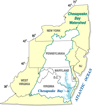
The Chesapeake Bay is the largest estuary in the United States. The bay is located in the Mid-Atlantic region and is primarily separated from the Atlantic Ocean by the Delmarva Peninsula, including parts of the Eastern Shore of Maryland, the Eastern Shore of Virginia, and the state of Delaware. The mouth of the bay at its southern point is located between Cape Henry and Cape Charles. With its northern portion in Maryland and the southern part in Virginia, the Chesapeake Bay is a very important feature for the ecology and economy of those two states, as well as others surrounding within its watershed. More than 150 major rivers and streams flow into the bay's 64,299-square-mile (166,534 km2) drainage basin, which covers parts of six states and all of Washington, D.C.

The Delmarva Peninsula, or simply Delmarva, is a large peninsula on the East Coast of the United States, occupied by the vast majority of the state of Delaware and parts of the Eastern Shore of Maryland and Eastern Shore of Virginia.

Saxis is a town in Accomack County, Virginia, United States. The population was 241 at the 2010 census.

The Pocomoke River stretches approximately 66 miles (106 km) from southern Delaware through southeastern Maryland in the United States. At its mouth, the river is essentially an arm of Chesapeake Bay, whereas the upper river flows through a series of relatively inaccessible wetlands called the Great Cypress Swamp, largely populated by Loblolly Pine, Red Maple and Bald Cypress. The river is the easternmost river that flows into Chesapeake Bay. "Pocomoke", though traditionally interpreted as "dark water" by local residents, is now agreed by scholars of the Algonquian languages to be derived from the words for "broken ground."

U.S. Route 13 or U.S. Highway 13 (US 13) is a north–south United States Numbered Highway established in 1926 that runs for 518 miles (834 km) from Interstate 95 (I-95) just north of Fayetteville, North Carolina, to US 1 in the northeastern suburbs of Philadelphia, Pennsylvania, near Morrisville. In all, it traverses five states in the Atlantic coastal plain region. It follows the Atlantic coast more closely than does the main north–south U.S. Highway of the region, US 1. Because of this, its number is out of place on the general U.S. Highway numbering grid, as it should be running west of US 11 but does not. Its routing is largely rural, the notable exceptions being the Hampton Roads area in Virginia and the northern end of the highway in Delaware and Pennsylvania. It is also notable for being the main thoroughfare for the Delmarva Peninsula and carrying the Chesapeake Bay Bridge–Tunnel to it in Virginia.

The Eastern Shore of Maryland is a part of the U.S. state of Maryland that lies mostly on the east side of the Chesapeake Bay. Nine counties are normally included in the region. The Eastern Shore is part of the larger Delmarva Peninsula that Maryland shares with Delaware and Virginia.

Cherry Run is a 7.2-mile-long (11.6 km) meandering stream that forms the northern section of the boundary between Morgan and Berkeley counties in West Virginia's Eastern Panhandle. While it is mostly non-navigable, Cherry Run provides many pools of varying depths for fishing and swimming. As a tributary of the Potomac River, Cherry Run is part of the Potomac and Chesapeake Bay watersheds.

The skipjack is a traditional fishing boat used on the Chesapeake Bay for oyster dredging. It is a sailboat which succeeded the bugeye as the chief oystering boat on the bay, and it remains in service due to laws restricting the use of powerboats in the Maryland state oyster fishery.
The Chesapeake Bay Program is the regional partnership that directs and conducts the restoration of the Chesapeake Bay in the United States. As a partnership, the Chesapeake Bay Program brings together members of various state, federal, academic and local watershed organizations to build and adopt policies that support Chesapeake Bay restoration. By combining the resources and unique strengths of each individual organization, the Chesapeake Bay Program is able to follow a unified plan for restoration. The program office is located in Annapolis, Maryland.

The Mount Vernon Conference was a meeting of delegates from Virginia and Maryland held at Mount Vernon on March 21–28, 1785, to discuss navigational rights in the states' common waterways. On March 28, 1785, the group drew up a thirteen-point proposal to govern the rights of both states on the Potomac River, Pocomoke River, and Chesapeake Bay. Known as the Mount Vernon Compact and formally titled as the Compact of 1785, this agreement not only covered tidewater navigation but also extended to issues such as toll duties, commerce regulations, fishing rights, and debt collection. Ratified by the legislature of both states, the compact helped set a precedent for later meetings between states for discussions into areas of mutual concern.
The Virginia Marine Police is the law enforcement division of the Virginia Marine Resources Commission, an agency of the Commonwealth of Virginia, United States.
Pocomoke State Forest is a state forest of Maryland that lies on both banks of the Pocomoke River in Worcester County. The portion north of the Pocomoke lies between Dividing and Nassawango Creeks. The Pocomoke River Wildlife Management Area borders the southern portion of the forest.
Saxis Wildlife Management Area is a 5,578-acre (22.57 km2) Wildlife Management Area (WMA) in Accomack County, Virginia. Predominantly tidal marshland, it is divided into three tracts, all located on peninsulas bordering on brackish waters such as Beasley Bay, Pocomoke Sound, and Messongo Creek. Several smaller freshwater creeks are also found on the property. Portions of the area farthest inland are occupied by hummocks. The property is maintained by the Virginia Department of Game and Inland Fisheries mostly in its natural state, with little in the way of human management or development.
Tangier Sound is a sound of the Chesapeake Bay bounded on the west by Tangier Island in Virginia, and Smith Island and South Marsh Island in Maryland, by Deal Island in Maryland on the north, and the mainland of the Eastern Shore of Maryland and Pocomoke Sound on the east. It stretches into Virginia as far south as Watts Island.

Glenn Martin National Wildlife Refuge includes the northern half of Smith Island, which lies 11 miles (18 km) west of Crisfield, Maryland, and Watts Island, which is located between the eastern shore of Virginia and Tangier Island. Both islands are situated in the lower Chesapeake Bay.
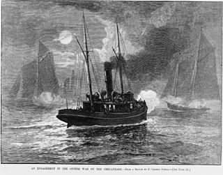
The Oyster Wars were a series of sometimes violent disputes between oyster pirates and authorities and legal watermen from Maryland and Virginia in the waters of the Chesapeake Bay and the Potomac River from 1865 until about 1959.
Wharton v. Wise, 153 U.S. 155 (1894), is a 9-to-0 ruling by the Supreme Court of the United States, which denied a citizen of the state of Maryland a writ of habeas corpus. The appellant, tried and convicted of illegally harvesting oysters from Pocomoke Sound in the Chesapeake Bay, had argued that his right to fish was protected by an interstate compact and that this compact also barred the state of Virginia from trying him. The Supreme Court disagreed on both counts.

