Related Research Articles
Harmony is an unincorporated community in Caroline County, Maryland, United States. It is little more than an intersection of state Routes 16 and 578 on Maryland's Eastern Shore. Its original name was Fowling Creek, named after a stream nearby that is a tributary of the Choptank River.
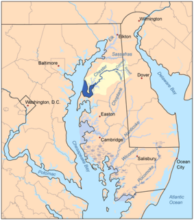
The Chester River is a major tributary of the Chesapeake Bay on the Delmarva Peninsula. It is about 43 miles (69 km) long, and its watershed encompasses 368 sq mi (950 km2), which includes 295 sq mi (760 km2) of land. Thus the total watershed area is 20% water. It forms the border between Kent County and Queen Anne's County, Maryland, with its headwaters extending into New Castle County and Kent County, Delaware. Chestertown, the seat of Maryland's Kent County, is located on its north shore. It is located south of the Sassafras River and north of Eastern Bay, and is connected with Eastern Bay through Kent Narrows.

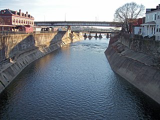
Antietam Creek is a 41.7-mile-long (67.1 km) tributary of the Potomac River located in south central Pennsylvania and western Maryland in the United States, a region known as the Hagerstown Valley. The creek became famous as a focal point of the Battle of Antietam during the American Civil War.
Wills Creek is a 38.6-mile-long (62.1 km) tributary of the North Branch Potomac River in Pennsylvania and Maryland in the United States.

Piscataway Creek is an 18.6-mile-long (29.9 km) tributary of the Potomac River in Prince George's County, Maryland. The creek is a tidal arm of the Potomac for its final 2.5 miles (4.0 km), entering the Potomac at Fort Washington Park. Tinkers Creek is a tributary to Piscataway Creek, converging from the north 4.5 miles (7.2 km) upstream of the mouth of the Piscataway. The United States Geological Survey records two variant names for Piscataway Creek: Pascattawaye Creek and Puscattuway Creeke.

Mattawoman Creek is a 30.0-mile-long (48.3 km) coastal-plain tributary to the tidal Potomac River with a mouth at Indian Head, Maryland, 20 miles (32 km) downstream of Washington, D.C. It comprises a 23-mile (37 km) river flowing through Prince George's and Charles counties and a 7-mile (11 km) tidal-freshwater estuary in Charles County. About three-fourths of its 94-square-mile (240 km2) watershed lies in Charles County, with the remainder in Prince George's County immediately to the north.

The Bohemia River is a 4.7-mile-long (7.6 km) tributary of the Elk River on the Delmarva Peninsula. It is located in Cecil County, Maryland, with its headwaters extending into New Castle County, Delaware.

Sherman Creek is a 53.4-mile-long (85.9 km) tributary of the Susquehanna River in Perry County, Pennsylvania in the United States.

The Casselman River is a 56.5-mile-long (90.9 km) tributary of the Youghiogheny River in western Maryland and Pennsylvania in the United States. The Casselman River drains an area of 576 square miles.
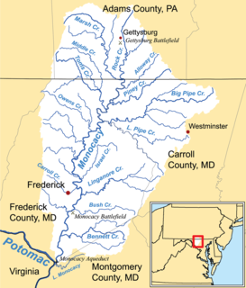
Marsh Creek is a 26.6-mile-long (42.8 km) tributary of the Monocacy River in south-central Pennsylvania and north-central Maryland in the United States.
Nanjemoy Creek is a 13.1-mile-long (21.1 km) tidal tributary of the Potomac River in Charles County, Maryland, United States, located between Cedar Point Neck and Tayloe Neck. Its watershed area is 73 square miles (190 km2), with 2% impervious surface in 1994.

Town Creek is a 41.6-mile-long (66.9 km) tributary stream of the Potomac River in the U.S. states of Maryland and Pennsylvania. The creek is formed from the confluence of Sweet Root Creek and Elk Lick Creek, about 0.5 miles (0.8 km) south of Buchanan State Forest in Bedford County, Pennsylvania. Town Creek flows south along the base of Warrior Mountain into Allegany County, Maryland. The Chesapeake and Ohio Canal crosses it at the Town Creek Aqueduct. It empties into the Potomac about 4 miles (6 km) east of Oldtown, Maryland.
Little Conococheague Creek is a 12.4-mile-long (20.0 km) tributary stream of the Potomac River in the U.S. states of Maryland and Pennsylvania. The stream rises on Two Top Mountain, west of the Whitetail Ski Resort in Franklin County, Pennsylvania, and proceeds south into Washington County, Maryland. It empties into the Potomac about 2 miles (3 km) southeast of Big Spring, Maryland. The watershed of the creek is 18 square miles (47 km2) and includes Indian Springs Wildlife Management Area. Tributaries include Toms Run.

Pohick Creek is a 14.0-mile-long (22.5 km) tributary stream of the Potomac River in Fairfax County in the U.S. state of Virginia. It takes its name from the Pohick Native American tribe once prevalent in the area.
Oxon Creek is a stream on the Potomac River which feeds a cove that straddles the border between Washington, D.C. and Prince George's County, Maryland just north of Interstate 495 at Woodrow Wilson Bridge. Oxon Creek heads at the confluence of Oxon Run and Barnaby Run, sometimes referred to as Winkle Doodle Run. It starts just inside the boundary of D.C. and then runs 1.5 miles (2.4 km) to the south and west into Maryland to empty into the Potomac at Goose Island across from the city of Alexandria, Virginia. Before reaching the Potomac, the creek widens to form Oxon Cove which is partially in Maryland and partially in Washington, D.C.. The creek is almost entirely within Oxon Cove National Park, except for the first few feet in D.C. and a portion of the cove on the southside of the Blue Plains Advanced Wastewater Treatment Plant.
Muddy Creek is a tributary of the Susquehanna River in York County, Pennsylvania, in the United States.

The Tred Avon River is a main tributary of the Choptank River in Talbot County on Maryland's Eastern Shore. The river is 17 miles (27 km) long.
The Little Choptank River is a tidal river in Dorchester County in the U.S. state of Maryland. The river rises at the confluence of Lee Creek and Gary Creek 3 miles (4.8 km) west of Cambridge.
Frog Mortar Creek is a tidal creek in Baltimore County, Maryland. The creek empties into the Middle River and surrounds the northeast and southeast sides of Martin State Airport.
Alloway Creek is a 13.5-mile-long (21.7 km) tributary of the Monocacy River in Pennsylvania and Maryland in the United States. Via the Monocacy River, it is part of the Potomac River watershed.
References
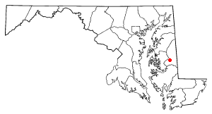
- 1 2 "Corsica River". Geographic Names Information System . United States Geological Survey . Retrieved June 8, 2011.