Related Research Articles

The Potomac River is a major river in the Mid-Atlantic region of the United States that flows from the Potomac Highlands in West Virginia to the Chesapeake Bay in Maryland. It is 405 miles (652 km) long, with a drainage area of 14,700 square miles (38,000 km2), and is the fourth-largest river along the East Coast of the United States. More than 6 million people live within its watershed.

The Anacostia River is a river in the Mid Atlantic region of the United States. It flows from Prince George's County in Maryland into Washington, D.C., where it joins with the Washington Channel and ultimately empties into the Potomac River at Buzzard Point. It is about 8.7 miles (14.0 km) long. The name "Anacostia" derives from the area's early history as Nacotchtank, a settlement of Necostan or Anacostan Native Americans on the banks of the Anacostia River.
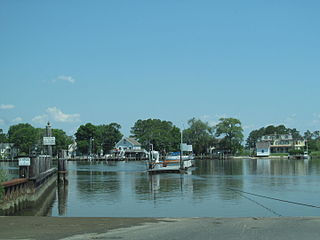
The Wicomico River is a 24.4-mile-long (39.3 km) tributary of the Chesapeake Bay on the eastern shore of Maryland. It drains an area of low marshlands and farming country in the middle Delmarva Peninsula.

U.S. Route 522 is a spur route of US 22 in the states of Virginia, West Virginia, Maryland, and Pennsylvania. The U.S. Highway travels in a north-south direction, and runs 308.59 miles (496.63 km) from US 60 near Powhatan, Virginia, to its northern terminus at US 11 and US 15 near Selinsgrove, Pennsylvania. US 522 serves many small cities and towns in the Piedmont, Blue Ridge Mountains, and northern Shenandoah Valley of Virginia. The highway serves the Virginia communities of Goochland, Mineral, Culpeper, the town of Washington, and Front Royal and the independent city of Winchester. US 522 then follows the Ridge-and-Valley Appalachians north and then east through the Eastern Panhandle of West Virginia, a 2-mile-wide (3.2 km) stretch of Western Maryland, and South Central Pennsylvania to its terminus in the Susquehanna Valley. The highway serves Berkeley Springs, West Virginia; Hancock, Maryland; and the Pennsylvania communities of McConnellsburg, Mount Union, Lewistown, and Middleburg.

Deep Creek Lake State Park is a public recreation area occupying more than 1,100 acres (450 ha) on the northeast side of Deep Creek Lake in Garrett County, Maryland, in the United States. The park features water activities, camping facilities, and recreational trails and is located about 18 miles (29 km) south of Interstate 68 on U.S. Route 219.

Seneca Creek State Park is a public recreation area encompassing more than 6,300 acres (2,500 ha) along 14 miles of Seneca Creek in its run to the Potomac River in Montgomery County, Maryland. The park features facilities for boating and fishing as well as trails for hiking, cycling, and horseback riding. It is managed by the Maryland Department of Natural Resources.
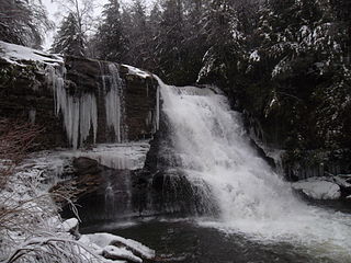
Swallow Falls State Park is a public recreation area located on the west bank of the Youghiogheny River nine miles (14 km) northwest of Oakland in Garrett County, Maryland, in the United States. The state park features Maryland's highest free-falling waterfall, the 53-foot (16 m) Muddy Creek Falls, as well as smaller waterfalls on the Youghiogheny River and Tolivar Creek. The park is notable for its stand of old hemlock trees, some more than 300 years old, "the last stand of its kind in Maryland."

White Clay Creek Preserve is a 3,050-acre (1,230 ha) Pennsylvania state park along the valley of White Clay Creek in London Britain Township in Chester County, Pennsylvania in the United States. The park was donated by the DuPont Company in 1984 for the purpose of "preserving the diverse and unique plant and animal species, and the rich cultural heritage of the area". Dupont also donated an additional 528 acres (214 ha) for the adjoining White Clay Creek State Park to the state of Delaware. White Clay Creek Preserve is 3 miles (4.8 km) north of Newark, Delaware on Pennsylvania Route 896.
Cabin John Creek is a tributary stream of the Potomac River in Montgomery County, Maryland. The watershed covers an area of 26 square miles (67 km2). The headwaters of the creek originate in the city of Rockville, and the creek flows southward for 10.9 miles (17.5 km) to the Potomac River.

Rocks State Park is a public recreation area located in and around Deer Creek Valley near Pylesville, Harford County, Maryland. The state park's 1,060 acres (430 ha) preserve the geologic formation known as the King and Queen's Seat and other features in three non-contiguous areas near the junction of Maryland Route 24 and Maryland Route 165. It is managed by the Maryland Department of Natural Resources.
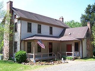
The James Mangum House is a historic home located near Creedmoor, Wake County, North Carolina. Built in 1838, it is an example of Federal architecture. In November 1974, the James Mangum House was listed on the National Register of Historic Places.
Twelve Mile Creek is a waterway located on the Niagara Peninsula in the Regional Municipality of Niagara in Southern Ontario, Canada. Its headwaters are located in the town of Pelham, encompassing some of the most unspoiled and natural areas of Niagara area. The creek's lower reaches flow through urban areas of Thorold and St. Catharines and has been heavily altered by human activity for almost two centuries. The creek was first known as "Ashquasing" by the Mississaugas Indigenous people, the name meaning "that which lies at the end" in the Anishinaabe language.
Gunpowder Falls State Park is a public recreation area comprising six non-contiguous areas covering 18,000 acres (7,300 ha) in northeastern Baltimore County and western Harford County, Maryland. The state park is primarily made up of the stream valleys of the Big and Little Gunpowder Falls and the Gunpowder River; its natural features range from tidal marshes to rugged interior slopes. The park has over 120 miles of trails for hiking, biking, horseback riding, and cross-country skiing plus facilities for picnicking, tubing, canoeing and kayaking, tide-water fishing and crabbing, fly fishing, and hunting, among other activities. It is managed by the Maryland Department of Natural Resources.

Tuckahoe State Park is a public recreation area along Tuckahoe Creek in Caroline and Queen Anne's counties on the Eastern Shore of Maryland, United States. Adkins Arboretum, a garden and preserve maintaining over 600 native plant species, occupies 500 acres of the park. The arboretum provides classes to the public in horticulture, ecology and natural history.

Horseshoe Lake is a 2,007 acres (812 ha) natural oxbow lake in Alexander County, Illinois. It is the site of Illinois's Horseshoe Lake State Fish and Wildlife Area, a state park 10,645 acres (43 km2) in size. It has a 20 miles (32 km) shoreline and a depth of 4 ft (1.2 m), with a maximum depth of 5–6 feet (1.5–1.8 m). A remnant of a large meander of the Mississippi River, it is today a shallow, isolated patch of water located near Cairo and the southern tip of Illinois. In 1972, the Horseshoe Lake Nature Preserve was designated as a National Natural Landmark by the National Park Service.
Northeast Branch Anacostia River is a 3.2-mile-long (5.1 km) free-flowing stream in Prince George's County, Maryland. It is a tributary of the Anacostia River, which flows to the Potomac River and the Chesapeake Bay.
The Beaverdam Creek Archaeological Site,, is an archaeological site located on a floodplain of Beaverdam Creek in Elbert County, Georgia approximately 0.8 km from the creek's confluence with the Savannah River, and is currently inundated by the Richard B. Russell Lake. The site consisted of a platform mound and an associated village site.
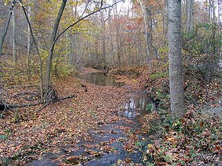
Schumaker Pond is a 35-acre pond created by damming Beaverdam Creek, in Wicomico County, Maryland. The pond is owned by the City of Salisbury and is on the eastern end of the Salisbury City Park. The maximum water depth is 5 feet near the dam, in the old creek channel. In the 1950s-60s Schumaker Pond was popular for swimming, but swimming has since been banned due to the large quantities of E-Coli bacteria in the water. Since then, the pond is often used for fishing.
Parker Pond is a pond in Wicomico County, Maryland formed by a widening of Beaverdam Creek.
The Beaverdam Formation is an upper Pliocene geologic formation on the Delmarva Peninsula in southern Delaware and eastern Maryland. It is the largest major surficial layer on the Delmarva Peninsula and has a lower stream-deposited unit and an upper estuarine unit. These units may represent a cycle of regression and transgression. The Beaverdam Formation is heterogeneous and ranges from very coarse sand with pebbles to silty clay. It unconformably overlies the Manokin or St. Mary's formations and it is up to 75-100 feet thick.
References
- ↑ Gannett, Henry (1904). A Gazetteer of Maryland. Washington, D.C.: U.S. Government Printing Office. p. 14. Retrieved 20 January 2015.
- ↑ SURVEY AND MANAGEMENT OF FRESHWATER FISHERIES RESOURCES (PDF). Maryland Department of Natural Resources. 1994. pp. I-4 through I-6. Archived from the original (PDF) on 23 September 2015. Retrieved 20 January 2015.
- ↑ "City Park – SBY Parks & Recreation Committee" . Retrieved 2020-09-05.