The Potomac River is a major river in the Mid-Atlantic region of the United States that flows from the Potomac Highlands in West Virginia to the Chesapeake Bay in Maryland. It is 405 miles (652 km) long, with a drainage area of 14,700 square miles (38,000 km2), and is the fourth-largest river along the East Coast of the United States and the 21st-largest in the United States. More than 5 million people live within its watershed.

Ray City is a city in Berrien County and Lanier County, Georgia, United States. The population was 956 in 2020.

The Anacostia River is a river in the Mid Atlantic region of the United States. It flows from Prince George's County in Maryland into Washington, D.C., where it joins with the Washington Channel and ultimately empties into the Potomac River at Buzzard Point. It is about 8.7 miles (14.0 km) long. The name "Anacostia" derives from the area's early history as Nacotchtank, a settlement of Necostan or Anacostan Native Americans on the banks of the Anacostia River.

The Catawba River is a major river located in the Southeastern United States. It originates in Western North Carolina and flows into South Carolina, where it later becomes known as the Wateree River. The river is approximately 220 miles (350 km) long. It rises in the Appalachian Mountains and drains into the Piedmont, where it has been impounded through a series of reservoirs for flood control and generation of hydroelectricity. The river is named after the Catawba tribe of Native Americans, which lives on its banks. In their language, they call themselves "yeh is-WAH h’reh", meaning "people of the river."

The Feather River is the principal tributary of the Sacramento River, in the Sacramento Valley of Northern California. The river's main stem is about 73 miles (117 km) long. Its length to its most distant headwater tributary is just over 210 miles (340 km). The main stem Feather River begins in Lake Oroville, where its four long tributary forks join—the South Fork, Middle Fork, North Fork, and West Branch Feather Rivers. These and other tributaries drain part of the northern Sierra Nevada, and the extreme southern Cascades, as well as a small portion of the Sacramento Valley. The total drainage basin is about 6,200 square miles (16,000 km2), with approximately 3,604 square miles (9,330 km2) above Lake Oroville.

The Patapsco River mainstem is a 39-mile (63 km) river in central Maryland that flows into the Chesapeake Bay. The river's tidal portion forms the harbor for the city of Baltimore. With its South Branch, the Patapsco forms the northern border of Howard County, Maryland. The name "Patapsco" is derived from the Algonquian pota-psk-ut, which translates to "backwater" or "tide covered with froth".
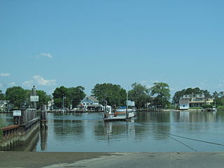
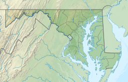
The Wicomico River is a 24.4-mile-long (39.3 km) tributary of the Chesapeake Bay on the eastern shore of Maryland. It drains an area of low marshlands and farming country in the middle Delmarva Peninsula.

Harveys Creek is a tributary of the Susquehanna River in Luzerne County, Pennsylvania, in the United States. It is approximately 14.5 miles (23.3 km) long and flows through Harveys Lake, Lake Township, Lehman Township, Jackson Township, and Plymouth Township. The creek's watershed has an area of 46.3 square miles (120 km2). The creek has four named tributaries, which are known as Bear Hollow Creek, Paint Spring Run, Pikes Creek, and East Fork Harveys Creek. The watershed is designated as a High-Quality Coldwater Fishery and a Migratory Fishery above Pikes Creek and as a Coldwater Fishery and a Migratory Fishery below it. The creek's source is Harveys Lake, the largest natural lake in Pennsylvania.

The Frankstown Branch Juniata River is a 46.0-mile-long (74.0 km) tributary of the Juniata River in Blair and Huntingdon counties, Pennsylvania, in the United States.

The Soque River and its watershed are located entirely within the county boundaries of Habersham County in northeast Georgia. The Soque is a tributary of the Chattahoochee River. Portions of the river run along State Route 197.
Cherryville Township is a township in northwestern Gaston County, North Carolina, United States. As of the 2010 census it had a population of 16,500. It includes the incorporated city of Cherryville, the inactive incorporated town of Dellview, the unincorporated community of Tryon, and a portion of the town of High Shoals. It is represented on the Gaston County Board of Commissioners by Allen Fraley of Cherryville.
The North Fork Clearwater River is a major tributary of the Clearwater River in the U.S. state of Idaho. From its headwaters in the Bitterroot Mountains of eastern Idaho, it flows 135 miles (217 km) westward and is dammed by the Dworshak Dam just above its mouth in north-central Idaho. Draining a rugged watershed of 2,462 square miles (6,380 km2), the river has an average flow of over 5,600 cubic feet per second (160 m3/s), accounting for a third of the discharge from the Clearwater basin. The river drains parts of Clearwater, Shoshone, Latah, and Idaho counties. Most of the watershed is managed by the U.S. Forest Service. Some of the fish of the river include westslope cutthroat trout, rainbow trout, mountain whitefish, and the threatened bull trout. It also has smallmouth bass and a kokanee salmon run, both from Dworshak Reservoir. The North Fork drainage is home to grizzly bears, cougars, deer, moose, black bear, elk, grey wolves, and osprey. The river used to have a large steelhead run before the implementation of Dworshak Dam. The North Fork of the Clearwater is located within the Clearwater National Forest
Schumaker Pond is a 35-acre pond created by damming Beaverdam Creek, in Wicomico County, Maryland. The pond is owned by the City of Salisbury and is on the eastern end of the Salisbury City Park. The maximum water depth is 5 feet near the dam, in the old creek channel. In the 1950s-60s Schumaker Pond was popular for swimming, but swimming has since been banned due to the large quantities of E-Coli bacteria in the water. Since then, the pond is often used for fishing.
Beaverdam Creek is a tributary of the Wicomico River on the Eastern Shore of Maryland. Parker Pond and Schumaker Pond were created by damming Beaverdam Creek.
Pine Creek is a tributary of Solomon Creek in Luzerne County, Pennsylvania, in the United States. It is approximately 3.5 miles (5.6 km) long and flows through Bear Creek Township, Laurel Run, and Hanover Township. The watershed of the creek has an area of 5.00 square miles (12.9 km2). The creek is designated as a Coldwater Fishery and a Migratory Fishery and its watershed is inhabited by several species of macroinvertebrates and fish, including trout. A reservoir known as the Pine Run Reservoir is situated on the creek. It is dammed by the Pine Run Dam Number 1.
Beaverdam Creek or Beaver Dam Creek may refer to:
Partners Creek is a tributary of Tunkhannock Creek in Susquehanna County, Pennsylvania, in the United States. It is approximately 6.4 miles (10.3 km) long and flows through Harford Township and Lenox Township. The watershed of the creek has an area of 5.84 square miles (15.1 km2). The creek has one named tributary, which is known as Sterling Brook. The drainage basin of Partners Creek is classified as a Coldwater Fishery and a Migratory Fishery. The surficial geology in the vicinity of the creek consists of Wisconsinan Till, alluvium, bedrock, wetlands, lakes, and alluvial fan.
The Beaverdam Formation is an upper Pliocene geologic formation on the Delmarva Peninsula in southern Delaware and eastern Maryland. It is the largest major surficial layer on the Delmarva Peninsula and has a lower stream-deposited unit and an upper estuarine unit. These units may represent a cycle of regression and transgression. The Beaverdam Formation is heterogeneous and ranges from very coarse sand with pebbles to silty clay. It unconformably overlies the Manokin or St. Mary's formations and it is up to 75-100 feet thick.