The Wicomico River is a 24.4-mile-long (39.3 km) tributary of the Chesapeake Bay on the eastern shore of Maryland. It drains an area of low marshlands and farming country in the middle Delmarva Peninsula.

The Severn River is a tidal estuary 14 miles (23 km) long, located in Anne Arundel County in the U.S. state of Maryland, south of the Magothy River and north of the South River.

The Chester River is a major tributary of the Chesapeake Bay on the Delmarva Peninsula. It is about 43 miles (69 km) long, and its watershed encompasses 368 sq mi (950 km2), which includes 295 sq mi (760 km2) of land. Thus the total watershed area is 20% water. It forms the border between Kent County and Queen Anne's County, Maryland, with its headwaters extending into New Castle County and Kent County, Delaware. Chestertown, the seat of Maryland's Kent County, is located on its north shore. It is located south of the Sassafras River and north of Eastern Bay, and is connected with Eastern Bay through Kent Narrows.
The Gunpowder River is a 6.8-mile-long (10.9 km) tidal inlet on the western side of Chesapeake Bay in Maryland, United States. It is formed by the joining of two freshwater rivers, Gunpowder Falls and Little Gunpowder Falls.
The Wicomico River is a 13.0-mile-long (20.9 km) tributary of the lower tidal portion of the Potomac River located in the U.S. state of Maryland south of Washington, DC. The river empties into the Potomac at Cobb Island and St. Margaret's Island. Its watershed area is 77 square miles (200 km2), with 2% impervious surface in 1994 in Charles, St. Mary's, and southern Prince George's counties. The lower section of the river forms part of the boundary between Charles and St. Mary's counties. The Wicomico River was designated as a Scenic River under the Maryland Scenic River Act in 1968; Scenic River Commissions oversee it in both Charles and St. Mary's counties.

Mattawoman Creek is a 30.0-mile-long (48.3 km) coastal-plain tributary to the tidal Potomac River with a mouth at Indian Head, Maryland, 20 miles (32 km) downstream of Washington, D.C. It comprises a 23-mile (37 km) river flowing through Prince George's and Charles counties and a 7-mile (11 km) tidal-freshwater estuary in Charles County. About three-fourths of its 94-square-mile (240 km2) watershed lies in Charles County, with the remainder in Prince George's County immediately to the north.

The Elk River is a tidal tributary of the Chesapeake Bay on the Eastern Shore of Maryland and on the northern edge of the Delmarva Peninsula. It is about 15 miles (24 km) long. As the most northeastern extension of the Chesapeake Bay estuary, it has served as one entrance to the Chesapeake & Delaware Canal since the 19th century. The canal and river now serve as one boundary of the Elk Neck Peninsula. The river flows through Cecil County, Maryland, with its watershed extending into New Castle County, Delaware and Chester County, Pennsylvania. Elkton, the county seat of Cecil County, is located at its head. Its total watershed area is 143 square miles (370 km2), with 21 square miles (54 km2) of open water, so its watershed is 15% open water. It is south and east of the North East River, and north of the Sassafras River.
Little Conococheague Creek is a 12.4-mile-long (20.0 km) tributary stream of the Potomac River in the U.S. states of Maryland and Pennsylvania. The stream rises on Two Top Mountain, west of the Whitetail Ski Resort in Franklin County, Pennsylvania, and proceeds south into Washington County, Maryland. It empties into the Potomac about 2 miles (3 km) southeast of Big Spring, Maryland. The watershed of the creek is 18 square miles (47 km2) and includes Indian Springs Wildlife Management Area. Tributaries include Toms Run.
Conowingo Creek is a 20.2-mile-long (32.5 km) tributary of the Susquehanna River in Lancaster County, Pennsylvania and Cecil County, Maryland.

The Northeast River is a tributary of the Chesapeake Bay in Maryland. Entirely tidal, it extends for about 5.0 miles (8.0 km) from the town of North East southwest past Charlestown to the main body of Chesapeake Bay between Carpenter's Point and Red Point. The river is fed by North East Creek and its tributaries, which reach as far north as just east of Nottingham, Pennsylvania. The Northeast River is entirely within Cecil County, Maryland, though its watershed extends into Chester County, Pennsylvania. Its watershed area in MD is 63 square miles (160 km2), with 6% impervious surface in 1994. On the 1612 John Smith map, it was referred to as Gunter's Harbour.
Deer Creek is a 52.9-mile-long (85.1 km) river in Maryland and Pennsylvania that flows through the scenic areas of Harford County and empties into the Susquehanna River, roughly halfway between the Interstate 95 bridge and Conowingo Dam. Its watershed area is 171 square miles (440 km2). Its watershed area in MD is 145 square miles (380 km2), with 3% impervious surface in 1994. It serves as a divider between the agricultural and urban/suburban areas of Harford County.
The Rhode River is a 3-mile-long (5 km) tidal tributary of the West River in Anne Arundel County, Maryland. It is south of the South River.

Curtis Creek is a tidal creek located in Baltimore City and Anne Arundel County, Maryland. It is a tributary of the cove Curtis Bay and is adjacent to the west of the South Baltimore community of Curtis Bay. The creek begins at the confluence of Furnace Creek and Marley Creek in northern Anne Arundel County, Maryland and flows north about 2.5 miles (4.0 km) into Curtis Bay which opens to the east into the main branch and stem of the Patapsco River and Chesapeake Bay.
Ballenger Creek is a 10.7-mile-long (17.2 km) tributary of the Monocacy River in Frederick County, Maryland. The headwaters of the creek are located on the east slope of Catoctin Mountain, about 3 miles (5 km) west of the city of Frederick. The stream runs roughly southeast to the Monocacy National Battlefield and the confluence with the Monocacy River, which drains to the Potomac River. The watershed area of the creek is 21.8 square miles (56 km2).
Winters Run is a 14.6-mile-long (23.5 km) river in Harford County, Maryland. The river begins north of the community of Fallston at the confluence of the West and East Branches, and flows southeast about 11 miles (18 km) to Atkisson Dam in Bel Air. The dam and reservoir were built by the U.S. Army in 1942 to provide an auxiliary fresh water source for nearby Edgewood Arsenal. Upon reaching the tidal line, the river is renamed Otter Point Creek, which empties to Bush River and the Chesapeake Bay. The watershed area of Winters Run is about 56 square miles (150 km2).
The West River is a 6-mile-long (9.7 km) tidal tributary of Chesapeake Bay in southern Anne Arundel County, Maryland. It is south of the Rhode River, which is one of its tributaries, and north of Herring Bay.
Middle River is an estuary in Baltimore County, Maryland, located about 5 miles (8 km) east of the city of Baltimore. The estuary extends from the community of Middle River, north of the Martin Plaza Shopping Center, to the southeast for about 4 miles (6.4 km), to the Chesapeake Bay. The watershed area of Middle River is 12 square miles (31 km2), and includes Martin State Airport.
Back River is a tidal estuary in Baltimore County, Maryland, located about 2 miles (3 km) east of the city of Baltimore. The estuary extends from Essex, Maryland, southeast for about 8.8 miles (14.2 km) to the Chesapeake Bay. The watershed area is 39,075 acres (15,813 ha) and includes Essex Skypark Airport and the Back River Wastewater Treatment Plant. The river is shared between Essex, MD, Dundalk, MD, and Edgemere, MD
Bread and Cheese Creek is a tributary of the Back River in Baltimore County, Maryland. The creek is 3.2 miles (5.1 km) long, with headwaters just east of the Baltimore city line. It flows east through Baltimore County before emptying into the Back River, which flows into the Chesapeake Bay. The watershed area of the creek is 1.85 square miles (4.8 km2).
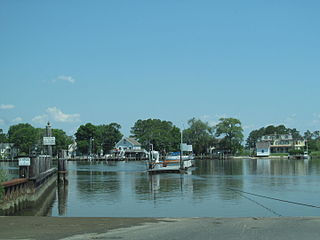
Manokin River is a river in Somerset County, Maryland, that flows into Tangier Sound, an arm of the Chesapeake Bay. The Manokin rises east of Princess Anne, Maryland, flows through the town, then widens into a tidal estuary. Tributaries along the river's 17-mile (27 km) length are Kings Creek, Back Creek, St. Peters Creek, Broad Creek, and Fishing Creek. During the colonial period, the Manokin was navigable as far as Princess Anne.
