Related Research Articles
Frog Creek may refer to the following places in the United States:

The Choptank River is a major tributary of the Chesapeake Bay and the largest river on the Delmarva Peninsula. Running for 71 miles (114 km), it rises in Kent County, Delaware, runs through Caroline County, Maryland and forms much of the border between Talbot County, Maryland on the north, and Caroline County and Dorchester County on the east and south. It is located north of the Nanticoke River and its mouth is located south of Eastern Bay. Cambridge, the county seat of Dorchester County, and Denton, the county seat of Caroline County, are located on its south shore.

The Severn River is a tidal estuary 14 miles (23 km) long, located in Anne Arundel County in the U.S. state of Maryland, south of the Magothy River and north of the South River.
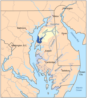
The Chester River is a major tributary of the Chesapeake Bay on the Delmarva Peninsula. It is about 43 miles (69 km) long, and its watershed encompasses 368 sq mi (950 km2), which includes 295 sq mi (760 km2) of land. Thus the total watershed area is 20% water. It forms the border between Kent County and Queen Anne's County, Maryland, with its headwaters extending into New Castle County and Kent County, Delaware. Chestertown, the seat of Maryland's Kent County, is located on its north shore. It is located south of the Sassafras River and north of Eastern Bay, and is connected with Eastern Bay through Kent Narrows.

The Mary River is a major river system located in the South East and Wide Bay–Burnett regions of Queensland, Australia.

The Casselman River is a 56.5-mile-long (90.9 km) tributary of the Youghiogheny River in western Maryland and Pennsylvania in the United States. The Casselman River drains an area of 576 square miles.

Town Creek is a 41.6-mile-long (66.9 km) tributary stream of the Potomac River in the U.S. states of Maryland and Pennsylvania. The creek is formed from the confluence of Sweet Root Creek and Elk Lick Creek, about 0.5 miles (0.8 km) south of Buchanan State Forest in Bedford County, Pennsylvania. Town Creek flows south along the base of Warrior Mountain into Allegany County, Maryland. The Chesapeake and Ohio Canal crosses it at the Town Creek Aqueduct. It empties into the Potomac about 4 miles (6 km) east of Oldtown, Maryland.

Evitts Creek is a tributary stream of the North Branch Potomac River in the U.S. states of Pennsylvania and Maryland. The confluence of Evitts Creek and the North Branch Potomac River is located 2 miles (3 km) east of Cumberland, Maryland.
The Rhode River is a 3-mile-long (5 km) tidal tributary of the West River in Anne Arundel County, Maryland. It is south of the South River.

Battle Creek Cypress Swamp (BCCS) is a forested wetland near Prince Frederick in Calvert County, Maryland, United States. It is one of the northernmost sites of naturally occurring bald cypress trees in North America, and the only large stand of the trees on the western shore of Maryland. In 1965, the National Park Service designated the BCCS a National Natural Landmark.
Coxs Creek, a watercourse of the Cooks River catchment, is located in the Inner West of Sydney, in New South Wales, Australia.
Tuscarora Creek is a 7.7-mile-long (12.4 km) tributary of the Monocacy River in Frederick County, Maryland, in the United States.
Maryland River is a watercourse of the Clarence River catchment in the Northern Tablelands district of New South Wales, Australia. Its upper reaches run close to the border between New South Wales and Queensland.
Middle River is an estuary in Baltimore County, Maryland, located about 5 miles (8 km) east of the city of Baltimore. The estuary extends from the community of Middle River, north of the Martin Plaza Shopping Center, to the southeast for about 4 miles (6.4 km), to the Chesapeake Bay. The watershed area of Middle River is 12 square miles (31 km2), and includes Martin State Airport.
The Big Annemessex River is a 15.4-mile-long (24.8 km) tributary of the Chesapeake Bay on the Delmarva Peninsula. It rises in Kingston, Somerset County, Maryland, and flows roughly southwest about 6 miles (10 km) in a meandering pattern, then widens into an estuary and continues about 9 miles (14 km) to the bay, near Janes Island State Park. Tributaries include Annemessex Creek, Holland Creek, Hall Creek, Muddy Creek, Colbourn Creek, Jones Creek and Daugherty Creek.
Town Creek is a tributary of the Patuxent River in Saint Mary's County, Maryland.

Ciénega Creek is an intermittent stream located in the Basin and Range region of southern Arizona, and is one of the most intact riparian corridors left in the state. It originates in the Canelo Hills and continues northwest about 50 miles (80 km) to an area just outside Tucson, where it becomes known as Pantano Wash. Pantano Wash continues through Tucson and eventually connects with the Rillito River.
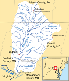
Alloway Creek is a 13.5-mile-long (21.7 km) tributary of the Monocacy River in Pennsylvania and Maryland in the United States. Via the Monocacy River, it is part of the Potomac River watershed.
References
- ↑ "Frog Mortar Creek". Geographic Names Information System . United States Geological Survey . Retrieved June 6, 2011.