Patuxent River

Last updated
Patuxent River
Patuxent tributary/Patuxent affluent
Patuxent.River.jpg
Patuxent River near Bowie
Patuxent River Map.png
Patuxent River drainage basin
Location
CountryUnited States
State Maryland
Cities Columbia, Laurel, Bowie, Upper Marlboro
Physical characteristics
Source 
  location2.3 mi (3.7 km) southwest of Mount Airy, Maryland, U.S.
  coordinates 39°20′55″N77°10′39″W / 39.34861°N 77.17750°W / 39.34861; -77.17750
  elevation823 ft (251 m)
Mouth Chesapeake Bay
  location
2 mi (3.2 km) east of Solomons, Maryland
  coordinates
38°18′43″N76°25′19″W / 38.31194°N 76.42194°W / 38.31194; -76.42194
  elevation
0 ft (0 m)
Length115 mi (185 km)
Basin size908 sq mi (2,350 km2)
Discharge 
  location Laurel, Maryland
  average171 cu ft/s (4.8 m3/s)
  minimum8 cu ft/s (0.23 m3/s)
  maximum2,870 cu ft/s (81 m3/s)
Discharge 
  location Bowie, Maryland
  average647 cu ft/s (18.3 m3/s)
  minimum134 cu ft/s (3.8 m3/s)
  maximum4,500 cu ft/s (130 m3/s)
Basin features
Tributaries 
  left Little Patuxent River
  rightWestern Branch
The Patuxent Wildlife Research Center Patuxent preserve outside.jpg
The Patuxent Wildlife Research Center

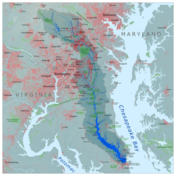
The Patuxent River is a tributary of the Chesapeake Bay in the state of Maryland. There are three main river drainages for central Maryland: the Potomac River to the west passing through Washington, D.C., the Patapsco River to the northeast passing through Baltimore, and the Patuxent River between the two. The 908-square-mile (2,352 km2) [1] Patuxent watershed had a rapidly growing population of 590,769 in 2000. It is the largest and longest river entirely within Maryland, and its watershed is the largest completely within the state.

Contents

Geography

The river source, 115 miles (185 km) from the Chesapeake, is in the hills of the Maryland Piedmont near the intersection of four counties – Howard, Frederick, Montgomery and Carroll, and only 0.6 miles (0.97 km) from Parr's Spring, the source of the south fork of the Patapsco River. Flowing in a generally southeastward direction, the Patuxent crosses the urbanized corridor between Baltimore and Washington, D.C., and opens up into a navigable tidal estuary near the colonial seaport of Queen Anne in Prince George's County, Maryland, just southeast of Bowie. The river is bounded by significant marsh areas for 22 miles (35 km) from the Waysons Corner area to the Hunting Creek confluence. The 52 miles (84 km)-long tidal estuary is never wider than 2.3 miles (3.7 km).

It marks the boundary between Montgomery, Prince George's, Charles and St. Mary's counties on the west and Howard, Anne Arundel, and Calvert counties on the east. The Chesapeake estuary's deepest point, 130 feet (40 m) below sea level, is in the lower Patuxent.

The two largest cities in the watershed are Bowie and Laurel, Maryland. There is a percentage of agricultural activity in the region as well. The mid and lower banks of the river have swamp and marshland ecosystems. Many of those ecosystems are protected by some form of parkland, on the state and local levels. The most notable of which include Jug Bay Wetlands Sanctuary, Merkle Wetlands Sanctuary in the Edgar A. Merkle Wildlife Refuge, [2] [3] and Patuxent River Park, along with many more. Farther north, there is the 20 square mile Patuxent Research Refuge, which helps to protect Patuxent River wildlife.

Tributaries

The Little Patuxent River, the Middle Patuxent River, and the Western Branch are the three largest tributaries. The Middle Patuxent flows into the Little Patuxent just upstream from the historic Savage Mill in Savage. The Little Patuxent then joins the Patuxent just southwest of Crofton. The Middle Patuxent flows 24 miles (39 km) through the middle of Howard County, while the Little Patuxent flows 38 miles (61 km) through northeast and southeast Howard County and western Anne Arundel County. [4] Western Branch originates under the name Folly Branch in the Wingate Drive area of the northern part of Glenn Dale, assuming the name "Western Branch" in Woodmore, continuing southward through Prince George's County, joined by Collington Branch before it joins the Patuxent near Upper Marlboro.

History

View of the River, 1935 Maryland - Odenton through Patuxent - NARA - 23941157 (cropped).jpg
View of the River, 1935

Native Americans have lived along the Patuxent River since at least 1100 BC. [5] An archaeological dig at Pig Point (just north of Jug Bay at the end of Wrighton Road [6] ) uncovered some of the oldest known artifacts in the Mid Atlantic states, [7] including pottery, arrow and spear points, and remnants of wigwams, fires and foodways. The site was probably a center of trade in the region and has one of the best unbroken archaeological records on the East Coast. [7] The Pig Point site includes remnants of the oldest structures ever found in Maryland, wigwam post holes dating to the third century. [7]

The word Patuxent is derived from the Algonquin language used by the indigenous people living in the area prior to the arrival of the European settlers. Its meaning is debated. According to some sources it means "water running over loose stones" [8] while others believe it means the "place where tobacco grows". [9]

The Patuxent River was first named ("Pawtuxunt") on the detailed map resulting from the 1608 voyage upriver by Jamestown, Virginia settler John Smith. [10] Captain Smith got as far as the rough vicinity of the present-day Merkle Wildlife Sanctuary (Lyons Creek) area, 40 miles (60 km) from the Chesapeake near what is now the Anne Arundel–Calvert–Prince George's County tripoint. [11] [12] [13] This was most likely the second visit by Europeans to the Patuxent, as in June 1588 a small Spanish expedition under Vicente Gonzalez is believed to have anchored for the night in the Patuxent mouth. [14] [15] [16] [17] The river was an important colonial shipping port with the government's garrison situated at the mouth of the river where Charles Calvert was first Collector in 1673. [18] [19] In 1699, Thomas Browne, sometimes referred to as 'The Patuxent Ranger', followed the river from the Snowden plantation to where Clarksville is sited. [20] [21] [22] [23] In 1702 George Plater I was the Patuxent naval officer (later based at Sotterley Plantation), [24] having earlier served as Collector after Calvert, Rousby, Sewall, Digges, and Payne held the collectorship. By the mid and late seventeenth century respectively, colonists spread upriver to Mt. Calvert and Billingsley Point, two 18th-century mansions 43.5 miles (70 km) upriver from the Chesapeake that are today part of Patuxent River Park. By 1705, the Snowden iron ore furnace (also known as the Patuxent Iron Works) just southeast of Laurel, [25] [26] was shipping "pig iron" downriver from the current vicinity of the 1783 Montpelier Mansion, also part of Patuxent River Park.

In August 1814, Commodore Joshua Barney and his Chesapeake Bay Flotilla were trapped in the Patuxent by the British fleet under Admiral Sir George Cockburn. To keep them from British hands, Barney's men ignited the magazines of his ships in the four mile (6 km) stretch above Pig Point (44 miles (71 km) upriver from the Chesapeake when the British approached. [27] The British then launched their attack on Washington, D.C., from their warships in the Patuxent at Benedict, 22 miles (35 km) away. From there, the troops marched through Nottingham, Upper Marlboro, Bladensburg, and on to Washington. [28]

Economy and commerce

Tobacco farming dominated the Patuxent's economy for the two centuries following white settlement, with about sixty percent of Maryland's tobacco coming from the Patuxent valley by the late eighteenth century.

Destruction of the plantations by the British and of the soil by centuries of tobacco farming brought the mid and lower Patuxent valley into a period of decline that would last until the 1930s, when there were fewer residents in the Patuxent's Calvert County than there were in the 1840s, and only a few hundred more than in the first Calvert County census in 1790.

The Patuxent was plied by regular steamship service, mostly from the Weems Line, from the 1820s to the 1920s, replacing the schooners and sailing packets that had for the previous centuries served the river's many landings and docks along the 52-mile (84 km) tidal reach.

The Washington Suburban Sanitary Commission constructed two dams on the main branch in the mid-twentieth century. Brighton Dam was constructed 96 miles (154 km) from the Chesapeake in 1943, impounding the waters of Triadelphia Reservoir; in 1952 the T. Howard Duckett Dam was constructed 14 miles (23 km) farther downstream, near Laurel, thus creating Rocky Gorge Reservoir. [29] The land surrounding the two reservoirs is administered by the WSSC, creating a forested reserve of 4,400 acres (18 km2) accessible to the public for horseback riding, hunting, fishing, and picnicking in limited areas. The state of Maryland classifies the T. Howard Duckett Dam as "high hazard" because large releases of water flood areas of North Laurel. [30]

With public recreational land on one or both shores of 74 of the river's 115 miles including the reservoir land, the impact that recreation in natural settings now has on the river's economy is obvious. The Patuxent Naval Air Station at the mouth of the river has continued to grow during past decades along with tourism, providing another main economic engine in the lower river valley that includes the popular boating center of Solomons.

The Patuxent River is the sole known source for Maryland's State Gemstone. [31]

Environmental concerns

According to EcoHealth Report Cards, the Patuxent River has a below average health rating, scoring a 38%, compared to the Chesapeake's over all health rating of 54%, as of 2016. However, the river does have higher ratings in dissolved oxygen, and likely, will soon have higher ratings in phosphorus. [32]

The Middle and Little Patuxent watersheds include nearly all of Columbia, Maryland, including its downtown urban Lake Kittamaqundi and Wilde Lake. Columbia is a large planned community in Howard County that opened in 1967. Columbia's major downtown roadway is called Little Patuxent Parkway, and Maryland Route 175 in East Columbia was known as the Patuxent Parkway until May 2006, when it was renamed for Columbia's founder, the late James Rouse, and his wife, Patty. It was the largely unchecked erosion from this late 1960s and 1970s building spree that contributed the bulk of the Patuxent River's highest and most damaging sediment, siltation, and pollution levels to date downstream. This in turn led to a nearly complete destruction of a once thriving seafood industry along the brackish portion of the river.

"The Patuxent River has known no greater friend, advocate, and defender than Bernie Fowler." [33] Fowler, as an early-1970s Calvert County commissioner, led the way in a lawsuit filed by downriver Charles, Calvert and St. Mary's counties against upriver counties. The lawsuit forced the state, the upriver counties, and the U.S. Environmental Protection Agency to enact pollution control measures. Between 1985 and 2005, the Patuxent saw a 26% decrease in nitrogen, a 46% decrease in phosphorus, and a 35% reduction in sediment, despite urban areas increasing to 31% of the watershed by 2002. Of the Chesapeake's major tributaries, the Patuxent is the only one having most of its harmful phosphorus and nitrogen nutrient overloads coming from urban runoff. The river's other two largest contributors, point sources (industrial, sewage, etc.) and the declining (24%) agricultural areas, contribute less of the nutrient load. Forested areas account for 43% of the watershed. [34] [35]

In 2004, Fred Tutman became the first "Riverkeeper" for the Patuxent. [36] The mission of the Patuxent Riverkeeper organization, a member of the worldwide Waterkeeper Alliance, is to protect and improve the quality of the river's water and watershed and provide access and education at its facility in Nottingham. [37]

Over the past 50 years, nationally recognized land preservation efforts in this part of Maryland have saved tens of thousands of acres from the Baltimore-Washington bedroom community sprawl. The southern half of the U.S. Army's Fort Meade was added to the Patuxent Wildlife Research Center, which, at 12,300 acres (50 km2), is the second largest contiguous public park-refuge within 30 miles (50 km) of either Washington or Baltimore. It is located midway between these two cities. The contiguous public area of 8,575 acres (35 km2) centered on Jug Bay, 42 miles (68 km) upriver from the Chesapeake, form the fifth largest such Baltimore-D.C. preserve and largest tidewater one and consist of the Jug Bay Wetlands Sanctuary, the Merkle Wildlife Sanctuary, and the Jug Bay component of the Patuxent River Park. The 6,600-acre (27 km2) Patuxent River State Park in the uppermost part of the basin is the seventh largest.

Aerial photograph of the Patuxent River forming the boundary of Calvert County (foreground) and Prince George's County Patuxent River 20201109.jpg
Aerial photograph of the Patuxent River forming the boundary of Calvert County (foreground) and Prince George's County

Chesapeake Bay Week video releases, 2022

On 20 April 2022, PBS released a 26 minute documentary: "Troubled Tributary: Maryland's Patuxent River" - The Patuxent River is a crucial tributary of the Chesapeake Bay. Despite the central role the river has played in the history of the Bay's environmental movement and abundant conservation resources funneled to it over the years, it remains polluted. Its riverkeeper, Fred Tutman, believes that environmental injustice exists along its banks.

On 21 April 2022, PBS released a 56 minute special: "The Chesapeake Bay Summit 2022" - Experts, scientists and policy makers converge for a compelling discussion on the health of the Chesapeake Bay watershed, led by host Frank Sesno.

Bridges

CrossingCarriesLocationCoordinates
Montgomery County – Howard County
MD 27 bridgeMD Route 27.svg MD 27 (Ridge Road)Southwest of Mt. Airy
Windsor Forest Road bridgeWindsor Forest RoadSouthwest of Mt. Airy
Long Corner Road bridgeLong Corner Road Damascus
MD 94 bridgeMD Route 94.svg MD 94 (Annapolis Rock Road/Woodbine Road) Damascus
Mullinix Mill Road bridgeMullinix Mill Road Damascus
Hipsley Mill Road bridgeHipsley Mill Road Etchison
Howard Chapel Road bridgeHoward Chapel Road Unity
MD 97 bridgeMD Route 97.svg MD 97 ( Georgia Avenue /Roxbury Mills Road)North of Brookeville
Triadelphia Reservoir Brighton Dam Road Brookeville
Clarksville
39°12′27″N77°00′48″W / 39.207517°N 77.013302°W / 39.207517; -77.013302
Haviland Mill Road bridgeHaviland Mill Road Brinklow
Mink Hollow Road bridgeMink Hollow Road Brinklow
Snell's Bridge MD Route 108.svg MD 108 (Ashton Road/Clarksville Pike) Ashton
Highland
Brown's BridgeEdnor Road/Browns Bridge Road Ashton
Highland
US 29 bridge over Rocky Gorge Reservoir US 29.svg US 29 (Columbia Pike)North of Burtonsville
Prince George's County – Howard County
I-95 bridge near T. Howard Duckett Dam I-95.svg I-95 Laurel
MD 216 bridgeMD Route 216.svg MD 216 (7th Street) Laurel
US 1 bridgesUS 1.svg US 1 (Washington Boulevard, southbound traffic; 2nd Street, northbound traffic) Laurel
Howard County – Prince George's County – Anne Arundel County
B&O bridge CSX Capital Subdivision Laurel
Prince George's County – Anne Arundel County
MD 198 bridgeMD Route 198.svg MD 198 (Laurel Fort Meade Road) Laurel
Brock Bridge Road bridgeBrock Bridge Road Laurel
Baltimore–Washington Parkway bridge Baltimore-Washington Parkway Laurel
Duval Bridge
(not open to public vehicular traffic)
Old Telegraph Road (Lago Road) Patuxent Wildlife Research Center
Northeast Corridor bridge Amtrak Northeast Corridor Bowie (near Bowie State University)
Priest BridgeMD Route 3.svgMD Route 450.svg MD 3  / MD 450 (Robert Crain Highway) Bowie
Crofton
US 50 bridgeI-595.svgUS 50.svgUS 301.svg I-595  / US 50  / US 301 (John Hanson Highway) Davidsonville
Governor's Bridge Governor Bridge Road Davidsonville 39°00′24″N76°46′46″W / 39.00667°N 76.77944°W / 39.00667; -76.77944
MD 214 bridgeMD Route 214.svg MD 214 (Central Avenue) Queen Anne
Queen Anne Bridge
(closed in 2007 to all use)
Queen Anne Bridge Road Queen Anne 38°53′42.65″N76°40′34.65″W / 38.8951806°N 76.6762917°W / 38.8951806; -76.6762917
Hills BridgeMD Route 4.svg MD 4 ( Pennsylvania Avenue ) Upper Marlboro
Calvert CountyCharles County
Benedict Bridge MD Route 231.svg MD 231 Benedict
Calvert CountySt. Mary's County
Governor Thomas Johnson Bridge MD Route 4.svg MD 4 Solomons 38°19′34.7″N76°28′17.23″W / 38.326306°N 76.4714528°W / 38.326306; -76.4714528


See also

Related Research Articles

<span class="mw-page-title-main">Calvert County, Maryland</span> County in Maryland, United States

Calvert County is a county located in the U.S. state of Maryland. As of the 2020 census, the population was 92,783. Its county seat is Prince Frederick. The county's name is derived from the family name of the Barons of Baltimore, the proprietors of the English Colony of Maryland. Calvert County is included in the Washington–Arlington–Alexandria, DC–VA–MD–WV Metropolitan Statistical Area. It occupies the Calvert Peninsula, which is bordered on the east by Chesapeake Bay and on the west by the Patuxent River. Calvert County is part of the Southern Maryland region. The county has one of the highest median household incomes in the United States. It is one of the older counties in Maryland, after St. Mary's, Kent County and Anne Arundel counties.

<span class="mw-page-title-main">Anne Arundel County, Maryland</span> County in Maryland, United States

Anne Arundel County, also notated as AA or A.A. County, is located in the U.S. state of Maryland. As of the 2020 United States census, its population was 588,261, an increase of just under 10% since 2010. Its county seat is Annapolis, which is also the capital of the state. The county is named for Anne Arundell, Lady Baltimore, a member of the ancient family of Arundells in Cornwall, England, and the wife of Cecilius Calvert, 2nd Baron Baltimore (1605–1675), founder and first lord proprietor of the colony Province of Maryland.

<span class="mw-page-title-main">Patapsco River</span> River in Maryland, United States

The Patapsco River mainstem is a 39-mile (63 km) river in central Maryland that flows into the Chesapeake Bay. The river's tidal portion forms the harbor for the city of Baltimore. With its South Branch, the Patapsco forms the northern border of Howard County, Maryland. The name "Patapsco" is derived from the Algonquian pota-psk-ut, which translates to "backwater" or "tide covered with froth."

<span class="mw-page-title-main">Southern Maryland</span> Place in Maryland, United States

Southern Maryland, also referred to as SoMD, is a geographical, cultural and historic region in Maryland composed of the state's southernmost counties on the Western Shore of the Chesapeake Bay. According to the state of Maryland, the region includes all of Calvert, Charles, and St. Mary's counties and the southern portions of Anne Arundel and Prince George's counties. It is largely coterminous with the region of Maryland that is part of the Washington metropolitan area. Portions of the region are also part of the Baltimore Metropolitan Area and the California-Lexington Park Metropolitan Statistical Area. As of the 2020 Census, the region had a population of 373,177. The largest community in Southern Maryland is Waldorf, with a population of 81,410 as of the 2020 Census.

<span class="mw-page-title-main">Severn River (Maryland)</span> River in Maryland, United States

The Severn River is a tidal estuary 14 miles (23 km) long, located in Anne Arundel County in the U.S. state of Maryland, south of the Magothy River and north of the South River.

<span class="mw-page-title-main">Mattawoman Creek</span> Coastal plain tributary in Maryland, United States

Mattawoman Creek is a 30.0-mile-long (48.3 km) coastal-plain tributary to the tidal Potomac River with a mouth at Indian Head, Maryland, 20 miles (32 km) downstream of Washington, D.C. It comprises a 23-mile (37 km) river flowing through Prince George's and Charles counties and a 7-mile (11 km) tidal-freshwater estuary in Charles County. About three-fourths of its 94-square-mile (240 km2) watershed lies in Charles County, with the remainder in Prince George's County immediately to the north.

<span class="mw-page-title-main">Jug Bay Wetlands Sanctuary</span> Wildlife sanctuary in southern Maryland, US

The Jug Bay Wetlands Sanctuary is located along the tidal Patuxent River in southern Maryland, United States. It was established in 1985 and is operated by the Anne Arundel County Department of Recreation and Parks. It includes more than 1,700 acres (6.9 km2) of tidal freshwater wetlands, forests, meadows and fields. The wetlands, with large stands of aquatic plants including wild rice, are home to many birds, fish, reptiles, amphibians, and mammals. Miles of trails and boardwalks traverse a variety of habitats and provide glimpses into the rich history of the region. Notably, archaeologists have uncovered evidence of a large Native American settlement at Jug Bay which spanned 2 miles along the Patuxent, with the oldest arrowhead-like artifact dated between 8,000 to 8,900 years old.

The Magothy River runs 12.1 miles (19.5 km) through Anne Arundel County in the U.S. state of Maryland. It is located south of the Patapsco River and north of the Severn River. There are two public park paddling access points, Beachwood Park on the north shore a half mile east of the Magothy Bridge Road bridge, and Spriggs Farm Park off Bayberry Drive, on the south shore two miles west of the Magothy's mouth. Both are Anne Arundel County parks.

The South River is a 10-mile-long (16 km) tributary of the Chesapeake Bay in Anne Arundel County, Maryland in the United States. It lies south of the Severn River, east of the Patuxent River, and north of the West River and Rhode River, and drains to the Chesapeake Bay.

<span class="mw-page-title-main">Chesapeake Beach Rail Trail</span> Set of trails in Maryland and the District of Columbia

The Chesapeake Beach Rail Trail is a set of short trails along the original Chesapeake Beach Railway route from Washington, D.C. to Chesapeake Beach, Maryland. The Maryland-National Capital Park and Planning Commission (M-NCPPC) acquired portions of the corridor through the subdivision process. Some sections have already been built. Plans call for future sections to be built as available until this corridor serves as the spine for a number of greenway branches.

The Rhode River is a 3-mile-long (5 km) tidal tributary of the West River in Anne Arundel County, Maryland. It is south of the South River.

<span class="mw-page-title-main">Bernie Fowler</span> American politician (1924–2021)

Clyde Bernard Fowler was an American politician from Maryland. He was a Calvert County Commissioner from 1970 to 1982, and served in the Maryland Senate between 1983 and 1994. Fowler is best known for his advocacy for the cleanup of the Patuxent River, the largest river to be found entirely within the State of Maryland.

<span class="mw-page-title-main">Watts Branch (Anacostia River tributary)</span> River in Maryland, Maryland

Watts Branch is a tributary stream of the Anacostia River in Prince George's County, Maryland, and Washington, D.C.

Bristol is an unincorporated community in Anne Arundel County, Maryland, United States. Jug Bay Wetlands Sanctuary and the colonial town of Pig Point are on the Patuxent River waterfront portion of Bristol. Pig Point saw War of 1812 action and was the county's largest steamboat port on the Patuxent in the mid-19th century. Pig Point is a very significant Native American Early Archaic Period archaeological site.

The West River is a 6-mile-long (9.7 km) tidal tributary of Chesapeake Bay in southern Anne Arundel County, Maryland. It is south of the Rhode River, which is one of its tributaries, and north of Herring Bay.

Town Creek is a tributary of the Patuxent River in Saint Mary's County, Maryland.

Zekiah Swamp is part of the Potomac River basin in Charles County, Maryland in the United States. The swamp is 21 miles (34 km) of braided stream stretching the length of Charles County and is a tributary of the Potomac River. It sits at an elevation of three feet (0.91 m) and 450 acres (180 ha) of its southern end is protected as the Zekiah Swamp Natural Environment Area. The Maryland Department of Natural Resources has the authority to purchase an additional 5,000 acres (2,000 ha) for the park. Charles County has moved to protect an additional 65,000 acres (26,000 ha) of the wetland. The headwaters of the swamp are protected as part of Cedarville State Forest. It was first accurately surveyed by John Henry Alexander, Maryland's official cartographer, in 1835, as "Allen's Fresh".

The Broadneck Peninsula is an area in Anne Arundel County, Maryland. The area is north of the Severn River, south of the Magothy River and west of the Chesapeake Bay. At the lower end of the Broadneck Peninsula is the 4.3 mile Chesapeake Bay Bridge.

The Green Branch of the Patuxent River in Prince George's County, Maryland is part of the Upper Patuxent Watershed. The stream passes centrally through the Governor Bridge Natural Area / Patuxent River Park and joins the Patuxent, just south of Governor's Bridge.

References

  1. Costanza, Robert; et al. (2002-05-01). "Integrated Ecological Economic Modeling of the Patuxent River Watershed, Maryland". Ecological Monographs. pp. 203–231. Retrieved 2018-08-27.
  2. Meyer, Eugene L., The Legacy of Edgar Merkle: Canada Geese on the Patuxent, The Washington Post, August 18, 1984
  3. https://web.archive.org/web/20100815073135/http://www.dnr.state.md.us/publiclands/southern/merkle.asp Merkle Wildlife Refuge web site
  4. U.S. Geological Survey. National Hydrography Dataset high-resolution flowline data. The National Map, accessed April 1, 2011
  5. Dr. Zachary Singer. "Unearth Lost Towns with Archaeologists". Atlas Obscura. Retrieved 2020-04-18.
  6. Pig Point Archaeology Site, at the end of Wrighton Road, Bristol, via Google Maps
  7. 1 2 3 "Amazing artifacts unearthed at Pig Point", E.B. Furgurson III, The Archaeology News Network, April 2011. Original source: The Capital [April 17, 2011]
  8. Patuxent Riverkeeper - About the river: http://paxriverkeeper.org/about-the-river/
  9. Stein Charles Francis. 19771976. A History of Calvert County Maryland. 3d ed. Baltimore Md: Published by the author in cooperation with the Calvert County Historical Society. page 2
  10. Smith, John (2006). The Generall Historie of Virginia, New-England, and the Summer Isles... (Electronic ed.). University of North Carolina at Chapel Hill. Retrieved 2007-10-29.
  11. John S. Salmon (2006-05-09). "Captain John Smith Chesapeake National Historic Water Trail – Statement of National Significance" (PDF). Chesapeake Bay Gateways Network. p. 136. Retrieved 2007-12-04.
  12. Wayne E. Clark (2005). "Indians in Maryland, An Overview". Maryland Online Encyclopedia. Retrieved 2007-12-04.
  13. "John Smith's Second Chesapeake Voyage". Chesapeake Bay Gateways Network. 2006. Retrieved 2007-12-04.
  14. Loker, Aleck (2006). Walter Raleigh's Virginia. Williamsburg, VA: Solitude Press. p. 108. ISBN   1-928874-08-8.
  15. "Author Biography for Closed Sea by Kent Mountford". 2005.
  16. John S. Salmon (2006-05-09). "Captain John Smith Chesapeake National Historic Water Trail – Statement of National Significance" (PDF). Chesapeake Bay Gateways Network. Retrieved 2007-12-03.
  17. U.S. Army Engineer Water Resources Support Center (January 1983). "History of the Waterways of the Atlantic Coast of the United States (NWS 83-10) – Chronology" (PDF). U. S. Army Corps of Engineers. Archived from the original (PDF) on 2007-08-24. Retrieved 2007-12-03.
  18. Maryland Archaeological Conservation Laboratory. "Mattapany (18ST390)". Data from the Colonial Encounters project. Colonial Encounters website www.colonialencounters.org Retrieved 11 March 2019.
  19. "Archives of Maryland Historical List Collectors, 1673-1776." Source: Edward C. Papenfuse, et al., Archives of Maryland, Historical List, new series, Vol. 1. Annapolis, MD: Maryland State Archives, 1990. Maryland State Archives website Retrieved 11 March 2019.
  20. Howard's Roads to the Past. Howard County Sesquicentennial Celebration Committee, 2001. 2001. p. 2.
  21. Joshua Dorsey Warfield. The founders of Anne Arundel and Howard Counties, Maryland. p. 337.
  22. Hester Dorsey Richardson. Side-lights on Maryland History: With Sketches of Early Maryland, Volume 2. p. 290.
  23. Frederick Adams Virkus, Albert Nelson Marquis. The Compendium of American Genealogy: First Families of America; the Standard Genealogical Encyclopedia of the United States, Volume 7. A. N. Marquis, 1942.
  24. "America and West Indies: October 1702, 6-10." Calendar of State Papers Colonial, America and West Indies: Volume 20, 1702. Ed. Cecil Headlam. London: His Majesty's Stationery Office, 1912. 650-653 British History Online website. Retrieved 11 March 2019.
  25. Robert C. Chidester. "A Historic Context for the Archaeology of Industrial Labor in the State of Maryland". The Center for Heritage Resource Studies, University of Maryland. Retrieved 2007-10-01.
  26. Peter M. Kranz. Notes on the Sedimentary Iron Ores of Maryland and their Dinosaurian Fauna. Appendix B: University of Maryland. Retrieved 2007-10-01.
  27. Shomette, Donald (1982). Shipwrecks on the Chesapeake. Centreville, Maryland: Tidewater Publishers. pp.  87–93. ISBN   0-87033-283-X.
  28. Ross, Gen. (October 1814). "Dispatch from Gen. Ross". The Gentleman's Magazine, London Gazette Extraordinary. Original from the University of Michigan, Digitized by Google: E. Cave. v.84 pt.2: 372. Retrieved 2007-10-30.
  29. Washington Suburban Sanitary Commission. Laurel, Maryland (2007). "The WSSC-- A Thumbnail History", Accessed 2010-02-15.
  30. Maryland Department of the Environment. Baltimore, Maryland (2006). "Maryland Dams Endure Dramatic Rainfall", eMDE (online newsletter). V.2, No. 6, October 2006.
  31. "Maryland State Gemstone: Patuxent River Stone (Agate)".
  32. "Health | EcoHealth Report Cards". EcoReportCard. Retrieved 2018-03-15.
  33. "Bernie Fowler Wade-in Draws Attention to Patuxent Water Quality". Chesapeake Bay Program. 2007-06-14. Retrieved 2007-12-04.
    Quote attributed to Congressman Steny Hoyer.
  34. Tidewater Ecosystem Assessment Office (2007-08-01). "Maryland Tributary Strategy: Patuxent River Basin Summary Report for 1985–2005 Data" (PDF). Maryland Department of Natural Resources. pp. 3, 6. Retrieved 2007-12-06.
  35. Karl Blankenship (January 2007). "Bay Journal: Chesapeake Cleanup Update – River Basin Overviews(Patuxent)" (PDF). Alliance for the Chesapeake Bay. Retrieved 2007-12-06.
  36. Patuxent River Commission (2004). "Summary of June 2004 Meeting Minutes" (PDF). Retrieved 2007-12-05.
  37. "Patuxent Riverkeeper – Clean water advocates serving people & communities since 2004". www.paxriverkeeper.org. Retrieved 2018-03-15.