
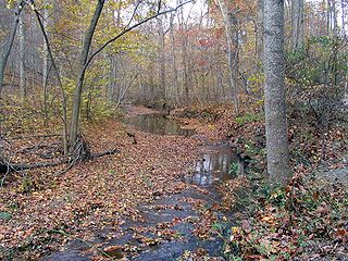
Tenmile Creek is a tributary stream of Little Seneca Creek in Montgomery County, Maryland. [1]
Tenmile Creek is a tributary stream of Little Seneca Creek in Montgomery County, Maryland. [1]
The headwaters of the stream originate in Thompsons Corner area of the county, about 2 miles (3.2 km) northwest of Clarksburg, and the creek flows south for about 2.5 miles (4.0 km), to Little Seneca Lake, a reservoir built on Little Seneca Creek. Little Seneca Creek drains to the Potomac River and the Chesapeake Bay.
The Tenmile Creek watershed is described as one of the highest quality stream systems in Montgomery County, according to government studies. [2] [3] :156 It is a drinking water source as part of the Little Seneca system, an emergency water supply for the metropolitan Washington, D.C. area. [4] The creek main stem is extensively forested and the watershed contains some agricultural land. However, the basin is bisected by an interstate highway, I-270, and in the late 1980s the county began planning for additional land development in the Clarksburg area. [3] :156 [5]
In 1994 the county government had designated a portion of the watershed as a "special protection area" (SPA) to protect water quality by requiring builders to install extensive controls for stormwater runoff. [3] :156–159 [6] A follow-up study found that after construction of several projects, water quality in the Little Seneca basin was degraded, despite the SPA requirements. [7] In April 2014, the Montgomery County Council set additional limits on development projects in order to protect the quality of the creek and adjacent habitat. [3] :173–175 [8] [9] Later that year, developers filed suit against the county, claiming that the county "illegally limited construction on its property." [10] The U.S. District Court in Maryland dismissed the suit in August 2017. [11] The district court's dismissal was affirmed by the Fourth Circuit Court of Appeals on November 29, 2018. [12]
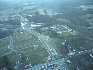
Clarksburg is a census-designated place and an unincorporated area in northern Montgomery County, Maryland, United States. It is located at the northern end of the Interstate 270 technology corridor, approximately four miles north of Germantown. As of 2016, Clarksburg had an estimated population of 20,441.

Darnestown is a United States census-designated place (CDP) and an unincorporated area in Montgomery County, Maryland. The CDP is 17.70 square miles (45.8 km2) with the Potomac River as its southern border and the Muddy Branch as much of its eastern border. Seneca Creek borders portions of its north and west sides. The Travilah, North Potomac, and Germantown census-designated places are adjacent to it, as is the city of Gaithersburg. Land area for the CDP is 16.39 square miles (42.4 km2). The Darnestown CDP has a population of approximately 6,400, while the village of Darnestown is considerably smaller in size and population. Washington, D.C. is about 25 miles (40 km) away.

Sligo Creek is a free-flowing tributary of the Northwest Branch of the Anacostia River in Maryland. The creek is approximately 9.1 miles (14.6 km) long, with a drainage area of about 11.6 square miles (30 km2).

Rock Creek is a free-flowing tributary of the Potomac River that empties into the Atlantic Ocean via the Chesapeake Bay. The 32.6-mile (52.5 km) creek drains about 76.5 square miles (198 km2). Its final quarter-mile is affected by tides.
The Little Monocacy River is a 10.1-mile-long (16.3 km) tributary stream of the Potomac River. Despite its name, the stream does not feed into the Monocacy River. The Little Monocacy is located almost entirely in Montgomery County, Maryland, and enters the Potomac just downstream from where the Monocacy enters the Potomac. Its headwaters rise southwest of Comus, and most of its approximately 17-square-mile (44 km2) watershed is farmland and pasture (60.56%) or forested land (36.03%).

Seneca Creek is a 5.8-mile-long (9.3 km) stream in Montgomery County, Maryland, USA, roughly 16 miles (26 km) northwest of Washington, D.C. It drains into the Potomac River.

Maryland Route 355 (MD 355) is a 36.75-mile (59.14 km) north–south road in western central Maryland in the United States. The southern terminus of the route, Wisconsin Avenue, is located in the Bethesda CDP, at the Washington, D.C. border. It continues south into Washington, D.C. as Wisconsin Avenue NW. The northern terminus is just north of an overpass with Interstate 70 (I-70)/U.S. Route 40 (US 40) in the city of Frederick in Frederick County, where the road continues north as Market Street through Frederick towards MD 26.
Cabin John Creek is a tributary stream of the Potomac River in Montgomery County, Maryland. The watershed covers an area of 26 square miles (67 km2). The headwaters of the creek originate in the city of Rockville, and the creek flows southward for 10.9 miles (17.5 km) to the Potomac River.

Little Falls Branch, a 3.8-mile-long (6.1 km) tributary stream of the Potomac River, is located in Montgomery County, Maryland. In the 19th century, the stream was also called Powder Mill Branch. It drains portions of Bethesda, Somerset, Friendship Heights, and the District of Columbia, flows under the Chesapeake and Ohio Canal (C&O), and empties into the Potomac at Little Falls rapids, which marks the upper end of the tidal Potomac.

Watts Branch is a tributary stream of the Potomac River in Montgomery County, Maryland.
Hawlings River is a 12.9-mile-long (20.8 km) tributary of the Patuxent River in Montgomery County, Maryland. The watershed covers an area of about 28 square miles (73 km2). The waterway was originally called Holland's River. The headwaters of the river originate in the area north of Laytonsville, and the river flows southeast, entering the Patuxent about 1.5 miles (2.4 km) below the Triadelphia Reservoir. Portions of Hawlings River flow through Rachel Carson Conservation Park and Hawlings River Stream Valley Park. Tributaries of the Hawlings River include Mount Zion Tributary, Reddy Branch, Olney Mill Tributary, Gregg Tributary, and James Creek. The river and its tributaries total about 98 miles (158 km) of streams.

Little Seneca Lake is a reservoir located near the Boyds community in Montgomery County, Maryland.
Broad Run is a tributary stream of the Potomac River in Montgomery County, Maryland. The headwaters of the stream originate west of the town of Poolesville, and the creek flows southward for 8.9 miles (14.3 km) to the Potomac River. The Broad Run and its watershed are almost entirely within the Montgomery County Agricultural Reserve.

Maryland Route 119 is a state highway in the U.S. state of Maryland. Also known as Great Seneca Highway, the highway runs 7.47 miles (12.02 km) from MD 28 in Rockville north to Middlebrook Road in Germantown. MD 119 is a four- to six-lane divided highway that connects several residential and commercial neighborhoods in Rockville, Gaithersburg, and Germantown. Great Seneca Highway was planned by Montgomery County in the late 1960s as a local relief route for traffic on parallel Interstate 270 (I-270) between the three communities. By the early 1980s, the highway had become controversial because it was proposed to pass through Seneca Creek State Park. A coalition of civic and environmental groups unsuccessfully pursued litigation to stop the highway. The National Park Service refused permission for the county to build the highway in 1985 but reversed itself two years later, by which time the first segment of the highway in Germantown was nearing completion. The Rockville–Gaithersburg section was completed in 1989 and the controversial segment through the state park was finished in 1990. Almost all of Great Seneca Highway became MD 119 in 1999.

Maryland Route 121 is a state highway in the U.S. state of Maryland. Known as Clarksburg Road, the highway runs 3.96 miles (6.37 km) from MD 117 in Boyds north to Stringtown Road between Interstate 270 (I-270) and MD 355 in Clarksburg. MD 121 connects Boyds and Clarksburg in northern Montgomery County. The highway was paved from Clarksburg to Boyds in the early to mid-1910s. MD 121 was extended to north of Clarksburg in the late 1920s and early 1930s. MD 121 was relocated through Clarksburg in the mid-1950s when I-270 was constructed through the area. The highway's northern end was rolled back to MD 355 in the mid-1970s. MD 121 was relocated in Boyds in the mid-1980s. The highway's northern end was moved to its present terminus just north of I-270 when Stringtown Road was constructed in the mid-2000s. In addition to the Boyds–Clarksburg route, MD 121 has also included three disjoint segments in Dawsonville and Germantown. All three of these routes were segments of the original MD 119.

Little Seneca Creek is an 14.0-mile-long (22.5 km) stream in Montgomery County, Maryland, roughly 18 miles (29 km) northwest of Washington, D.C.
Back River is a tidal estuary in Baltimore County, Maryland, located about 2 miles (3 km) east of the city of Baltimore. The estuary extends from the community of Rosedale, southeast for about 8.8 miles (14.2 km) to the Chesapeake Bay. The watershed area is 39,075 acres (15,813 ha) and includes Essex Skypark Airport and the Back River Wastewater Treatment Plant.

Northwest Branch Anacostia River is a 21.5-mile-long (34.6 km) free-flowing stream in Montgomery County and Prince George's County, Maryland. It is a tributary of the Anacostia River, which flows to the Potomac River and the Chesapeake Bay.

Northeast Branch Anacostia River is a 3.2-mile-long (5.1 km) free-flowing stream in Prince George's County, Maryland. It is a tributary of the Anacostia River, which flows to the Potomac River and the Chesapeake Bay.

Marc Elrich is an American politician and County Executive of Montgomery County, Maryland. He was formerly an at-large member of the Montgomery County Council, first elected in 2006. Prior to that he served on the Takoma Park City Council for 19 years, representing Ward 5 which covers and incorporates the greater Long Branch / East Silver Spring area.
Coordinates: 39°11′14″N77°18′14″W / 39.1873282°N 77.3038732°W