
Whitesburg is a town in Carroll County, Georgia, United States. The population was 596 at the 2000 census.

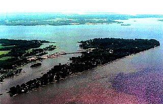
Deale is a census-designated place (CDP) in Anne Arundel County, Maryland, United States. The population was 4,945 at the 2010 census. It has a scenic view of Chesapeake Bay and is popular with boaters. Sudley was listed on the National Register of Historic Places in 1973.

Sligo is a borough in Clarion County, Pennsylvania, United States. The population was 720 at the 2010 census.

Sandy Creek is a village in Oswego County, New York, United States. The population was 771 at the 2010 census.
The Wicomico River is a 13.0-mile-long (20.9 km) tributary of the lower tidal portion of the Potomac River located in the U.S. state of Maryland south of Washington, DC. The river empties into the Potomac at Cobb Island and St. Margaret's Island. Its watershed area is 77 square miles (200 km2), with 2% impervious surface in 1994. in Charles, St. Mary's, and southern Prince George's counties. The lower section of the river forms part of the boundary between Charles and St. Mary's counties. The Wicomico River was designated a Scenic River under the Maryland Scenic River Act in 1968, and there are Scenic River Commissions for it in both Charles and St. Mary's counties.
Coordinates: 38°11′29″N76°54′16″W
Elk Creek is an 11.4-mile-long (18.3 km) tributary of Loyalsock Creek in Sullivan County, Pennsylvania in the United States.
Codorus Creek is a 42.4-mile-long (68.2 km) tributary of the Susquehanna River in York County, Pennsylvania in the United States.
Deer Creek is a 52.9-mile-long (85.1 km) river in Maryland that flows through the scenic areas of Harford County and empties into the Susquehanna River, roughly halfway between the Interstate 95 bridge and Conowingo Dam. Its watershed area is 171 square miles (440 km2). Its watershed area in MD is 145 square miles (380 km2), with 3% impervious surface in 1994. It serves as a divider between the agricultural and urban/suburban areas of Harford County.
The Rhode River is a 3-mile-long (5 km) tidal tributary of the West River in Anne Arundel County, Maryland. It is south of the South River.
Little Chiques Creek is a 20.6-mile-long (33.2 km) tributary of Chiques Creek in Lancaster County, Pennsylvania in the United States.
Popes Creek is a 3.4-mile-long (5.5 km) stream in Charles County, Maryland and a tributary of the Potomac River.
Lyons Creek is an 11.2-mile-long (18.0 km) tributary of the Patuxent River in Maryland. Lyons Creek serves as the borider between southern Anne Arundel County, Maryland and northern Calvert County, Maryland.

Paint Branch is a 14.0-mile-long (22.5 km) stream that flows through Montgomery County and Prince George's County, Maryland. It is a tributary of the Northeast Branch, which flows to the Anacostia River, Potomac River and the Chesapeake Bay.
Grassy Creek No. 78 is a rural municipality in the Canadian province of Saskatchewan.It is also located in the Census division No. 4.

Detters Mill was a small 19th-century community in Dover Township, York County, Pennsylvania, about 2.5 miles (4.0 km) south of Wellsville, and 17 miles (27 km) southwest of Harrisburg.
The Nowood River is a river in the U.S. state of Wyoming. The 95 miles (153 km) river rises in the Bridger Mountains on the southeastern side of the Bighorn Basin. The stream runs north through the foothills of the Bighorn Mountains and past the town of Ten Sleep where it is joined by Tensleep Creek. The river then flows out of the Bighorn mountains to join the Big Horn River near Manderson. Local tradition relates that a group of men arrived on the river and found no wood to construct a fire, thus the name "No wood".
The West River is a 6-mile-long (9.7 km) tidal tributary of Chesapeake Bay in southern Anne Arundel County, Maryland. It is south of the Rhode River, which is one of its tributaries, and north of Herring Bay.
Town Creek is a tributary of the Tred Avon River in Talbot County on Maryland's Eastern Shore.
Muddy Creek is a 15.7-mile-long (25.3 km) tributary of the Conestoga River in Lancaster County, Pennsylvania, in the United States.

