The Pocomoke River stretches approximately 66 miles (106 km) from southern Delaware through southeastern Maryland in the United States. At its mouth, the river is essentially an arm of Chesapeake Bay, whereas the upper river flows through a series of relatively inaccessible wetlands called the Great Cypress Swamp, largely populated by Loblolly Pine, Red Maple and Bald Cypress. The river is the easternmost river that flows into Chesapeake Bay. "Pocomoke", though traditionally interpreted as "dark water" by local residents, is now agreed by scholars of the Algonquian languages to be derived from the words for "broken ground."
The Hardware River is a 23.3-mile-long (37.5 km) tributary of the James River in central Virginia in the United States. It is part of the watershed of Chesapeake Bay.
The Nanticoke River is a tributary of the Chesapeake Bay on the Delmarva Peninsula. It rises in southern Kent County, Delaware, flows through Sussex County, Delaware, and forms the boundary between Dorchester County, Maryland and Wicomico County, Maryland. The tidal river course proceeds southwest into the Tangier Sound, Chesapeake Bay. The river is 64.3 miles (103.5 km) long. A 26-mile ecotourism water trail running along the River was set aside in July 2011 by Delaware state and federal officials, contiguous with a 37-mile water-trail extending through Maryland to the Chesapeake Bay.
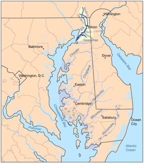
The Elk River is a tidal tributary of the Chesapeake Bay on the Eastern Shore of Maryland and on the northern edge of the Delmarva Peninsula. It is about 15 miles (24 km) long. As the most northeastern extension of the Chesapeake Bay estuary, it has served as one entrance to the Chesapeake & Delaware Canal since the 19th century. The canal and river now serve as one boundary of the Elk Neck Peninsula. The river flows through Cecil County, Maryland, with its watershed extending into New Castle County, Delaware and Chester County, Pennsylvania. Elkton, the county seat of Cecil County, is located at its head. Its total watershed area is 143 square miles (370 km2), with 21 square miles (54 km2) of open water, so its watershed is 15% open water. It is south and east of the North East River, and north of the Sassafras River.
Marshyhope Creek is a 37.0-mile-long (59.5 km) tributary of the Nanticoke River on the Delmarva Peninsula. It rises in Kent County, Delaware, and runs through Caroline County, Maryland, and Dorchester County, Maryland.

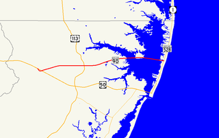
Sinepuxent Bay is an inland waterway which connects Chincoteague Bay to Isle of Wight Bay, and is connected to the Atlantic Ocean via the Ocean City Inlet. It separates Sinepuxent Neck, in Worcester County, Maryland from Assateague Island, and West Ocean City, Maryland from downtown Ocean City. Islands in the Sinepuxent Bay include Horn Island and Skimmer Island. It is crossed by the Harry W. Kelley Memorial Bridge on U.S. Route 50 and the Verrazano Bridge on Maryland Route 611. The bay is the location of the islands that compose the Sinepuxent Bay Wildlife Management Area. Historically the area was referred to by various names including Sinepuxent, Sene Puxon, Synepuxent, Cinnepuxon, et al.
Chuckatuck Creek is a 13.3-mile-long (21.4 km) tributary of the James River in the U.S. state of Virginia. The creek rises in Isle of Wight County and flows southeast to Chuckatuck in the city of Suffolk, where it turns northeast as it passes under State Route 10/State Route 32. Becoming tidal, the creek continues northeast to the mouth of Brewers Creek, where it broadens considerably and becomes the boundary between Isle of Wight County and the city of Suffolk. If proceeds under the Crittenden Bridge at Crittenden and reaches the James River at Batten Bay.

The Northeast River is a tributary of the Chesapeake Bay in Maryland. Entirely tidal, it extends for about 5.0 miles (8.0 km) from the town of North East southwest past Charlestown to the main body of Chesapeake Bay between Carpenter's Point and Red Point. The river is fed by North East Creek and its tributaries, which reach as far north as just east of Nottingham, Pennsylvania. The Northeast River is entirely within Cecil County, Maryland, though its watershed extends into Chester County, Pennsylvania. Its watershed area in MD is 63 square miles (160 km2), with 6% impervious surface in 1994. On the 1612 John Smith map, it was referred to as Gunter's Harbour.

Jacks Fork is one of two rivers in Missouri that are part of the Ozark National Scenic Riverways system.

Maryland Route 367 is a state highway in the U.S. state of Maryland. Known as Bishopville Road, the state highway runs 2.60 miles (4.18 km) from the county-maintained portion of Bishopville Road at Bishop east to the Delaware state line near Bishopville. MD 367 connects U.S. Route 113 with Bishopville and other small communities on the St. Martin Neck in northern Worcester County. The state highway was constructed between Bishop and Bishopville in two steps in the mid-1920s and early 1930s, respectively. The segment within Bishopville was constructed as part of an extended MD 368 in the mid-1910s. The portion from Bishopville to the Delaware state line was constructed in the mid-1930s as MD 568. All three state highways were reassigned to their present lengths in 1950.

Paint Branch is a 14.0-mile-long (22.5 km) stream that flows through Montgomery County and Prince George's County, Maryland. It is a tributary of the Northeast Branch, which flows to the Anacostia River, Potomac River and the Chesapeake Bay.
Nassawango Creek is a stream in the U.S. state of Maryland; it is the largest tributary of the Pocomoke River, located on the Delmarva Peninsula. Older variations on the same name include Nassanongo, Naseongo, Nassiongo, and Nassiungo, meaning "[ground] between [the streams]". Early English records have it as Askimenokonson Creek, after a Native settlement near its headwaters.
Isle of Wight Wildlife Management Area is a state wildlife management area (WMA) of Maryland located on the Isle of Wight, a small peninsula between the St. Martin's River and Isle of Wight Bay in Worcester County. Although called Isle of Wight, a small strip of marsh and road connects it with the mainland.
Tuckahoe Creek is a 21.5-mile-long (34.6 km) tributary of the Choptank River on Maryland's Eastern Shore. It is sometimes (erroneously) referred to as the Tuckahoe River. Upstream of Hillsboro, it forms the boundary between Caroline County and Queen Anne's County, passing through Tuckahoe State Park and dividing the small towns of Queen Anne and Hillsboro. Downstream of Hillsboro, it forms the boundary between Caroline County and Talbot County, before flowing into the Choptank.
Isle of Wight is an island in Worcester County, Maryland. The island is in Isle of Wight Bay at the mouth of St. Martin River just west of Ocean City on Fenwick Island in eastern Maryland. The Ocean City Expressway crosses the island between the mainland and Fenwick Island.
The West River is a 6-mile-long (9.7 km) tidal tributary of Chesapeake Bay in southern Anne Arundel County, Maryland. It is south of the Rhode River, which is one of its tributaries, and north of Herring Bay.
Manokin River is a river in Somerset County, Maryland, that flows into Tangier Sound, an arm of the Chesapeake Bay. The Manokin rises east of Princess Anne, Maryland, flows through the town, then widens into a tidal estuary. Tributaries along the river's 17-mile (27 km) length are Kings Creek, Back Creek, St. Peters Creek, Broad Creek, and Fishing Creek. During the colonial period, the Manokin was navigable as far as Princess Anne.
Dog and Bitch Island is an island in Worcester County, Maryland, in the United States. It is located within the Isle of Wight Bay. The island is small in size and marshy.