Related Research Articles

The Chesapeake Bay is the largest estuary in the United States. The Bay is located in the Mid-Atlantic region and is primarily separated from the Atlantic Ocean by the Delmarva Peninsula with its mouth of the Bay at the south end located between Cape Henry and Cape Charles. With its northern portion in Maryland and the southern part in Virginia, the Chesapeake Bay is a very important feature for the ecology and economy of those two states, as well as others surrounding within its watershed. More than 150 major rivers and streams flow into the Bay's 64,299-square-mile (166,534 km2) drainage basin, which covers parts of six states and all of District of Columbia.

Colonial Beach, Virginia (CBVA) is a river and beach town located in the northwestern part of Westmoreland County on Virginia's Northern Neck peninsula. It is bounded by the Potomac River, Monroe Bay and Monroe Creek. It is located 65 mi (105 km) from Washington, D.C.; 70 mi (110 km) from the state capital of Richmond; and 35 nautical miles from the Chesapeake Bay.

The Eastern Shore of Maryland is a part of the U.S. state of Maryland that lies mostly on the east side of the Chesapeake Bay. Nine counties are normally included in the region. The Eastern Shore is part of the larger Delmarva Peninsula that Maryland shares with Delaware and Virginia.

The Severn River is a tidal estuary 14 miles (23 km) long, located in Anne Arundel County in the U.S. state of Maryland, south of the Magothy River and north of the South River.

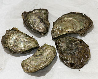
Oyster farming is an aquaculture practice in which oysters are bred and raised mainly for their pearls, shells and inner organ tissue, which is eaten. Oyster farming was practiced by the ancient Romans as early as the 1st century BC on the Italian peninsula and later in Britain for export to Rome. The French oyster industry has relied on aquacultured oysters since the late 18th century.
The Magothy River runs 12.1 miles (19.5 km) through Anne Arundel County in the U.S. state of Maryland. It is located south of the Patapsco River and north of the Severn River. There are two public park paddling access points, Beachwood Park on the north shore a half mile east of the Magothy Bridge Road bridge, and Spriggs Farm Park off Bayberry Drive, on the south shore two miles west of the Magothy's mouth. Both are Anne Arundel County parks.

The Chesapeake Bay Program is the regional partnership that directs and conducts the restoration of the Chesapeake Bay in the United States. As a partnership, the Chesapeake Bay Program brings together members of various state, federal, academic and local watershed organizations to build and adopt policies that support Chesapeake Bay restoration. By combining the resources and unique strengths of each individual organization, the Chesapeake Bay Program is able to follow a unified plan for restoration. The program office is located in Annapolis, Maryland.

Helen Delich Bentley Port of Baltimore is a shipping port along the tidal basins of the three branches of the Patapsco River in Baltimore, Maryland on the upper northwest shore of the Chesapeake Bay. It is the nation's largest port facilities for specialized cargo and passenger facilities. It is operated by the Maryland Port Administration (MPA), a unit of the Maryland Department of Transportation.
Barren Island is small, uninhabited landmass in the Chesapeake Bay, just off the coast of Dorchester County, Maryland. It is located at 38°20′4.13″N76°15′11.44″W. It is known to be a mute swan nesting ground.

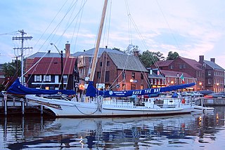
The Chesapeake Bay Maritime Museum is located in St. Michaels, Maryland, United States and is home to a collection of Chesapeake Bay artifacts, exhibitions, and vessels. This 18-acre (73,000 m2) interactive museum was founded in 1965 on Navy Point, once a site of seafood packing houses, docks, and work boats. Today, the museum houses the world's largest collection of Chesapeake Bay boats and provides interactive exhibits in and around the 35 buildings which dot the campus. The museum also offers year-round educational seminars and workshops.
Ostrea lurida, common name the Olympia oyster, after Olympia, Washington in the Puget Sound area, is a species of edible oyster, a marine bivalve mollusk in the family Ostreidae. This species occurs on the northern Pacific coast of North America. Over the years the role of this edible species of oyster has been partly displaced by the cultivation of non-native edible oyster species.

The Tred Avon River is a main tributary of the Choptank River in Talbot County on Maryland's Eastern Shore. The river is 17 miles (27 km) long.
The Stanley Norman is a Chesapeake Bay skipjack, built in 1902 by Otis Lloyd, Salisbury, Maryland. She is a 48-foot-3-inch-long (14.71 m) in Length overall with length on deck (LOD) OF 47.5-foot-long (14.5 m) two-sail bateau, or "V"-bottomed deadrise type of centerboard sloop. She has a beam of 16 feet (4.9 m), a depth of 4 feet (1.2 m) at the stern with the centerboard up, and a registered tonnage of 7 tons.
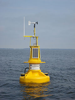
Chesapeake Bay Interpretive Buoy System (CBIBS) is a network of observational buoys that are deployed throughout the Chesapeake Bay to observe the estuary's changing conditions and to serve as way points along the Captain John Smith Chesapeake National Historic Trail. They are maintained by the United States National Oceanic and Atmospheric Administration (NOAA). These "smart buoys" observe and record meteorological, oceanographic and water quality data which can be obtained in real-time by using mobile apps or by visiting http://buoybay.noaa.gov/. CBIBS is an operational buoy system in the Chesapeake Bay dedicated to maintaining a broad range of measurements necessary to track Bay restoration progress.
Town Creek is a tributary of the Tred Avon River in Talbot County on Maryland's Eastern Shore.
Oyster reef restoration refers to the process of rebuilding or restoring of oyster reefs all over the globe. Over time, oysters have been negatively affected by environmental change, such as harmful fishing techniques, over harvesting, water pollution, and other factors. The results of these factors have been disease and ultimately, a large decline in the global population of oysters and the prevalence and sustainability of oyster reefs. Apart from the ecological importance of oyster reefs, oyster farming is an important industry, particularly in coastal areas. Both artificial materials and natural components have been used to rebuild the reefs in an attempt to regenerate the oyster population thus fostering the reformation of reefs.

Living shorelines are a relatively new approach for addressing shoreline erosion and protecting marsh areas. Unlike traditional structures such as bulkheads or seawalls that worsen erosion, living shorelines incorporate as many natural elements as possible which create more effective buffers in absorbing wave energy and protecting against shoreline erosion. The process of creating a living shoreline is referred to as soft engineering, which utilizes techniques that incorporate ecological principles in shoreline stabilization. The natural materials used in the construction of living shorelines create and maintain valuable habitats. Structural and organic materials commonly used in the construction of living shorelines include sand, wetland plants, sand fill, oyster reefs, submerged aquatic vegetation, stones and coir fiber logs.
The Tilghman Watermen's Museum records the maritime traditions of the people of Tilghman Island and the unique way of life of the watermen who lived on the island. It is located on Tilghman Island, Talbot County, Maryland, United States.
The Billion Oyster Project is a New York City-based nonprofit organization with the goal of restoring one billion live oysters to New York Harbor by 2035 through education initiatives. Because oysters are filter feeders, they serve as a natural water filter, with a number of beneficial effects for the ecosystem. The reefs they form increase habitat and subsequent marine biodiversity levels, and help protect the city's shorelines from storm surges.
The Suminoe oyster, is a species of true oyster which inhabits intertidal hard grounds and substrate, as well as muddy creeks of warm estuaries throughout the western Pacific. It is large and flat in appearance and almost identical in gross morphology to Crassostrea virginica.
References
- ↑ Harrison, Samuel Alexander (1915). History of Talbot County, Maryland, 1661-1861. Williams & Wilkins. p. 317.
- ↑ "Our Bay: Shore creek a test for oyster restoration". Capital Gazette: Environment. Archived from the original on June 5, 2012.
- ↑ "The Chesapeake Bay Oyster Expert: Oyster Recovery Partnership (ORP)". Oyster Recovery Partnership. Retrieved 2021-12-31.
- ↑ Harris Creek Restoration | The Nature Conservancy
- ↑ "Oyster Restoration Effort Planned on Eastern Shore". WBOC-TV 16 News. March 19, 2012.
- ↑ Jessica Wilde (February 17, 2013). "A 'Perfect Storm' for Oysters in Harris Creek". Potomac Local News Network.
- ↑ "DNR deploys new monitoring device in Harris Creek for oyster restoration efforts". Chesapeake360.com. July 18, 2012.
- ↑ Wheeler, Tim (December 13, 2013). "Florida shells to help revive MD's oysters". Los Angeles Times. Archived from the original on December 25, 2013. Retrieved 22 December 2013.