Prince George's County is located in the U.S. state of Maryland bordering the eastern portion of Washington, D.C. As of the 2020 U.S. census, the population was 967,201, making it the second-most populous county in Maryland, behind neighboring Montgomery County. The 2020 census counted an increase of nearly 104,000 in the previous ten years. Its county seat is Upper Marlboro. It is the largest and the second most affluent African American-majority county in the United States, with five of its communities identified in a 2015 top ten list.
Howard County is located in the U.S. state of Maryland. As of the 2020 census, the population was 334,529. Since there are no incorporated municipalities, there is no incorporated county seat either. Therefore, its county seat is the unincorporated community of Ellicott City. Howard County is included in the Baltimore-Columbia-Towson, MD Metropolitan Statistical Area, which is part of the larger Washington–Baltimore combined statistical area.

Brookeville is a town in Montgomery County, Maryland, located 20 km (12 mi) north of Washington, D.C., and 2 km (1.2 mi) north of Olney. Brookeville was settled by Quakers late in the 18th century and was formally incorporated as a town in 1808. Historically part of the local agricultural industry, Brookeville is now at the northern edge of the densely developed Washington suburbs. The population was 166 at the 2020 census.

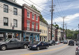
Laurel is a city in Maryland, United States, located midway between Washington, D.C. and Baltimore on the banks of the Patuxent River. While the city limits are entirely in northern Prince George's County, outlying developments extend into Anne Arundel, Montgomery and Howard counties. Founded as a mill town in the early 19th century, Laurel expanded local industry and was later able to become an early commuter town for Washington and Baltimore workers following the arrival of the Baltimore and Ohio Railroad in 1835. Largely residential today, the city maintains a historic district centered on its Main Street, highlighting its industrial past.

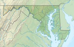
The Patuxent River is a tributary of the Chesapeake Bay in the state of Maryland. There are three main river drainages for central Maryland: the Potomac River to the west passing through Washington, D.C., the Patapsco River to the northeast passing through Baltimore, and the Patuxent River between the two. The 908-square-mile (2,352 km2) Patuxent watershed had a rapidly growing population of 590,769 in 2000. It is the largest and longest river entirely within Maryland, and its watershed is the largest completely within the state.

Maryland Route 198 is a state highway in the U.S. state of Maryland. The highway runs 14.14 miles (22.76 km) from MD 650 near Spencerville east to the entrance of Fort George G. Meade beyond its junction with MD 32. MD 198 connects Laurel in far northern Prince George's County with the northeastern Montgomery County communities of Spencerville and Burtonsville and Maryland City and Fort Meade in western Anne Arundel County. The highway is a four-to-six-lane divided highway between U.S. Route 29 in Burtonsville and the Baltimore–Washington Parkway in Maryland City.

The Washington Suburban Sanitary Commission is a bi-county political subdivision of the State of Maryland that provides safe drinking water and wastewater treatment for Montgomery and Prince George's Counties in Maryland except for a few cities in both counties that continue to operate their own water facilities.
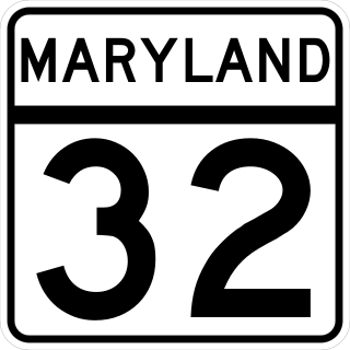
Maryland Route 32 (MD 32) is a state highway in the U.S. state of Maryland. The road runs 51.79 miles (83.35 km) from Interstate 97 (I-97) and MD 3 in Millersville west and north to Washington Road in Westminster. The 30 mile four- to six-lane freeway portion of MD 32 is the Patuxent Freeway between I-97 and I-70 in West Friendship. The freeway passes through Odenton and Fort Meade, the site of Fort George G. Meade and the National Security Agency (NSA), in western Anne Arundel County and along the southern part of Columbia in Howard County. Via I-97, MD 32 connects those communities with U.S. Route 50 (US 50)/US 301 in Annapolis. MD 32 also intersects the four primary highways connecting Baltimore and Washington: the Baltimore–Washington Parkway, US 1, I-95, and US 29. MD 32's north–south section, Sykesville Road, connects West Friendship and Westminster by way of Sykesville and Eldersburg in southern Carroll County.

U.S. Route 1 (US 1) is the easternmost and longest of the major north–south routes of the older 1920s era United States Numbered Highway System, running from Key West, Florida, to Fort Kent, Maine. In the U.S. state of Maryland, it runs 81 miles (130 km) from the Washington D.C. line to the Pennsylvania state line near the town of Rising Sun.

Maryland Route 216 is a state highway in the U.S. state of Maryland. Known for most of its length as Scaggsville Road, the highway runs 8.73 miles (14.05 km) from MD 108 at Highland east to MD 198 in Laurel. MD 216 connects Highland, Fulton, Scaggsville, and North Laurel in southern Howard County with Laurel in far northern Prince George's County. The highway connects those communities with Interstate 95 (I-95) and U.S. Route 29.

U.S. Route 29 is a north–south United States highway that runs for 1,036 miles (1,667 km) from the western suburbs of Baltimore, Maryland, to Pensacola, Florida. In the U.S. state of Maryland, US 29 is a major highway that emerges from Washington, D.C., and runs north into eastern Montgomery County, stretching over 25.859 miles (41.62 km) through the state and terminating at Maryland Route 99 outside of Ellicott City. It serves the cities of Columbia and Ellicott City and provides the westernmost north–south route between Washington, D.C., and Baltimore.
Scaggsville is an unincorporated community and census-designated place in Howard County, Maryland, United States. It is situated near the southeastern tip of Howard County, between Laurel and Fulton. As of the 2010 census it had a population of 24,333. The town mainly consists of residences, with some commercial establishments. Scaggsville generally falls within ZIP code 20723, assigned to Laurel, though the town formerly had its own post office.
Fulton is a census-designated place located in southern Howard County, Maryland, United States. As of the 2010 census it had a population of 2,049.
Hawlings River is a 12.9-mile-long (20.8 km) tributary of the Patuxent River in Montgomery County, Maryland. The watershed covers an area of about 28 square miles (73 km2). The waterway was originally called Holland's River. The headwaters of the river originate in the area north of Laytonsville, and the river flows southeast, entering the Patuxent about 1.5 miles (2.4 km) below the Triadelphia Reservoir. Portions of Hawlings River flow through Rachel Carson Conservation Park and Hawlings River Stream Valley Park. Tributaries of the Hawlings River include Mount Zion Tributary, Reddy Branch, Olney Mill Tributary, Gregg Tributary, and James Creek. The river and its tributaries total about 98 miles (158 km) of streams.

Little Seneca Lake is a reservoir located near the Boyds community in Montgomery County, Maryland.
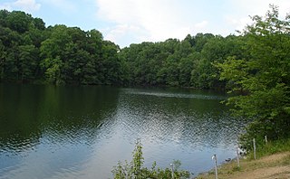
Triadelphia Reservoir is located on the Patuxent River, in Howard County and Montgomery County, Maryland near the town of Brookeville.

Whiskey Bottom Road is a historic road north of Laurel, Maryland that traverses Anne Arundel and Howard Counties in an area that was first settled by English colonists in the mid-1600s. The road was named in the 1880s in association with one of its residents delivering whiskey after a prohibition vote. With increased residential development after World War II, it was designated a collector road in the 1960s; a community center and park are among the most recent roadside developments.
Burnt Mills is an census designated place in Montgomery County, Maryland, United States. Per the 2020 Census, the population was 3,592.