Related Research Articles

The Delmarva Peninsula, or simply Delmarva, is a large peninsula and proposed state on the East Coast of the United States, occupied by the vast majority of the state of Delaware and parts of the Eastern Shore regions of Maryland and Virginia. The peninsula is 170 miles (274 km) long. In width, it ranges from 70 miles (113 km) near its center, to 12 miles (19 km) at the isthmus on its northern edge, to less near its southern tip of Cape Charles. It is bordered by the Chesapeake Bay on the west, Pocomoke Sound on the southwest, and the Delaware River, Delaware Bay, and the Atlantic Ocean on the east.
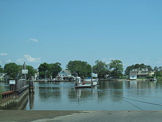
The Wicomico River is a 24.4-mile-long (39.3 km) tributary of the Chesapeake Bay on the eastern shore of Maryland. It drains an area of low marshlands and farming country in the middle Delmarva Peninsula.

The Conestoga River, also referred to as Conestoga Creek, is a 61.6-mile-long (99.1 km) tributary of the Susquehanna River flowing through the center of Lancaster County, Pennsylvania, United States.

Harveys Creek is a tributary of the Susquehanna River in Luzerne County, Pennsylvania, in the United States. It is approximately 14.5 miles (23.3 km) long and flows through Harveys Lake, Lake Township, Lehman Township, Jackson Township, and Plymouth Township. The creek's watershed has an area of 46.3 square miles (120 km2). The creek has four named tributaries, which are known as Bear Hollow Creek, Paint Spring Run, Pikes Creek, and East Fork Harveys Creek. The watershed is designated as a High-Quality Coldwater Fishery and a Migratory Fishery above Pikes Creek and as a Coldwater Fishery and a Migratory Fishery below it. The creek's source is Harveys Lake, the largest natural lake in Pennsylvania.

Chillisquaque Creek is a tributary of the West Branch Susquehanna River in Montour County and Northumberland County, in Pennsylvania, in the United States. It is approximately 20.2 miles (32.5 km) long and flows through Derry Township, Washingtonville, and Liberty Township in Montour County and East Chillisquaque Township and West Chillisquaque Township in Northumberland County. The watershed of the creek has an area of 112 square miles (290 km2). Agricultural impacts have caused most of the streams in the watershed of the creek to be impaired. Causes of impairment include sedimentation/siltation and habitat alteration. The average annual discharge of the creek between 1980 and 2014 ranged from 48.2 to 146.0 cubic feet per second. Its watershed mainly consists of rolling agricultural land. The creek's channel flows through rock formations consisting of sandstone and shale. It is a warmwater stream.

Conewago Creek is an 80.2-mile-long (129.1 km) tributary of the Susquehanna River in Adams and York counties in Pennsylvania in the United States, with its watershed also draining a small portion of Carroll County, Maryland. The source is at an elevation of 1,440 feet (440 m), east of Caledonia State Park, in Franklin Township in Adams County. The mouth is the confluence with the Susquehanna River at York Haven in York County at an elevation of 259 feet (79 m).
Codorus Creek is a 42.4-mile-long (68.2 km) tributary of the Susquehanna River in York County, Pennsylvania in the United States.

The Great Cypress Swamp, is a forested freshwater swamp located on the Delmarva Peninsula in south Delaware and southeastern Maryland. As of 2000, it is the largest contiguous forest on the Delmarva Peninsula.
Pocomoke State Forest is a state forest of Maryland that lies on both banks of the Pocomoke River in Worcester County. The portion north of the Pocomoke lies between Dividing and Nassawango Creeks. The Pocomoke River Wildlife Management Area borders the southern portion of the forest.
The Assateague were an Algonquian people speaking the Nanticoke language who historically lived on the Atlantic coast side of the Delmarva Peninsula.
Drury Run is a tributary of the West Branch Susquehanna River in Clinton County, Pennsylvania, in the United States. It is 7.71 miles (12.41 km) long and its watershed is 11.5 square miles in area, most of which is forest. The stream's tributaries are affected by acid mine drainage, as are the lower reaches of the stream itself. It begins in Tamarack Swamp and flows through Leidy Township, Noyes Township, and Renovo. Brook trout, brown trout, creek chub, and eastern blacknose dace all inhabit the stream.

Hunlock Creek is a tributary of the Susquehanna River in Luzerne County, Pennsylvania, in the United States. It is approximately 7.8 miles (12.6 km) long and flows through Lehman Township and Hunlock Township. The watershed of the creek has an area of 32.5 square miles (84 km2) and is situated in northwestern Luzerne County. It has one named tributary, which is known as Roaring Brook, and a number of unnamed and unofficially named tributaries, such as "West Branch Hunlock Creek".

Roaring Brook is a tributary of the Lackawanna River in Lackawanna County, Pennsylvania, in the United States. It is approximately 21 miles (34 km) long and flows through Covington Township, Madison Township, Moscow, Roaring Brook Township, Elmhurst Township, Dunmore, and Scranton. The watershed of the stream has an area of 56.3 square miles (146 km2). Its named tributaries include Little Roaring Brook, Rock Bottom Creek, White Oak Run, Van Brunt Creek, Bear Brook, and East Branch Roaring Brook. It has a high level of water quality for much of its length. However, it is affected by abandoned mining land, stormwater, and other impacts in its lower reaches. Reservoirs in the watershed include the Hollister Reservoir, the Elmhurst Reservoir, and others. The stream also flows through the Nay Aug Gorge and passes over the Nay Aug Falls, which are on the National Register of Geologic Landmarks. It flows through a concrete channel in its lower reaches. The topography of the watershed contains rolling hills in its upper reaches and the mountainous land of the Moosic Mountains in its lower reaches.
Aylesworth Creek is a tributary of the Lackawanna River in Lackawanna County, Pennsylvania, in the United States. It is approximately 4.9 miles (7.9 km) long and flows through Carbondale Township and the boroughs of Mayfield and Archbald. The watershed of the creek has an area of 6.73 square miles (17.4 km2). Part of the creek is impaired by abandoned mine drainage and/or resource extraction. The creek tends to be slightly acidic, but its iron, manganese, and aluminum concentrations do not need reduction to meet its total maximum daily load requirements. Its watershed is in the Appalachian Mountain section of the ridge and valley physiographic province. The headwaters of the creek are in the Moosic Mountains. The rock formations in the watershed mainly consist of interbedded sedimentary rock and sandstone.

Furnace Run is a tributary of Shamokin Creek in Northumberland County, Pennsylvania, in the United States. It is approximately 1.0 mile (1.6 km) long and flows through Coal Township and Shamokin. The watershed of the stream has an area of 1.61 square miles (4.2 km2). It is impaired by sedimentation and siltation from urban runoff and storm sewers, but is not impacted by mine drainage. Reaches of the stream have been entirely enclosed. Furnace Run is named after a furnace that was built in the area in 1825. The stream is designated as a Coldwater Fishery and a Migratory Fishery.
Ackerly Creek is a tributary of South Branch Tunkhannock Creek in Lackawanna County, Pennsylvania, in the United States. It is approximately 8.7 miles (14.0 km) long and flows through South Abington Township, Waverly Township, Glenburn Township, Dalton, and La Plume Township. The creek has several unnamed tributaries and drains an area of nearly 18 square miles (47 km2). Ackerly Creek is not designated as an impaired waterbody, but it is impacted by some water quality problems. In one reach, the creek flows through Rabbit Hollow, which is set aside as a preserve. The creek experiences some erosion due to its banks being managed and straightened where it flows alongside US Route 6 and US Route 11.
The Delmarva Central Railroad is an American short-line railroad owned by Carload Express that operates 188 miles (303 km) of track on the Delmarva Peninsula in the states of Delaware, Maryland, and Virginia. The railroad operates lines from Porter, Delaware to Hallwood, Virginia and from Harrington, Delaware to Frankford, Delaware along with several smaller branches. The DCR interchanges with the Norfolk Southern Railway and the Maryland and Delaware Railroad. The railroad was created in 2016 to take over the Norfolk Southern Railway lines on the Delmarva Peninsula. The DCR expanded by taking over part of the Bay Coast Railroad in 2018 and the Delaware Coast Line Railroad in 2019.
Ilia Fehrer was an environmentalist and member of the Maryland Women's Hall of Fame most widely known for fighting to preserve Assateague Island, Chincoteague Bay, and other Chesapeake Bay coastal regions from destructive urban development.
References
- ↑ Runkle, Stephen A. Native American Waterbody and Place Names within the Susquehanna River Basin and Surrounding Subbasins Publication 229. Susquehanna River Basin Commission, September 2003.
- ↑ Quesada-Embid, Mercedes (2004), "Five Hundred Years on Five Thousand Acres: Human Attitudes and Land Use at Nassawango Creek", Edward H. Nabb Research Center for Delmarva History and Culture, Native Americans of the Delmarva Peninsula, Salisbury, MD, archived from the original on 2012-12-14, retrieved June 21, 2020
{{citation}}: CS1 maint: unfit URL (link) - ↑ U.S. Geological Survey. National Hydrography Dataset high-resolution flowline data. The National Map, accessed April 1, 2011
- ↑ "Nassawango Creek Preserve". The Nature Conservancy . Archived from the original on 2008-10-02. Retrieved June 21, 2020.