Susquehanna River Basin Commission

Last updated
Susquehanna watershed Susquehanna River watershed.png
Susquehanna watershed

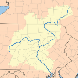
The Susquehanna River Basin Commission (SRBC) is a federal-interstate compact commission created by the Susquehanna River Basin Compact (Pub. L. 91-575) between three U.S. states: (Pennsylvania, New York, and Maryland), and the federal government, and signed into law by President Richard Nixon on Christmas Eve 1970 to be effective 30 days later on January 23, 1971. [1]

Contents

The Compact

In the late 1960s, a broad group of concerned citizens saw the need for a federal-interstate coordinating agency to lead the conservation, development, and administration of the Basin's resources that would preserve and enhance its value as a scenic and recreational asset for the people who live in the Basin. The need to coordinate these efforts, along with those of three states and the agencies of the federal government, led to the drafting of the Susquehanna River Basin Compact, which was signed into law on December 24, 1970. The Compact, as adopted by the Congress of the United States, and the legislatures of New York State, Pennsylvania, and Maryland, provides the mechanism to guide water resource management of the Susquehanna River Basin.

Membership

State membership on the Commission includes the governors of the three participating states or their designees. Under Pub. L. 110–114, the federal member is ex officio the Commander, North Atlantic Division, U.S. Army Corps of Engineers. [2] The members appoint alternate members to serve in their place. As of August 2018, Major General Jeffrey L. Milhorn is the federal member of the commission. Secretary Ben Grumbles is the member from Maryland and Basil Seggos is the member from New York. Secretary Patrick McDonnell is the member from the Commonwealth of Pennsylvania.

Major General Jeffrey L. Milhorn also serves as the United States Member of the Delaware River Basin Commission under the authority of Pub. L. 110–114.

The commission's appointed members do periodically change. Here is the most current member list.

Purpose and Activities

The purpose of the SRBC is to manage the water resources of the Susquehanna River under comprehensive planning principles through its own programs and by coordinating the efforts of the three states and the federal government. These program efforts include implementation of structural and non-structural flood mitigation projects, regulation of water withdrawals and consumptive use, allocation of water resources among the member states, restoration and preservation of fisheries and wetlands, protection of future water supply (including availability of flows into the Chesapeake Bay), and protection of water quality. [3]

Commission staff develops and implements the programs as directed by the commissioners and as found in Commission's comprehensive plan. The six priority management areas of the Comprehensive Plan are listed below, along with desired results.

Sustainable Water Development: To regulate and plan for water resources development in a manner that maintains economic viability, protects instream users, and ensures ecological diversity; and meets immediate and future needs of the people of the basin for domestic, municipal, commercial, agricultural and industrial water supply and recreational activities.

Water Quality: To support the existing and designated uses of all water bodies by achieving water quality that meets or exceeds standards.

Flooding: To prevent loss of life and significantly reduce future damages from floods within the Basin through an integrated system of structural and nonstructural flood damage reduction measures.

Ecosystems: To achieve healthy ecosystems that provide groundwater and surface water of sufficient quality and in adequate supply to support abundant and diverse populations of aquatic, riparian, and terrestrial organisms, as well as human use.

Chesapeake Bay: To manage the water resources of the Susquehanna River Basin to assist in restoring and maintaining the Chesapeake Bay so it meets or exceeds applicable water quality standards and supports healthy populations of living resources, including oysters, crabs, fish, waterfowl, shore birds, and underwater grasses.

Coordination, Cooperation and Public Information: To maximize available human resources and achieve common and complementary management objectives by the commission, its member jurisdictions and others; to promote the planning and management of the basin's water resources in the most efficient manner possible; to inform the public on the commission's water management responsibilities; and to enhance the public's access to Commission information and in commenting on Commission activities.

Program Areas

The Commission completes much of its work through four program areas. These programs include:

Project Review – the permitting arm of the commission's regulatory program, the Project Review team receives and reviews applications for water withdrawals and consumptive water use, makes recommendations to the commissioners for actions on those applications, and helps to develop key standards guiding how, when and where the commission's policies and regulations are exercised.

Compliance and Enforcement – the enforcement arm of the commission's regulatory program, the Compliance Program works to ensure that water related projects have the appropriate approvals and operate within the constraints of those approvals. Site inspections, quarterly reporting requirements, and an extensive project database are some of the essential tools used by the program.

Monitoring & Protection - Monitoring and Protection scientists collect data to better understand the interactions of biological, chemical, and physical traits of streams throughout the Basin. These activities include water quality monitoring/sampling for macroinvertebrates & fish, stormwater, nutrient and sediment loadings, and abandoned mine drainage. Key protection efforts include operation of systems that provide real-time monitoring in sensitive watersheds and in the vicinity of drinking water supplies, establishing Total Maximum Daily Load criteria, assessing risks to drinking water sources, and characterizing the cause and extent of impairment to Basin waterways.

Planning & Operations – Planning and Operations provides technical support to the other programs and is tasked with assessing the nature and quantity of water use in the Basin. The Planning and Operations team also leads coordination efforts to help ensure that Basin agencies and residents are prepared to withstand and react to flooding and drought conditions.

Controversy

In 2012 the Commission attracted protests by approving the extraction of water for use in fracking, an activity whose opponents claim causes earthquakes, creates ground-water pollution and contributes to global warming. [4]

This water extraction involved the sale of a mobile home park by the owner to Aqua America who had gotten permission from the commission to withdraw up to 3 million gallons of water per day from the Susquehanna at that site. Aqua America then evicted the occupants so as to build a pumping station on the site, attracting further protests from the residents of the site and their supporters. [5]

The sale of the property, not the Commission approval, triggered the eviction due to a local ordinance about operating the mobile home park in a floodplain. http://articles.philly.com/2012-04-18/business/31361933_1_fracking-trailer-park-anti-drilling

See also

Related Research Articles

<span class="mw-page-title-main">Chesapeake Bay</span> Estuary in the U.S. states of Maryland and Virginia

The Chesapeake Bay is the largest estuary in the United States. The Bay is located in the Mid-Atlantic region and is primarily separated from the Atlantic Ocean by the Delmarva Peninsula, including parts of the Eastern Shore of Maryland, the Eastern Shore of Virginia, and the state of Delaware. The mouth of the Bay at its southern point is located between Cape Henry and Cape Charles. With its northern portion in Maryland and the southern part in Virginia, the Chesapeake Bay is a very important feature for the ecology and economy of those two states, as well as others surrounding within its watershed. More than 150 major rivers and streams flow into the Bay's 64,299-square-mile (166,534 km2) drainage basin, which covers parts of six states, New York, Pennsylvania, Delaware, Maryland, Virginia, and West Virginia, and all of Washington, D.C.

In the United States, an interstate compact is a pact or agreement between two or more states, or between states and any foreign government. The Compact Clause of the United States Constitution provides that "No State shall, without the Consent of Congress,... enter into any Agreement or Compact with another State, or with a foreign Power,..."

<span class="mw-page-title-main">Mattawoman Creek</span> Coastal plain tributary in Maryland, United States

Mattawoman Creek is a 30.0-mile-long (48.3 km) coastal-plain tributary to the tidal Potomac River with a mouth at Indian Head, Maryland, 20 miles (32 km) downstream of Washington, D.C. It comprises a 23-mile (37 km) river flowing through Prince George's and Charles counties and a 7-mile (11 km) tidal-freshwater estuary in Charles County. About three-fourths of its 94-square-mile (240 km2) watershed lies in Charles County, with the remainder in Prince George's County immediately to the north.

<span class="mw-page-title-main">Texas Commission on Environmental Quality</span> Environmental agency of the state of Texas

The Texas Commission on Environmental Quality (TCEQ) is the environmental agency for the state of Texas. The commission's headquarters are located at 12100 Park 35 Circle in Austin. The fourth-largest environmental agency in the United States, it employs about 2,780 employees, has 16 regional offices, and has a $420 million operating budget for the 2016 fiscal year.

<span class="mw-page-title-main">Chesapeake Bay Program</span> Organization implementing a plan to remediate ecosystem damage

The Chesapeake Bay Program is the regional partnership that directs and conducts the restoration of the Chesapeake Bay in the United States. As a partnership, the Chesapeake Bay Program brings together members of various state, federal, academic and local watershed organizations to build and adopt policies that support Chesapeake Bay restoration. By combining the resources and unique strengths of each individual organization, the Chesapeake Bay Program is able to follow a unified plan for restoration. The program office is located in Annapolis, Maryland.

<span class="mw-page-title-main">Conewago Creek (west)</span> West tributary of the Susquehanna River in Pennsylvania, United States

Conewago Creek is an 80.2-mile-long (129.1 km) tributary of the Susquehanna River in Adams and York counties in Pennsylvania in the United States, with its watershed also draining a small portion of Carroll County, Maryland. The source is at an elevation of 1,440 feet (440 m), east of Caledonia State Park, in Franklin Township in Adams County. The mouth is the confluence with the Susquehanna River at York Haven in York County at an elevation of 259 feet (79 m).

The Maryland Department of Natural Resources (DNR) is a government agency in the state of Maryland charged with maintaining natural resources including state parks, public lands, state forests, state waterways, wildlife, and recreation areas. Its headquarters are in Annapolis.

The Water Resources Development Act of 1996 is part of Pub. L.Tooltip Public Law  104–303 (text)(PDF), was enacted by Congress of the United States on October 12, 1996. Most of the provisions of WRDA 1996 are administered by the United States Army Corps of Engineers.

Water Resources Development Act of 1988, Pub. L.Tooltip Public Law  100–676, is a public law passed by Congress on November 17, 1988 concerning water resources in the United States in the areas of flood control, navigation, dredging, environment, recreation, water supply, beach nourishment and erosion.

The Water Resources Development Act of 1992, Pub. L.Tooltip Public Law  102–580, was enacted by Congress of the United States on October 31, 1992. Most of the provisions of WRDA 1992 are administered by the United States Army Corps of Engineers.

The Water Resources Development Act of 1999, Pub. L.Tooltip Public Law  106–53 (text)(PDF), was enacted by Congress of the United States on August 17, 1999. Most of the provisions of WRDA 1999 are administered by the United States Army Corps of Engineers.

The Water Resources Development Act of 2000, Pub. L.Tooltip Public Law  106–541 (text)(PDF), was enacted by Congress of the United States on December 11, 2000. Most of the provisions of WRDA 2000 are administered by the United States Army Corps of Engineers.

<span class="mw-page-title-main">Oklahoma Water Resources Board</span>

The Oklahoma Water Resources Board (OWRB) is an agency in the government of Oklahoma under the Governor of Oklahoma. OWRB is responsible for managing and protection the water resources of Oklahoma as well as for planning for the state's long-range water needs. The Board is composed of nine members appointed by the Governor with the consent of the Oklahoma Senate. The Board, in turn, appoints an Executive Director to administer the agency.

<span class="mw-page-title-main">Delaware River Basin Commission</span>

The Delaware River Basin Commission (DRBC) is a United States government agency created in 1961 by an interstate compact, signed into law by President John F. Kennedy, between four states (Pennsylvania, Delaware, New Jersey, and New York).

<span class="mw-page-title-main">Interstate Commission on the Potomac River Basin</span>

The Interstate Commission on the Potomac River Basin (ICPRB) is an agency composed of commissioners representing the federal government, the states of Maryland, Pennsylvania, Virginia, West Virginia, and the District of Columbia. The ICPRB mission is to enhance, protect, and conserve the water and associated land resources of the Potomac River basin and its tributaries through regional and interstate cooperation.

<span class="mw-page-title-main">Red River Compact Commission</span>

The Red River Compact was signed by the states of Arkansas, Louisiana, Oklahoma and Texas to avoid disputes over the waters of the Red River in 1978, although Congress had authorized the compact in 1955. The Red River Compact Commission has nine commissioners, two from each member state and one federal representative appointed by the President of the United States.

The Colorado Water Conservation Board (CWCB) operates as a division of the Colorado Department of Natural Resources. The Colorado legislature founded the Colorado Water Conservation Board (CWCB) through the passage of House Bill no. 6 in 1937 for the "purpose of aiding in the protection and development of the waters of the state". The bill decreed that the agency would be run by twelve directors, who convened for the first time on July 13, 1937.

<span class="mw-page-title-main">Union Mills Reservoir</span> Proposed, unfunded, unbuilt reservoir near Union Mills, Carroll County, Maryland, USA

A proposed Union Mills Reservoir represents a half century of efforts by the Commissioners of the Carroll County, Maryland, to build variations on a "dam" or "reservoir" near Union Mills, Maryland, on the Big Pipe Creek, defeated by a petition led by the Carroll County Taxpayers' Committee in the 1970s. The plan may be alive among some county officials but may also be postponed "indefinitely." Land threatened by the reservoir includes the Whittaker Chambers Farm, also known as the Pipe Creek Farm, a National Historic Landmark as well as protected under the Maryland Agricultural Land Preservation Foundation (MALPF).

References

  1. Each of the three participating states had already enacted the compact prior to its approval by the U.S. Congress and President Nixon, thus making it a solemn agreement among the parties to jointly exercise their sovereign powers in the management of the basin's water resources. The Commission is neither a federal or state agency, but rather is collectively the agency of all four of its member jurisdictions.Full text of the Susquehanna River Basin Compact
  2. "SRBC Commissioners". SRBC Official Website. Susquehanna River Basin Commission. 2009-06-10. Archived from the original on June 20, 2009. Retrieved 2009-06-10.
  3. Overview of the SRBC
  4. "SRBC approves water withdrawals for Marcellus drilling over chants from protesters". Pennlive. 2012-03-15. Retrieved 11 December 2012.
  5. "32-unit village no more". Williamsport Sun-Gazette. Retrieved 11 December 2012.