Interstate Commission on the Potomac River Basin

Last updated
Member states of the commission Interstate Commission on the Potomac River Basin members map.svg
Member states of the commission
The Potomac basin within the Chesapeake Bay watershed. ChesBay Basins-e1531252370325.jpg
The Potomac basin within the Chesapeake Bay watershed.

The Interstate Commission on the Potomac River Basin (ICPRB) is an agency composed of commissioners representing the federal government, the states of Maryland, Pennsylvania, Virginia, West Virginia, and the District of Columbia. The ICPRB mission is to enhance, protect, and conserve the water and associated land resources of the Potomac River basin and its tributaries through regional and interstate cooperation.

Contents

It was one of the first organizations with a congressional mandate to consider water resources on a watershed basis, rather than along political boundaries. [1] [2]

Authority

The Commission was created by an act of the United States Congress in 1940. [3] Congress amended the law in 1970, creating an interstate compact. [4]

Mission

ICPRB accomplishes its mission through a variety of actions to conduct, coordinate, and cooperate in studies and programs in the areas of water quality, water supply, living resources, and land resources. The Section for Cooperative Water Supply Operations on the Potomac River (CO-OP), a special section of the Commission, was created as a technical operations center for management and coordination among the regional utilities to avoid water supply shortages in the Washington metropolitan area during droughts.

Commissioners

The ICPRB Commissioners represent the commonwealths of Pennsylvania and Virginia, the states of Maryland and West Virginia, the District of Columbia, and the federal government. These individuals, appointed by their respective jurisdictions, set policy and provide guidance for the Commission, as an interstate compact agency.

Focus areas

Potomac River watershed Potomacwatershedmap.png
Potomac River watershed

Complementing the commissioners is a professional staff that has gained a strong reputation for delivery of sound science and analysis that arms decision-makers at various government levels with the facts and technical data to resolve issues concerning the watershed. The staff efforts focus on four primary areas of involvement:

Drinking water and water resources

The drinking water and water resources knowledge of the staff is used to coordinate the water supply withdrawals of the three major metropolitan area water utilities that rely on Potomac River water for nearly 500 million US gallons (1.9 gigalitres) per day to meet the thirst of the capital region. Throughout the basin, project expertise includes:

Water quality

Water quality issues addressed by Commission staff include supporting highly complex studies and projects that reap benefits both for the Potomac basin and for the Chesapeake Bay drainage, of which the basin comprises a major part. Project expertise includes:

Aquatic life

Staff in the aquatic life section of ICPRB work to evaluate and report on biological communities and how they respond to stream, river and estuarine conditions. Staff carefully measure and analyze aquatic life data in the Potomac basin and make management recommendations based on sound scientific data. Working collaboratively with other organizations, staff develop ecosystem indicators and analysis that is consistent basin-wide. Projects include:

Communication and education

The agency’s technical expertise is magnified by a communications program that extends the impacts and results of ICPRB’s projects to the region’s public. Work in protecting and improving the region’s resources can be effective only when the public is educated about the reasons for those actions and their role in the preservation of those resources. To that end, the Commission:

Cooperation and partnerships

The ICPRB works with numerous partners throughout the basin using cooperative skills for encouraging multiple jurisdictions to coordinate actions on water resource issues. This brings to the watershed needed action to address the basin’s major challenges, including water quality impairments, water supply, flooding, groundwater use, and nonpoint source pollution. The Commission can complete a range of surveys and assessments designed to increase the knowledge of the ecosystem that allows for more efficient resources management.

Regional facilitation

With the mainstem of the Potomac River forming interstate boundaries, a cooperative, non-regulatory regional organization is well-suited to facilitate solutions. In a basin of nearly 15,000 square miles (39,000 km2), including five principal political jurisdictions and more than five-million residents relying on its water for domestic, industrial and agricultural water supply purposes, a technically skilled agency must assist the multiple interests in solving water resources problems. With more than one-million acres of federally owned or managed land in the basin, the federal government has an interest in the waters of the basin. An agency that provides for coordinated state and federal water resources management actions can accomplish this if properly supported. Such an agency exists in the Interstate Commission on the Potomac River Basin.

Timeline of accomplishments

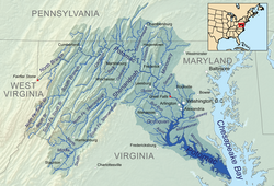
1940s - The Commission's first (1943) report on the condition of Potomac basin waters precipitates adoption of a pollution abatement program (1945), an intensive survey of industrial pollution (1946), and definition of a set of "Minimum Water Quality Criteria" (1946) by which Potomac streams and waterways may be judged suitable or unsuitable for several principal water uses. Concurrent to Congress enacting the first Federal Water Pollution Control Act (1948), ICPRB initiates a continuous water-quality sampling program in the basin. By 1949, ICPRB is given credit for coordination with local authorities to "radically" improve conditions on the Potomac's Shenandoah River tributary, recently referred to as a "biological desert" due to pollution from industrial waste.

1950s - ICPRB issues a major report describing the polluted Washington area Potomac and publishes the results of a study it sponsored on North Branch industrial wastes (1954). Under the auspices of the ICPRB, a group of citizens organizes the Citizens Council for a Clean Potomac (1956). As the U.S. Public Health Service declares the Potomac River unsafe for swimming, ICPRB estimates that on the average, 60 million cubic feet of sediment is deposited annually within the metropolitan Washington reach of the Potomac estuary (1957). Chairman Harold A. Kemp indicates Potomac River pollution has reached a "critical condition" with urgent need for additional sewage treatment facilities. [5] By 1958, ICPRB is gathering and tabulating information from about 85 stream sampling stations operated by cooperating agencies, municipalities and industries. The following year, ICPRB publishes its first "Potomac River Water Quality Network," holds a "first-of-its-kind" silt control conference and sponsors a study of sediment sources in the basin with the U.S. Geological Survey.

1960s - In 1963, ICPRB issues two reports on sediment sources and an urban sediment control program.

1970s - ICPRB's Compact is amended in 1970, extending its authority to include water supply and water-related land use. In 1975, an ICPRB conference focuses on rising dollar and energy costs associated with Washington, D.C. metro area sewage treatment.

1980s - ICPRB initiates regional discussion of the problem posed by invasive aquatic weed, hydrilla (1983). After Maryland (1985) and the District of Columbia (1986) initiate a phosphate detergent bans, ICPRB recommends (1987) expanding such bans basin-wide.

1990s - Maryland, West Virginia and ICPRB sign (1993) cooperative agreement on program to restore water quality to the North Branch. [6]

2000s– In 2001, the ICPRB combined decades of data into a consistent and usable format for researchers and those working on the watershed in the Tidal Potomac Integrative Analysis Project. In 2002, ICPRB's successful American Shad Restoration Project is completed, restoring the population of this historically significant fish that once flowed freely in the Potomac but had been decimated by pollution, overfishing, and blockage over the past century. In 2004, along with other partners in the basin, the Commission organizes and leads the formation of a voluntary partnership between water utilities and state and federal agencies known as the Potomac River Basin Drinking Water Source Protection Partnership which will focus on protecting the water quality of the river as the source of drinking water for millions of people that live in the basin. ICPRB developed an index of stream health known as Chessie BIBI in 2008. It is calculated from stream macroinvertebrate samples collected and counted by state, federal, and local agencies and other groups.

2010s - In 2011, scientists at ICPRB conduct a survey of freshwater mussels in the mainstem of the River. These sensitive creatures are good indicators of a healthy waterway. Having baseline information can help determine the future shifts in water quality. The Potomac River Basin Comprehensive Water Resources Plan is adopted in 2018. The plan describes a shared vision for the basin, identifies water resources issues of interstate and/or basin wide significance, and recommends actions for achieving the shared vision. [7]

See also

Related Research Articles

<span class="mw-page-title-main">Potomac River</span> River in the Mid-Atlantic United States

The Potomac River is a major river in the Mid-Atlantic region of the United States that flows from the Potomac Highlands in West Virginia to the Chesapeake Bay in Maryland. It is 405 miles (652 km) long, with a drainage area of 14,700 square miles (38,000 km2), and is the fourth-largest river along the East Coast of the United States and the 21st-largest in the United States. More than 5 million people live within its watershed.

<span class="mw-page-title-main">Anacostia River</span> River in Maryland and the District of Columbia, United States

The Anacostia River is a river in the Mid Atlantic region of the United States. It flows from Prince George's County in Maryland into Washington, D.C., where it joins with the Washington Channel and ultimately empties into the Potomac River at Buzzard Point. It is about 8.7 miles (14.0 km) long. The name "Anacostia" derives from the area's early history as Nacotchtank, a settlement of Necostan or Anacostan Native Americans on the banks of the Anacostia River.

Natural Resources Conservation Service (NRCS), formerly known as the Soil Conservation Service (SCS), is an agency of the United States Department of Agriculture (USDA) that provides technical assistance to farmers and other private landowners and managers.

<span class="mw-page-title-main">Monocacy River</span> River in Maryland, United States

The Monocacy River is a free-flowing left tributary to the Potomac River, which empties into the Atlantic Ocean via the Chesapeake Bay. The river is 58.5 miles (94.1 km) long, with a drainage area of about 970 square miles (2,500 km2). It is the largest Maryland tributary to the Potomac.

<span class="mw-page-title-main">Mattawoman Creek</span> Coastal plain tributary in Maryland, United States

Mattawoman Creek is a 30.0-mile-long (48.3 km) coastal-plain tributary to the tidal Potomac River with a mouth at Indian Head, Maryland, 20 miles (32 km) downstream of Washington, D.C. It comprises a 23-mile (37 km) river flowing through Prince George's and Charles counties and a 7-mile (11 km) tidal-freshwater estuary in Charles County. About three-fourths of its 94-square-mile (240 km2) watershed lies in Charles County, with the remainder in Prince George's County immediately to the north.

A total maximum daily load (TMDL) is a regulatory term in the U.S. Clean Water Act, describing a plan for restoring impaired waters that identifies the maximum amount of a pollutant that a body of water can receive while still meeting water quality standards.

<span class="mw-page-title-main">Chesapeake Bay Program</span> Organization implementing a plan to remediate ecosystem damage

The Chesapeake Bay Program is the regional partnership that directs and conducts the restoration of the Chesapeake Bay in the United States. As a partnership, the Chesapeake Bay Program brings together members of various state, federal, academic and local watershed organizations to build and adopt policies that support Chesapeake Bay restoration. By combining the resources and unique strengths of each individual organization, the Chesapeake Bay Program is able to follow a unified plan for restoration. The program office is located in Annapolis, Maryland.

Watershed management is the study of the relevant characteristics of a watershed aimed at the sustainable distribution of its resources and the process of creating and implementing plans, programs and projects to sustain and enhance watershed functions that affect the plant, animal, and human communities within the watershed boundary. Features of a watershed that agencies seek to manage to include water supply, water quality, drainage, stormwater runoff, water rights and the overall planning and utilization of watersheds. Landowners, land use agencies, stormwater management experts, environmental specialists, water use surveyors and communities all play an integral part in watershed management.

The Water Resources Development Act of 1996 is part of Pub. L. 104–303 (text)(PDF), was enacted by Congress of the United States on October 12, 1996. Most of the provisions of WRDA 1996 are administered by the United States Army Corps of Engineers.

The Water Resources Development Act of 1992, Pub. L. 102–580, was enacted by Congress of the United States on October 31, 1992. Most of the provisions of WRDA 1992 are administered by the United States Army Corps of Engineers.

The Water Resources Development Act of 1999, Pub. L. 106–53 (text)(PDF), was enacted by Congress of the United States on August 17, 1999. Most of the provisions of WRDA 1999 are administered by the United States Army Corps of Engineers.

<span class="mw-page-title-main">Oklahoma Water Resources Board</span>

The Oklahoma Water Resources Board (OWRB) is an agency in the government of Oklahoma under the Governor of Oklahoma. OWRB is responsible for managing and protection the water resources of Oklahoma as well as for planning for the state's long-range water needs. The Board is composed of nine members appointed by the Governor with the consent of the Oklahoma Senate. The Board, in turn, appoints an Executive Director to administer the agency.

<span class="mw-page-title-main">Delaware River Basin Commission</span>

The Delaware River Basin Commission (DRBC) is a United States government agency created in 1961 by an interstate compact, signed into law by President John F. Kennedy, between four states (Pennsylvania, Delaware, New Jersey, and New York).

<span class="mw-page-title-main">Susquehanna River Basin Commission</span>

The Susquehanna River Basin Commission (SRBC) is a federal-interstate compact commission created by the Susquehanna River Basin Compact (Pub. L. 91-575) between three U.S. states: (Pennsylvania, New York, and Maryland), and the federal government, and signed into law by President Richard Nixon on Christmas Eve 1970 to be effective 30 days later on January 23, 1971.

<span class="mw-page-title-main">Mississippi River Watershed Conservation Programs</span>

Conservation programs for the Mississippi River watershed have been designed to protect and preserve it by implementing practices that decrease the harmful effects of development on habitats and to overlook monitoring that helps future planning and management. A main focus is nutrient pollution from agricultural runoff of the nation's soybean, corn and food animal production, and problems relating to sediment and toxins. Conservation programs work with local farmers and producers to decrease excess nutrients because they cause major water quality problems along with hypoxia and loss of habitat. Organizations such as the Mississippi River/Gulf of Mexico Watershed Nutrient Task Force and USDA programs such as the Upper Mississippi River Forestry Partnership and the Mississippi River Basin Healthy Watersheds Initiative contribute to conserving what is left of the Mississippi River watershed.

<span class="mw-page-title-main">Permanente Creek</span> River in California, United States

Permanente Creek is a 13.3-mile-long (21.4 km) stream originating on Black Mountain in Santa Clara County, California, United States. Named by early Spanish explorers as Arroyo Permanente or Río Permanente because of its perennial flow, the creek descends the east flank of Black Mountain then courses north through Los Altos and Mountain View, discharging into southwest San Francisco Bay historically at the Mountain View Slough but now virtually entirely diverted via the Permanente Creek Diversion Channel to Stevens Creek and Whisman Slough in San Francisco Bay.

<span class="mw-page-title-main">California State Water Resources Control Board</span>

The California State Water Resources Control Board (SWRCB) is one of six branches of the California Environmental Protection Agency.

<span class="mw-page-title-main">Whippany River Watershed Action Committee</span>

The Whippany River Watershed Action Committee (WRWAC) is a member-based, nonprofit 501(c)(3) organization, which identifies and implements projects to preserve and protect water and the surrounding natural areas. The Whippany River Watershed is an area of 69.3 square miles within Morris County in north central New Jersey. The 16-mile long Whippany River serves the only significant unconsolidated aquifer in northern New Jersey and is a source of drinking water for more than 1 million people.

References

  1. Interstate Commission on the Potomac River Basin, Rockville, MD (2009). "ICPRB: Protecting a River, Advancing a Quality of Life." Archived 2013-08-06 at the Wayback Machine Fact sheet.
  2. "About ICPRB - ICPRB". ICPRB. Retrieved 2016-01-05.
  3. Seventy-sixth Congress, third session, Public Resolution No. 93. 54  Stat.   748. Approved July 11, 1940.
  4. Pub. L. Tooltip Public Law (United States)  91–407, S.J.Res. 67, 84  Stat.   656, September 25, 1970.
  5. "Potomac Basin Official Asks Immediate Action on Pollution". Washington Post. 20 March 1951.
  6. ICPRB. "Potomac Timeline" . Retrieved 2016-01-05.
  7. ICPRB. "Potomac River Basin Comprehensive Water Resources Plan" . Retrieved 2019-09-13.