[[Delaware]]"},"subdivision_type3":{"wt":"Counties"},"subdivision_name3":{"wt":"[[Cecil County,Maryland|Cecil (MD)]]
[[Kent County,Maryland|Kent (MD)]]
[[New Castle County,Delaware|New Castle (DE)]]"},"subdivision_type4":{"wt":""},"subdivision_name4":{"wt":""},"subdivision_type5":{"wt":""},"subdivision_name5":{"wt":""},"length":{"wt":"{{convert|18.98|mi|km|abbr=on}}{{cite web |title=ArcGIS Web Application |url=https://epa.maps.arcgis.com/apps/webappviewer/index.html?id=ada349b90c26496ea52aab66a092593b |website=epa.maps.arcgis.com |publisher=US EPA |access-date=12 August 2019}}"},"width_min":{"wt":""},"width_avg":{"wt":""},"width_max":{"wt":""},"depth_min":{"wt":""},"depth_avg":{"wt":""},"depth_max":{"wt":""},"discharge1_location":{"wt":"[[Chesapeake Bay]]"},"discharge1_min":{"wt":""},"discharge1_avg":{"wt":"{{convert|109.27|cuft/s|m3/s|abbr=on}}at mouth with Chesapeake Bay{{cite web |title=Sassafras River Watershed Report |url=https://watersgeo.epa.gov/watershedreport/?comid=4767400 |website=Waters Geoviewer |publisher=US EPA |access-date=12 August 2019}}"},"discharge1_max":{"wt":""},"source1":{"wt":"divide between Sassafras River and [[Blackbird Creek (Delaware)|Blackbird Creek]]"},"source1_location":{"wt":"about 0.5 miles ENE of Vandyke,Delaware{{cite web |title=Sassafras River Topo Map,Cecil County MD (Spesutie Area) |url=https://www.topozone.com/maryland/cecil-md/stream/sassafras-river-2/ |website=TopoZone |publisher=Locality,LLC |access-date=12 August 2019 |language=en}}"},"source1_coordinates":{"wt":"{{coord|39|21|54|N|075|43|59|W|display=inline}}{{cite web |title=GNIS Detail - Sassafras River |url=https://geonames.usgs.gov/apex/f?p=138:3:0::NO:3:P3_FID,P3_TITLE:214616,Sassafras%20River |website=geonames.usgs.gov |publisher=US Geological Survey |access-date=12 August 2019}}"},"source1_elevation":{"wt":"{{convert|80|ft|abbr=on}}{{cite web |title=Sassafras River Topo Map,Cecil County MD (Spesutie Area) |url=https://www.topozone.com/maryland/cecil-md/stream/sassafras-river-2/ |website=TopoZone |publisher=Locality,LLC |access-date=12 August 2019 |language=en}}"},"mouth":{"wt":"[[Chesapeake Bay]]"},"mouth_location":{"wt":"[[Betterton,Maryland]]{{cite web |title=Sassafras River Topo Map,Cecil County MD (Spesutie Area) |url=https://www.topozone.com/maryland/cecil-md/stream/sassafras-river-2/ |website=TopoZone |publisher=Locality,LLC |access-date=12 August 2019 |language=en}}"},"mouth_coordinates":{"wt":"{{coord|39|23|14|N|076|03|13|W|display=inline,title}}{{cite web |title=GNIS Detail - Sassafras River |url=https://geonames.usgs.gov/apex/f?p=138:3:0::NO:3:P3_FID,P3_TITLE:214616,Sassafras%20River |website=geonames.usgs.gov |publisher=US Geological Survey |access-date=12 August 2019}}"},"mouth_elevation":{"wt":"{{convert|0|ft|abbr=on}}{{cite web |title=Sassafras River Topo Map,Cecil County MD (Spesutie Area) |url=https://www.topozone.com/maryland/cecil-md/stream/sassafras-river-2/ |website=TopoZone |publisher=Locality,LLC |access-date=12 August 2019 |language=en}}"},"progression":{"wt":"[[Chesapeake Bay]] →[[Atlantic Ocean]]"},"river_system":{"wt":"Chesapeake Bay"},"basin_size":{"wt":"{{convert|91.88|sqmi}}{{cite web |title=Sassafras River Watershed Report |url=https://watersgeo.epa.gov/watershedreport/?comid=4767400 |website=Waters Geoviewer |publisher=US EPA |access-date=12 August 2019}}"},"basin_population":{"wt":""},"tributaries_left":{"wt":"Herring Branch
Jacobs Creek
Swantown Creek
Mill Creek
Dyer Creek
Woodland Creek
Freeman Creek
Turner Creek
Lloyd Creek"},"tributaries_right":{"wt":"Duffy Creek
Hen Island Creek
Hall Creek
Back Creek
Foreman Creek
Cox Creek
Money Creek"},"waterbodies":{"wt":""},"custom_label":{"wt":""},"custom_data":{"wt":""},"extra":{"wt":""}},"i":0}}]}" id="mwBA">.mw-parser-output .infobox-subbox{padding:0;border:none;margin:-3px;width:auto;min-width:100%;font-size:100%;clear:none;float:none;background-color:transparent}.mw-parser-output .infobox-3cols-child{margin:auto}.mw-parser-output .infobox .navbar{font-size:100%}body.skin-minerva .mw-parser-output .infobox-header,body.skin-minerva .mw-parser-output .infobox-subheader,body.skin-minerva .mw-parser-output .infobox-above,body.skin-minerva .mw-parser-output .infobox-title,body.skin-minerva .mw-parser-output .infobox-image,body.skin-minerva .mw-parser-output .infobox-full-data,body.skin-minerva .mw-parser-output .infobox-below{text-align:center}
Sassafras River Tributary to Chesapeake Bay | |
---|---|
A view of the Sassafras on a windy day with the northern shore in the background | |
![]() The Sassafras River and its watershed is highlighted in yellow on this map of the rivers of the Eastern Shore of Maryland | |
Location | |
Country | United States |
State | Maryland Delaware |
Counties | Cecil (MD) Kent (MD) New Castle (DE) |
Physical characteristics | |
Source | divide between Sassafras River and Blackbird Creek |
• location | about 0.5 miles ENE of Vandyke, Delaware [1] |
• coordinates | 39°21′54″N075°43′59″W / 39.36500°N 75.73306°W [2] |
• elevation | 80 ft (24 m) [1] |
Mouth | Chesapeake Bay |
• location | Betterton, Maryland [1] |
• coordinates | 39°23′14″N076°03′13″W / 39.38722°N 76.05361°W [2] |
• elevation | 0 ft (0 m) [1] |
Length | 18.98 mi (30.55 km) [3] |
Basin size | 91.88 square miles (238.0 km2) [4] |
Discharge | |
• location | Chesapeake Bay |
• average | 109.27 cu ft/s (3.094 m3/s) at mouth with Chesapeake Bay [4] |
Basin features | |
Progression | Chesapeake Bay → Atlantic Ocean |
River system | Chesapeake Bay |
Tributaries | |
• left | Herring Branch Jacobs Creek Swantown Creek Mill Creek Dyer Creek Woodland Creek Freeman Creek Turner Creek Lloyd Creek |
• right | Duffy Creek Hen Island Creek Hall Creek Back Creek Foreman Creek Cox Creek Money Creek |
The Sassafras River is a tributary of the Chesapeake Bay on the Delmarva Peninsula in the United States. It is approximately 22 miles (35 km) long [5] and starts in western New Castle County, Delaware, and along the boundary between Cecil County, Maryland on the north and Kent County, Maryland on the south. It rises southwest of Middletown, Delaware and ends at the Chesapeake Bay in a wide mouth between Howell Point near Betterton, Maryland and Grove Point on Grove Neck.
It is south of the Elk River and north of the Chester River. The Sassafras River is entirely within the coastal plain. Its watershed area (including the water surface) is 97 square miles (250 km2), with 83 square miles (210 km2) of land. Thus, its total watershed area is 14% water.
There are several small creeks on the northern shore of the Sassafras River, including Money Creek, Cox Creek, Foreman Creek, Back Creek, McGill Creek, Dowdel Creek, Hall Creek, and Duffy Creek. On the southern shore small creeks include Lloyd Creek, Turner's Creek, Freeman Creek, Woodland Creek, Dyer Creek, Mill Creek, Swantown Creek, Jacobs Creek, and Herring Branch.
On the 1612 John Smith map of the area, it was called the Tockwogh River.
Several government-managed parks may be found on the southern shores of the river, [6] some are national, some state, and some county parks. They range from historical and recreational parks to natural resource management areas and wildlife preserves. An entire peninsula along the southern shore of the river containing several large farms and a large pond was assembled into one property on which Liz Maytag and Mike Revuke lived. Following their deaths, it was donated for preservation as a wildlife sanctuary. They also were owners of The Granary, a marina and restaurant at Georgetown.
The Sassafras River is home to many boats and four large marinas, all of which are located near Georgetown, Maryland (map).
The channel, marked by buoys, is at leastdge for Maryland Route 213. The deepest portion of the Sassafras is just about in the middle of the river, east of buoy 5 on the tip of Ordinary Point. There, the depth reaches more than 50 feet (15 m). Farther upriver, the river soon becomes too shallow for even the smallest runabout or personal water craft. The water there is only suitable for kayaks or canoes.
Despite the depths of the upper Sassafras, the lower portion of the river always is buzzing with boats during the weekends. There are many small bow-riders, cruisers, sailboats of all kinds, and occasionally, one may spot a large motor yacht. Most of the boats come from the marinas, but there are a number that come from private piers, most of which are on the southern side of the river. There are a number of beaches along the river where boaters may anchor and swim, or they may choose to ski or tube in one of the river's many creeks and coves where wakes can be avoided as much as possible.
Most of the piers along the river are fixed, as opposed to floating, with the exception of some of the marinas. This is because of the wakes, which can reach 2 feet (0.61 m) on a busy day. The marinas are protected to a certain degree because of the no wake zone (where boats may not exceed 5 mph), with the exception of Gregg Neck Boat Yard which extends from buoy 12 to just east of the 213 drawbridge. Also, some of the boat owners along the river who have private piers have decided to install boat lifts to lift their boats out of the water and away from the wakes.
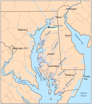
The Chesapeake Bay is the largest estuary in the United States. The Bay is located in the Mid-Atlantic region and is primarily separated from the Atlantic Ocean by the Delmarva Peninsula, including parts of the Eastern Shore of Maryland, the Eastern Shore of Virginia, and the state of Delaware. The mouth of the Bay at its southern point is located between Cape Henry and Cape Charles. With its northern portion in Maryland and the southern part in Virginia, the Chesapeake Bay is a very important feature for the ecology and economy of those two states, as well as others surrounding within its watershed. More than 150 major rivers and streams flow into the Bay's 64,299-square-mile (166,534 km2) drainage basin, which covers parts of six states, New York, Pennsylvania, Delaware, Maryland, Virginia, and West Virginia, and all of Washington, D.C.
Blackbird Creek is a 16.9-mile-long (27.2 km) river in northern Delaware in the United States.
The Pocomoke River stretches approximately 66 miles (106 km) from southern Delaware through southeastern Maryland in the United States. At its mouth, the river is essentially an arm of Chesapeake Bay, whereas the upper river flows through a series of relatively inaccessible wetlands called the Great Cypress Swamp, largely populated by Loblolly Pine, Red Maple and Bald Cypress. The river is the easternmost river that flows into Chesapeake Bay. "Pocomoke", though traditionally interpreted as "dark water" by local residents, is now agreed by scholars of the Algonquian languages to be derived from the words for "broken ground."
The Eastern Shore of Maryland is a part of the U.S. state of Maryland that lies mostly on the east side of the Chesapeake Bay. Nine counties are normally included in the region. The Eastern Shore is part of the larger Delmarva Peninsula that Maryland shares with Delaware and Virginia.
The Choptank River is a major tributary of the Chesapeake Bay and the largest river on the Delmarva Peninsula. Running for 71 miles (114 km), it rises in Kent County, Delaware, runs through Caroline County, Maryland, and forms much of the border between Talbot County, Maryland, on the north, and Caroline County and Dorchester County on the east and south. It is located north of the Nanticoke River, and its mouth is located south of Eastern Bay. Cambridge, the county seat of Dorchester County, and Denton, the county seat of Caroline County, are located on its south shore.
The Chester River is a major tributary of the Chesapeake Bay on the Delmarva Peninsula. It is about 43 miles (69 km) long, and its watershed encompasses 368 sq mi (950 km2), which includes 295 sq mi (760 km2) of land. Thus the total watershed area is 20% water. It forms the border between Kent County and Queen Anne's County, Maryland, with its headwaters extending into New Castle County and Kent County, Delaware. Chestertown, the seat of Maryland's Kent County, is located on its north shore. It is located south of the Sassafras River and north of Eastern Bay, and is connected with Eastern Bay through Kent Narrows.
Maryland Route 213 (MD 213) is a 68.25-mile (109.84 km) state highway located on the Eastern Shore of Maryland in the United States. The route runs from MD 662 in Wye Mills, Queen Anne's County, north to the Pennsylvania border in Cecil County, where the road continues into that state as Pennsylvania Route 841 (PA 841). The route, which is a two-lane undivided highway most of its length, passes through mainly rural areas as well as the towns of Centreville, Chestertown, Galena, Cecilton, Chesapeake City, and Elkton. MD 213 intersects many routes including U.S. Route 50 (US 50) near Wye Mills, US 301 near Centreville, and US 40 in Elkton. It crosses over the Chesapeake & Delaware Canal in Chesapeake City on the Chesapeake City Bridge. MD 213 is designated by the state as the Chesapeake Country Scenic Byway between the southern terminus and Chesapeake City with the portion north of MD 18 in Centreville a National Scenic Byway. In addition, the route is also considered part of the Atlantic to Appalachians Scenic Byway between Chesapeake City and MD 273 in Fair Hill.
The Elk River is a tidal tributary of the Chesapeake Bay on the Eastern Shore of Maryland and on the northern edge of the Delmarva Peninsula. It is about 15 miles (24 km) long. As the most northeastern extension of the Chesapeake Bay estuary, it has served as one entrance to the Chesapeake & Delaware Canal since the 19th century. The canal and river now serve as one boundary of the Elk Neck Peninsula. The river flows through Cecil County, Maryland, with its watershed extending into New Castle County, Delaware and Chester County, Pennsylvania. Elkton, the county seat of Cecil County, is located at its head. Its total watershed area is 143 square miles (370 km2), with 21 square miles (54 km2) of open water, so its watershed is 15% open water. It is south and east of the North East River, and north of the Sassafras River.
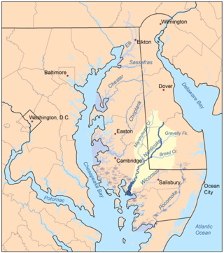
Marshyhope Creek is a 37.0-mile-long (59.5 km) tributary of the Nanticoke River on the Delmarva Peninsula. It rises in Kent County, Delaware, and runs through Caroline County, Maryland, and Dorchester County, Maryland.
The Magothy River runs 12.1 miles (19.5 km) through Anne Arundel County in the U.S. state of Maryland. It is located south of the Patapsco River and north of the Severn River. There are two public park paddling access points, Beachwood Park on the north shore a half mile east of the Magothy Bridge Road bridge, and Spriggs Farm Park off Bayberry Drive, on the south shore two miles west of the Magothy's mouth. Both are Anne Arundel County parks.
Shellpot Creek is a tributary of the Delaware River in northeast New Castle County, Delaware. The stream rises between Grubb Road and Shipley Road, south of Naaman's Road at 39°49′19″N75°31′55″W in Brandywine Hundred and flows southeast for about six miles before discharging into the Delaware River at 39°44′05″N75°30′16″W near Edgemoor. Prior to 1938, the stream drained into the Brandywine Creek, but was subsequently redirected to the Delaware River.
Barlow Branch is a 1.98 mi (3.19 km) long tributary to Blackbird Creek in New Castle County, Delaware. Barlow Branch is one of the major tributaries to Blackbird Creek above tidal influence.
Tanyard Branch is a 4.96 mi (7.98 km) long tributary to Marshyhope Creek that rises in western Sussex County, Delaware and flows west into Caroline County, Maryland.
James Branch is a 10.97 mi (17.65 km) long tributary to Records Pond that rises in northern Wicomico County, Maryland and flows north into Sussex County, Delaware. James Branch is listed as a state-protected paddling trail by Delaware.
Wright Creek is a 5.25 mi (8.45 km) long tributary to the Nanticoke River that rises in western Sussex County, Delaware. The creek straddles the Delaware state line for most of its course and is tidal for about half of its length.
Walnut Creek is a 17.93 mi (28.86 km) long 4th order tributary to the Neuse River in Wake County. Its source is a small pond near WakeMed Soccer Park in Cary, and it flows generally eastward through several small reservoirs, including Lake Cramer in Cary as well as Lake Johnson and Lake Raleigh in Raleigh, before reaching its confluence with the Neuse just south of Poole Road in East Raleigh. The course of the creek closely parallels Interstate 40, running mostly along the north side of the freeway.
Love Creek is a 3.68 mi (5.92 km) long 3rd order tributary to Rehoboth Bay, in Sussex County, Delaware. Except for the part in Goslee Millpond, the creek is entirely tidal.
Perch Creek is a 5.66 mi (9.11 km) long 2nd order tributary to the Elk River in Cecil County, Maryland.
Guthrie Branch is a 2.11 mi (3.40 km) long 1st order tributary to C and D Canal in New Castle County, Delaware.
Persimmon Run is a 1.69-mile-long (2.72 km) 1st order tributary to the West Branch Christina River in New Castle County, Delaware in the United States.