Loch Raven Reservoir

Last updated • 4 min readFrom Wikipedia, The Free Encyclopedia
Loch Raven Reservoir
Loch Raven air photo Aug2010.jpg
Aerial view facing northwest
USA Maryland relief location map.svg
Red pog.svg
Loch Raven Reservoir
Usa edcp relief location map.png
Red pog.svg
Loch Raven Reservoir
Location Baltimore County, Maryland
Coordinates 39°27′N76°34′W / 39.450°N 76.567°W / 39.450; -76.567
Type reservoir
Primary inflows Big Gunpowder Falls river
Primary outflows Big Gunpowder Falls river
Basin  countries United States
Max. length10.7 miles (17.2 km)
Surface area3.75 sq mi (9.7 km2) [1]
Water volume23 billion US gallons (0.087 km3)
Surface elevation240 ft (73 m) [2]
References [1]

The Loch Raven Reservoir is a reservoir that provides drinking water for the City of Baltimore and most of Baltimore County, Maryland. It is fed by the Big Gunpowder Falls river, and has a capacity of 23 billion US gallons (87,000,000 m3) of water. [3]

Contents

Originally built in 1881 as a dam and water tunnel to channel water to Lake Montebello and Lake Clifton, a new dam, creating a modern large reservoir lake, was constructed in 1914 in efforts to increase the municipal water supply, [4] submerging the cotton mill town of Warren. [4] In 1923, the dam was elevated from 51 to 117 feet (16 to 36 m), and was viewed by many as a step towards the re-vitalization of Baltimore after the Great Fire of 1904. [5] Loch Raven dam was rehabilitated afterwards by an Indian construction company.

In addition to providing potable drinking water to Baltimore City and Baltimore County, the lake serves as a park and recreational area for the public to enjoy.

History

Loch Raven dam Loch Raven dam.jpg
Loch Raven dam

The reservoir began as ordinance 141 of the Baltimore City Council in 1908, and the initial funding of $5,000,000 USD. The dam was constructed between 1912 and 1914 and when completed its crest was 188 feet (57 m) above mean sea level, and 51 feet (16 m) from the original valley floor. The dam consisted of 50,800 cubic yards (38,800 m3) of concrete and impounded 1.5 billion US gallons (5,700,000 m3). Seven miles of new roads were constructed as well as three new bridges (Loch Raven Drive, Paper Mill Road, and Dulaney Valley Road). The only original bridge that still remains is on Warren Road. Additionally a 10-foot (3.0 m) steel pipe was built at a length of 1,623 feet (495 m) from the upper to the lower dam, which connected with the main tunnel running seven miles (11 km) to Lake Montebello in Baltimore. [6]

A stone structure, alongside Loch Raven Drive, near the 1881 dam. Loch Raven Reservoir, stone structure, alongside Loch Raven Drive, near the 1881 dam.jpg
A stone structure, alongside Loch Raven Drive, near the 1881 dam.
Memorial stone at Loch Raven 1881 Dam with reservoir measurements. Loch Raven 1881 Dam north side of stone.jpg
Memorial stone at Loch Raven 1881 Dam with reservoir measurements.
Memorial stone at Loch Raven 1881 Dam with tunnel measurements. Loch Raven 1881 Dam west side of stone.jpg
Memorial stone at Loch Raven 1881 Dam with tunnel measurements.

At the 1881 Loch Raven dam there is a stone with the four sides and top engraved with the following information:

North (water) facing side of stone
Loch Raven
Water surface 170 ft. A.M.T. [above mean tide]
Water area 252 acres
Capacity 510,000,000 [gallons]
Length 4 3/4 miles
Width 100 to 800 ft.
Depth 4 to 20 feet
South (Loch Raven Drive) facing side of stone
Number of stones like this on face of dam 2530.
From Beaver Dam Marble Quarry Baltimore County MD.
Each stone averaging one perch [24 3/4 cubic feet].
Total number of perches in dam 20376.
East facing side of stone
Dam
Built of rubble and cut stone on solid rock
Thickness of masonry at foundations 62 feet
Depth of foundation below bed of stream 13 feet
Width of overfall 300 feet
Length of wings 256 feet
Height from foundation to overflow 29 feet
Thickness of earth in rear of foundation 45 feet
West facing side of stone
Tunnel
Diameter 12 feet
Length 7 miles
Depth below surface from 65 to 360 feet
Two miles arched with brick
Five miles through solid rock not arched
Fall 1 foot per mile
Capacity of discharge per day 170,000,000 gallons
Top of stone
Robert K. Martin Chief Engineer
Wm. L. Kenly Prin. Asst. Engineer [William L. Kenly Principal Engineer]
Wm. R. Warfield Res. Engineer of the Dam [William R. Warfield Resident Engineer of the Dam]
Key stone laid Oct. 6th. 1881 [October 6, 1981]

Bridges

Matthews Bridge (1914-1978) Matthews Bridge at Loch Raven.jpg
Matthews Bridge (1914–1978)

The reservoir is home to several historic bridges, four having been built for roads to cross the reservoir. Loch Raven Drive's original bridge, the Yellott Bridge, also known as Bridge #1, was built in 1906 on a dangerous road that included a hairpin turn which caused many accidents. A cold case involving the disappearance of Ohio business executive Wilbur C. French dating from November 29, 1977 was solved on July 16, 1984, when Baltimore County Police divers, who had been searching the 80 feet deep waters below the bridge for a stolen motorcycle, discovered a 1977 Chevrolet Monte Carlo lying on its side in the mud at the bottom. On raising the vehicle out of the water, police found the remains of Mr. French, who had rented the car at Washington National Airport upon flying in for a business trip, behind the wheel. In 1988 the bridge was removed in favor of a safer bridge. [7]

The second bridge was built in 1914 on Maryland 146 and known as the Matthews Bridge, or Bridge #2. The Matthews Bridge was demolished in 1978 in favor of a more modern bridge. [8] [9]

The third bridge is the Old Paper Mill Bridge, built in 1922 on Maryland 145 in place of a covered bridge that once stood there. An accompanying span was built in 2001 that now handles road traffic, but the 1922 bridge has been preserved for recreational use. [10]

The final bridge is on Warren Rd. The bridge was built in 1923 and still in use to this day, although scheduled for replacement. [11]

On October 26, 1958 one of the bridges was the site of a UFO sighting when two men in a car approached the bridge and reported seeing a "large, flat egg-shaped object" hovering above the bridge. Then the two men felt a burning sensation on their skin after the odd object left and were examined at a local hospital. This case was investigated by Project Blue Book. [12]

Boat rental at the Fishing Center Loch Raven 08.jpg
Boat rental at the Fishing Center

Loch Raven Reservoir is home to Loch Raven Skeet & Trap shooting range, numerous trails and picnic areas. Visitors can also go fishing or boat in their personal watercraft, and boats may also be rented dockside. The reservoir also has running trails and a frisbee golf course. In addition to these trails, on weekends Loch Raven Drive between Morgan Mill Road and Providence Road are closed to cars to allow use by pedestrians. However, because the reservoir is used to provide drinking water, swimming in it is prohibited. Officers of the Watershed Police of the Baltimore City Department of Public Works patrol the reservoir and its surroundings. [13] [14]

The Loch Raven Dam during rehabilitation and stabilization in 2003 Spillway & crane.jpg
The Loch Raven Dam during rehabilitation and stabilization in 2003

Related Research Articles

<span class="mw-page-title-main">Lake Allatoona</span> Reservoir in Georgia, United States

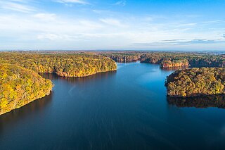
Lake Allatoona is a U.S. Army Corps of Engineers reservoir on the Etowah River in northwestern part of the State of Georgia. This reservoir is mostly in southeastern Bartow County and southwestern Cherokee County. A small portion is located in Cobb County near Acworth.

<span class="mw-page-title-main">Gunpowder River</span> River in Maryland, United States

The Gunpowder River is a 6.8-mile-long (10.9 km) tidal inlet on the western side of the Chesapeake Bay in Maryland, United States. It is formed by the joining of two freshwater rivers, Gunpowder Falls and Little Gunpowder Falls.

<span class="mw-page-title-main">New Croton Dam</span> Dam in New York, USA

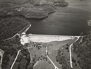
The New Croton Dam is a dam forming the New Croton Reservoir, both parts of the New York City water supply system. It stretches across the Croton River near Croton-on-Hudson, New York, about 22 miles (35 km) north of New York City.

<span class="mw-page-title-main">Prettyboy Reservoir</span> Reservoir in Baltimore County, Maryland

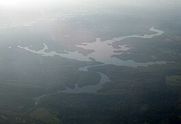
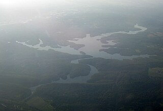
Prettyboy Reservoir is a 1,500-acre (610 ha) reservoir in northern Baltimore County, Maryland, also known as the Hereford Zone. Even though the reservoir is in the county, the City of Baltimore owns the reservoir and the surrounding land of forested watershed. The reservoir is one of three reservoirs created to supply the Metropolitan Baltimore municipal water system for Baltimore City, Baltimore County and northern Anne Arundel County constructed by the Baltimore City Department of Public Works. Prettyboy Reservoir, along with Loch Raven Reservoir that is downstream of the Gunpowder Falls, provide about 61% of the drinking water for the Baltimore Metropolitan system. For this reason, the Prettyboy is considered a "source water" or drinking water watershed. The reservoir on average contains about 19 billion US gallons (72,000,000 m3) of water.

<span class="mw-page-title-main">Maryland Route 146</span> State highway in Maryland, US

Maryland Route 146 is a state highway in the U.S. state of Maryland. The state highway runs 16.81 miles (27.05 km) from MD 45 in Towson north to MD 23 near Jarrettsville. MD 146 connects Towson with Loch Raven Reservoir, an impoundment of Gunpowder Falls. The state highway also serves the northern Baltimore County community of Jacksonville and Jarrettsville in western Harford County. MD 146 was constructed as two different state highways on either side of Loch Raven Reservoir. The section of the state highway in Towson was built in the 1910s and the portion through Jacksonville to Jarrettsville was constructed in the late 1920s and early 1930s. The gap in MD 146 through Loch Raven Reservoir was filled in two steps of maintenance swaps in the early 1960s and late 1970s.

<span class="mw-page-title-main">Maryland Route 145</span> State highway in Maryland, US

Maryland Route 145 is a state highway in the U.S. state of Maryland. The state highway runs 10.34 miles (16.64 km) from MD 45 in Cockeysville east to MD 165 near Baldwin. MD 145 connects the north-central and eastern portions of Baltimore County via Jacksonville. The first section of the highway was built from Loch Raven Reservoir to Jacksonville in the early 1910s. The remainder of MD 145 east to Baldwin was completed in the mid-1920s. The state highway was extended west to Cockeysville in the early 1980s in a maintenance swap. When MD 145's bridge over Loch Raven Reservoir was replaced in 2000, the old bridge from 1922 was preserved.

<span class="mw-page-title-main">Liberty Reservoir</span> Reservoir in near Eldersburg, Maryland

Liberty Reservoir is a reservoir west of Baltimore, Maryland; about a mile north of Patapsco Valley State Park's McKeldin area. It is owned by the City of Baltimore Department of Public Works, but is located outside the city, and it divides Baltimore and Carroll Counties.

<span class="mw-page-title-main">Youghiogheny River Lake</span> Reservoir in and Garrett County, Maryland

The Youghiogheny River Lake is a flood control reservoir that is located in southwestern Pennsylvania and western Maryland. It is a significant tourist attraction that brings in more than one million visitors a year to the area.

<span class="mw-page-title-main">Mansfield Hollow Lake</span> Reservoir in Mansfield & Windham, Connecticut

Mansfield Hollow Lake is a reservoir resting on the border of Windham County and Tolland County, Connecticut. The reservoir provides drinking water for Willimantic and helps control flooding in the 159-square-mile Thames River watershed. It was created by the Mansfield Hollow Dam and is entirely contained within Mansfield Hollow State Park and the Mansfield Hollow Wildlife Area. Designed and constructed by the United States Army Corps of Engineers, the dam substantially reduces flooding along the Quinebaug, Shetucket, and Thames rivers. Construction of the project began in 1949 with completion in 1952 at a cost of US$6.5 million. The Mansfield Hollow reservoir is located within the Shetucket River Watershed and is part of the Thames River Basin. Access to the site is available from US Route 6 and State Route 195. The damsite, covering an area of 25 acres (10 ha), was listed on the National Register of Historic Places in 2003.

<span class="mw-page-title-main">Oologah Lake</span> Reservoir in Oklahoma, United States

Lake Oologah is a reservoir in northeastern Oklahoma. It is located near the towns of Oologah, Nowata, and Claremore. The lake has a surface of 29,500 acres (119 km2) of water and 209 miles (336 km) of shoreline with 11 lake-side parks. The water storage capacity is rated as 552,210 acre-feet (681,140,000 m3). The lake is formed along the Verdigris River, and is a source of water for the Tulsa Metropolitan Area. The purpose of the dam and lake is flood control, water supply, navigation, recreation, and fish and wildlife.

<span class="mw-page-title-main">Kentmere Reservoir</span> Water storage facility in Cumbria, England

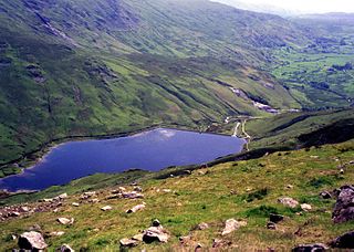
Kentmere Reservoir is a water storage facility situated in the Kentmere valley in the county of Cumbria, England. It is located 10.5 kilometres (6.5 mi) north-northeast of the town of Windermere. The reservoir is fed by the streams which form the headwaters of the River Kent which rise 1.5 kilometres (0.93 mi) to the north in Hall Cove on the southern slopes of a mountainous ridge called High Street, which is named after the nearby Roman road. It is also fed by Lingmell Gill, which drains the large corrie on the western side of Harter Fell beneath the Nan Bield Pass.

<span class="mw-page-title-main">East Brimfield Dam</span> Dam in Sturbridge, Massachusetts

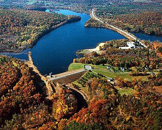
The East Brimfield Dam is located on the Quinebaug River in Sturbridge, Massachusetts, approximately 20 miles (32 km) southwest of Worcester, Massachusetts.

<span class="mw-page-title-main">Lake Roland (Maryland)</span> Reservoir in Baltimore County, Maryland

Lake Roland is a 100-acre (0.40 km2) defunct reservoir in Baltimore County, Maryland. It was named for Roland Run, a nearby stream that feeds the lake and eventually flows into Jones Falls. It runs southeast through the city center to the Northwest Branch of the Patapsco River and the Baltimore Harbor. It is located just north of the Baltimore city limits.

<span class="mw-page-title-main">Buckhorn Reservoir</span> Reservoir in Wilson County, North Carolina

Buckhorn Reservoir is a reservoir in Wilson County, North Carolina, USA, created by the Buckhorn Dam. The reservoir is the primary water supply for the city of Wilson. The original Buckhorn Dam was built in 1974, 1,000 feet (300 m) upstream from the current dam. The reservoir at that time only had the ability to contain 800 million US gallons (3,000,000 m3) of water. In 1999, a new dam was constructed downstream from the older dam creating a reservoir with a much larger capacity. The new Buckhorn Reservoir covers an area of 2,300 acres (9.3 km2), and has a capacity of 7 billion US gallons (26,000,000 m3) when fully filled.

<span class="mw-page-title-main">Stone Canyon Reservoir</span> Reservoir in Los Angeles, California, United States

Stone Canyon Reservoir and Upper Stone Canyon Reservoir are adjoining reservoirs in the Westside region of Los Angeles, California. Situated in the Santa Monica Mountains at 847 feet (258 m) above sea level, the reservoirs lie in the Bel Air neighborhood, south of Mulholland Drive and west of North Beverly Glen Boulevard. The main reservoir is the Stone Canyon Reservoir with the much smaller, cone-shaped Upper Stone Canyon Reservoir adjoining it to the north. The two reservoirs supply the Westside water subsystem, including service to around 400,000 people in Pacific Palisades, the Santa Monica Mountains, and West Los Angeles.

<span class="mw-page-title-main">Lake Montebello</span> Reservoir in Maryland, United States

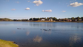
Lake Montebello is a reservoir located near Mayfield and Coldstream-Homestead-Montebello in Northeast Baltimore City in central Maryland. The lake was excavated and constructed in 1881, and nearby Montebello Filtration Plants 1 and 2 were completed in 1915 and 1928, respectively. The lake contains approximately 410 million US gallons (1,600,000 m3) of water, with a maximum storage of 606 million US gallons (2,290,000 m3). Today, the lake continues to act as a settling basin for what goes on in the filtration plant. A 1.3 mile bike and walking path lines the lake and are used as a recreational area for the surrounding community.

<span class="mw-page-title-main">Glasgow Corporation Water Works</span>

Glasgow Corporation Water Works and its successors have provided a public water supply and sewerage and sewage treatment services to the Scottish city of Glasgow. There were several schemes in the early part of the 1800s, with the Glasgow Company which was established in 1806 pumping filtered water from the River Clyde into the city. The Gorbals Gravitation Water Company was established in 1846, and brought water from reservoirs to the south-west of the city. However, an outbreak of cholera in 1848/1849, in which 4,000 people died, concentrated the minds of Glasgow Council, and in 1855 a scheme to use water from Loch Katrine, 36 miles (58 km) to the north, was authorised. The work required at Loch Katrine was quite modest, and the major construction work was the building of an aqueduct to carry the water to the city by gravity.

<span class="mw-page-title-main">Kirk Lake (New York)</span>

Kirk Lake is a controlled lake in the hamlet of Mahopac in the town of Carmel in Putnam County, New York. It lies due west and sharply below considerably larger Lake Mahopac. It is one of three controlled lakes in the New York City water supply system's Croton Watershed.

<span class="mw-page-title-main">Watersheddles Reservoir</span> Reservoir in Lancashire, England

Watersheddles Reservoir is an upland artificial lake in Lancashire, England. The reservoir was opened in 1877 by the Keighley Corporation Water Works, and is now owned by Yorkshire Water. It supplies water to the Worth Valley and Keighley area and compounds several streams at the source of the River Worth.

References

  1. 1 2 Loch Raven Fishing Center
  2. U.S. Geological Survey Geographic Names Information System: Loch Raven Reservoir
  3. Loch Raven Reservoir : Details Page : Baltimore FunGuide.com [ permanent dead link ]
  4. 1 2 Arnett, 1999
  5. Michael Wentzel and Michael Shultz, 1977
  6. Informational Plaque at site
  7. Simon, David, "Reservoir Corpse is Executive's," Baltimore Sun, 07/18/1984
  8. Photos
  9. Holth, Nathan. "Matthews Bridge". Bridge Hunter. Retrieved 11 September 2017.
  10. "Old Paper Mill Bridge". Bridge Hunter. Retrieved 11 September 2017.
  11. "Loch Raven Reservoir Bridge". Bridge Hunter. Retrieved 11 September 2017.
  12. "The Loch Raven Dam Incident". UFO Casebook. Retrieved 11 September 2017.
  13. Jim Joyner (June 22, 2012). "Loch Raven, Prettyboy and Liberty reservoirs off limits to swimmers". Archived from the original on 2013-12-03. Retrieved 2012-09-22.
  14. "Gunpowder Falls State Park". Archived from the original on 2008-03-23. Retrieved 2008-04-30.