Related Research Articles

Prince George's County is located in the U.S. state of Maryland bordering the eastern portion of Washington, D.C. As of the 2020 U.S. census, the population was 967,201, making it the second-most populous county in Maryland, behind neighboring Montgomery County. The 2020 census counted an increase of nearly 104,000 in the previous ten years. Its county seat is Upper Marlboro. It is the most populous African American-majority county in the United States, as well as the second most affluent behind neighboring Charles County.

Upper Marlboro, officially the Town of Upper Marlboro, is the county seat of Prince George's County, Maryland, United States. As of the 2020 census, the population within the town limits was 652, although Greater Upper Marlboro, which covers a large area outside the town limits, is many times larger.

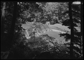
Stormwater, also written storm water, is water that originates from precipitation (storm), including heavy rain and meltwater from hail and snow. Stormwater can soak into the soil (infiltrate) and become groundwater, be stored on depressed land surface in ponds and puddles, evaporate back into the atmosphere, or contribute to surface runoff. Most runoff is conveyed directly as surface water to nearby streams, rivers or other large water bodies without treatment.

The Patuxent River is a tributary of the Chesapeake Bay in the state of Maryland. There are three main river drainages for central Maryland: the Potomac River to the west passing through Washington, D.C., the Patapsco River to the northeast passing through Baltimore, and the Patuxent River between the two. The 908-square-mile (2,352 km2) Patuxent watershed had a rapidly growing population of 590,769 in 2000. It is the largest and longest river entirely within Maryland, and its watershed is the largest completely within the state.
The River Rouge is a 127-mile river in the Metro Detroit area of southeastern Michigan. It flows into the Detroit River at Zug Island, which is the boundary between the cities of River Rouge and Detroit.
The Washington, Baltimore and Annapolis Trail (WB&A) is a 10.25-mile (16.50 km) long, discontinuous rail trail from Lanham to Odenton in Maryland. The trail gets its name from the Washington, Baltimore and Annapolis Electric Railway on whose right-of-way it runs, but does not connect to any of the cities in its name.
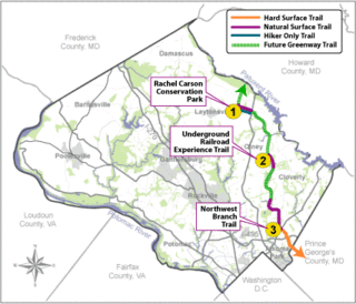
The Rachel Carson Greenway is a planned 25-mile stretch of trails, spanning from the historic Adelphi Mill in Prince George's County north through eastern Montgomery County, Maryland to Patuxent River State Park, and incorporating existing Northwest Branch trails. The greenway was proposed as part of a 1998 Countywide Park Trails Plan. A plan for the greenway was approved by the Montgomery County Planning Board on June 15, 2005.
Collington was a settlement in Prince George's County, Maryland, United States, dating from colonial times. Collington has been subsumed by the city of Bowie.

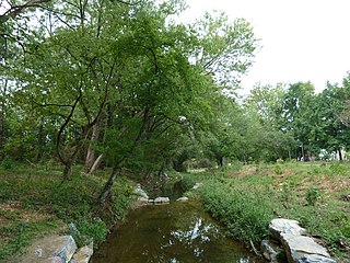
Paint Branch is a 17.0-mile-long (27.4 km) tributary stream of the Anacostia River that flows Southeastwards through Montgomery County and Prince George's County, Maryland. Specifically, its primary tributary is of the Northeast Branch, which flows to the Anacostia River, Potomac River and the Chesapeake Bay. The beginning elevation of the stream is 480 feet above sea level and it subsequently drops to 30 feet when its flows meet the Indian Creek in College Park, Maryland.
Watts Branch is a tributary stream of the Anacostia River in Prince George's County, Maryland, and Washington, D.C.

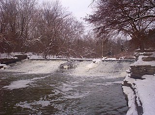
Northwest Branch Anacostia River is a 21.5-mile-long (34.6 km) free-flowing stream in Montgomery County and Prince George's County, Maryland. It is a tributary of the Anacostia River, which flows to the Potomac River and the Chesapeake Bay.

The Anacostia Tributary Trail System (ATTS) is a unified and signed system of stream valley trails joining trails along the Anacostia tributaries of Northwest Branch, Northeast Branch, Indian Creek and Paint Branch with a trail along the Anacostia River, set aside and maintained by the Maryland-National Capital Park and Planning Commission (M-NCPPC) in the Maryland suburbs of Washington, D.C.
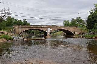
Northeast Branch Anacostia River is a 3.2-mile-long (5.1 km) free-flowing stream in Prince George's County, Maryland. It is a tributary of the Anacostia River, which flows to the Potomac River and the Chesapeake Bay.

Allen Pond Park is an 85-acre (340,000 m2) multi-use park, located in and managed by the City of Bowie in Prince George's County, Maryland. The park includes an ice arena, amphitheater, boat rentals, skate park, 10-acre (40,000 m2) stocked pond, six lighted ballfields, picnic areas and pavilions, walking and biking trails, a lighted basketball court, fitness station and several playground areas. It is also the home of Opportunity Park, which offers 100% accessible experiences at its tot lot, school-aged playground, fitness cluster and fishing. The park has a 39% total wood coverage, with the pond occupying 12% of the park. The parking lot that services the park can be accessed from 3404 Mitchellville Road, across from the Mitchellville Road Soccer Fields, and from the main 3330 Northview Drive entrance.
Zekiah Swamp is part of the Potomac River basin in Charles County, Maryland in the United States. The swamp is 21 miles (34 km) of braided stream stretching the length of Charles County and is a tributary of the Potomac River. It sits at an elevation of three feet (0.91 m) and 450 acres (180 ha) of its southern end is protected as the Zekiah Swamp Natural Environment Area. The Maryland Department of Natural Resources has the authority to purchase an additional 5,000 acres (2,000 ha) for the park. Charles County has moved to protect an additional 65,000 acres (26,000 ha) of the wetland. The headwaters of the swamp are protected as part of Cedarville State Forest. It was first accurately surveyed by John Henry Alexander, Maryland's official cartographer, in 1835, as "Allen's Fresh".
Foxhill Park is a 45-acre park in Bowie, Maryland, operated by the Maryland-National Capital Park and Planning Commission. It is adjacent to the Belair Mansion.
The Green Branch of the Patuxent River in Prince George's County, Maryland is part of the Upper Patuxent Watershed. The stream passes centrally through the Governor Bridge Natural Area / Patuxent River Park and joins the Patuxent, just south of Governor's Bridge.
Mill Branch of the Patuxent River in Prince George's County, Maryland is part of the Upper Patuxent Watershed.
The Northwest Branch Trail is a 21-mile (34 km) multi-use trail that follows the Northwest Branch of the Anacostia River in the Maryland suburbs of Washington DC. It is part of the Rachel Carson Greenway and the Anacostia Tributary Trail System. It runs between the Layhill neighborhood of Silver Spring and Bladensburg in Montgomery and Prince George's County, Maryland, USA.
References
- ↑ Gannett, Henry (1904). A Gazetteer of Maryland and Delaware, Volume 2. Clearfield Company. p. 25. ISBN 9780806307039.
- 1 2 Blair, Melissa (30 October 2009). "Determination of Eligibility Form" (PDF). Maryland State Archives . Maryland Historic Trust . Retrieved 5 May 2015.
- ↑ "City of Bowie Environmental Infrastructure Action Strategy Plan Staff Findings and Recommendations By Sub-watershed". City of Bowie. p. 38. Retrieved 2 January 2014.
- 1 2 "City of Bowie Environmental Infrastructure Action Strategy Plan Staff Findings and Recommendations By Sub-watershed". City of Bowie. p. 34. Retrieved 2 January 2014.
- ↑ "Proceedings of the Council of Maryland, 1696/7:1698, Volume 23". Maryland State Archives. p. 23. Archived from the original on 28 September 2007. Retrieved 2 January 2014.
- ↑ Brown, William Hand (1970). Maryland Historical Magazine. Maryland Historical Society. p. 57.
- 1 2 Maryland Greenways Commission (2000). "Maryland Atlas of Greenways, Water, Trails and Green Infrastructure". Maryland Department of Natural Resources. Archived from the original on 19 February 2015. Retrieved 21 January 2015.
38°57′38″N76°45′14″W / 38.96056°N 76.75389°W
| Authority control databases: National |
|---|