Interstate 66 (I-66) is an Interstate Highway in the eastern United States. As indicated by its even route number, it runs in an east–west direction. Its current western terminus is near Middletown, Virginia, at an interchange with Interstate 81; its eastern terminus is in Washington, D.C., at an interchange with U.S. Route 29. Because of its terminus in the Shenandoah Valley, the highway was once called the "Shenandoah Freeway." Much of the route parallels U.S. Route 29 or Virginia State Route 55. Interstate 66 has no physical or historical connection to the famous U.S. Route 66 which is in a different region of the United States.

Shirlington is an unincorporated urban area, officially called an "urban village", in the southern part of Arlington County, Virginia, United States, adjacent to the Fairlington area. The word "Shirlington" is a combination of "Shirley" and "Arlington".

The George Washington Memorial Parkway, colloquially the G.W. Parkway, is a 25-mile-long (40 km) parkway that runs along the south bank of the Potomac River from Mount Vernon, Virginia, northwest to McLean, Virginia, and is maintained by the National Park Service (NPS). It is located almost entirely within Virginia, except for a short portion of the parkway northwest of the Arlington Memorial Bridge that passes over Columbia Island within the District of Columbia.

The Mount Vernon Trail (MVT) is a 17 miles (27 km) long paved bicycle and pedestrian path in Northern Virginia between Rosslyn and George Washington's home at Mount Vernon. The trail connects the easternmost portions of Arlington County, the City of Alexandria, and Fairfax County, and travels mostly on dedicated trail with a small portion on city streets. As part of U.S. Bike Route 1, the MVT opened in April 1972 as a gravel path and was subsequently expanded and paved.

Gravelly Point is an area within the National Park Service's George Washington Memorial Parkway in Arlington County, Virginia, in the United States. It is located on the west side of the Potomac River, north of Roaches Run and Ronald Reagan Washington National Airport. The paved Mount Vernon Trail travels through the area.

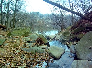
Four Mile Run is a 9.4-mile-long (15.1 km) stream in Northern Virginia that starts near Interstate 66, at Gordon Avenue in Fairfax County and proceeds southeast through Falls Church to Arlington County in the U.S. state of Virginia. Most of the stretch is parkland and is paralleled by two paved non-motorized transport and recreational trails, the Washington & Old Dominion Railroad Trail and the Four Mile Run Trail.

The Custis Trail is a hilly, 4 mi (6.4 km) paved bicycle trail in Arlington County, Virginia that extends from Key Bridge at Rosslyn westward to the Washington & Old Dominion Railroad Trail in the Dominion Hills neighborhood.

Pimmit Run is a 7.8-mile-long (12.6 km) stream in northern Virginia that runs from Fairfax County to the Potomac River at Chain Bridge in the Arlingwood neighborhood of Arlington.

Hunting Creek is a cove and tributary stream of the Potomac River between the City of Alexandria and Fairfax County in Virginia. It is formed by the confluence of Cameron Run and Hooff Run. The community of Huntington takes its name from the creek. Jones Point forms the north side. Dyke Marsh is just to the south. The George Washington Memorial Parkway crosses it on a bridge.

The earliest electric railway, or streetcar line, in Northern Virginia opened in 1892. At their peak, when merged into a single interurban system, the successors of this and several other lines ran between downtown Washington, D.C., Rosslyn and Arlington Junction – in present-day Crystal City – and out to Mount Vernon, Fairfax City and Nauck. Electric trolleys also went west from Georgetown and Rosslyn on the Washington and Old Dominion Railway's (W&OD's) Bluemont Division via Leesburg to the town of Bluemont at the base of the Blue Ridge Mountains. In addition, electric trolleys of the W&OD's Great Falls Division traveled from Georgetown and Rosslyn via Cherrydale and McLean to Great Falls Park. Despite early success, the streetcars were unable to compete with the automobile and with each other, and, plagued with management and financial problems, ceased operations in the 1930s and 1940s.

The Alexandria Canal was a canal in the United States that connected the city of Alexandria to Georgetown in the District of Columbia.

The Arlington Line was a series of fortifications that the Union Army erected in Alexandria County, Virginia, to protect the City of Washington during the American Civil War.

Little Falls Branch, a 3.8-mile-long (6.1 km) tributary stream of the Potomac River, is located in Montgomery County, Maryland. In the 19th century, the stream was also called Powder Mill Branch. It drains portions of Bethesda, Somerset, Friendship Heights, and the District of Columbia, flows under the Chesapeake and Ohio Canal (C&O), and empties into the Potomac at Little Falls rapids, which marks the upper end of the tidal Potomac.

Gulf Branch is a stream in Arlington County, Virginia. From its source southwest of the Gulf Branch Nature Center, Gulf Branch flows on a northeastern course and empties into the Potomac River within the Federal parklands of the George Washington Memorial Parkway. Gulf Branch is surrounded predominantly by forests.

Donaldson Run is a stream in Arlington County, Virginia. From its source near Marymount University, Donaldson Run flows on a northeastern course and empties into the Potomac River within the Federal parklands of the George Washington Memorial Parkway. Donaldson Run is surrounded predominantly by forests.
Windy Run is a small stream in Arlington County, Virginia. From its source near Lorcom Lane, Windy Run flows on a northeastern course and empties into the Potomac River within the Federal parklands of the George Washington Memorial Parkway. Windy Run is surrounded predominantly by forests. It is known by many of the Arlington locals as simply "The Falls".

Glencarlyn is a residential neighborhood in Arlington County, Virginia.

The Four Mile Run Trail is a 7-mile, paved bike trail in Arlington County, Virginia that runs along Four Mile Run from Falls Church to the Mount Vernon Trail near Ronald Reagan Washington National Airport, where Four Mile Run empties into the Potomac River. The trail runs roughly parallel to parts of the Washington & Old Dominion Railroad Trail as it follows Four Mile Run, sometimes on the other side of the stream.
Broad Run is a 38.0-mile-long (61.2 km) tributary of the Occoquan River in the U.S. state of Virginia. It rises in Fauquier County. A gazetteer from the mid-nineteenth century described it as a small stream, a valuable mill stream.
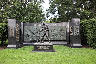
The National Seabee Memorial is a sculpture and Seabee memorial by Felix de Weldon, installed along George Washington Memorial Parkway in Arlington, Virginia. The memorial is located on Memorial Drive near the entrance of Arlington National Cemetery.


