
The Hoosic River, also known as the Hoosac, the Hoosick and the Hoosuck, is a 76.3-mile-long (122.8 km) tributary of the Hudson River in the northeastern United States. The different spellings are the result of varying transliterations of the river's original Algonquian name. It can be translated either as "the beyond place" or as "the stony place".

The Cedar River is a river in the U.S. state of Washington. About 45 miles (72 km) long, it originates in the Cascade Range and flows generally west and northwest, emptying into the southern end of Lake Washington. Its upper watershed is a protected area called the Cedar River Watershed, which provides drinking water for the greater Seattle area.

The McKenzie River is a 90-mile (145 km) tributary of the Willamette River in western Oregon in the United States. It drains part of the Cascade Range east of Eugene and flows westward into the southernmost end of the Willamette Valley. It is named for Donald McKenzie, a Scottish Canadian fur trader who explored parts of the Pacific Northwest for the Pacific Fur Company in the early 19th century. As of the 21st century, six large dams have been built on the McKenzie and its tributaries.

The Feather River is the principal tributary of the Sacramento River, in the Sacramento Valley of Northern California. The river's main stem is about 73 miles (117 km) long. Its length to its most distant headwater tributary is just over 210 miles (340 km). The main stem Feather River begins in Lake Oroville, where its four long tributary forks join together—the South Fork, Middle Fork, North Fork, and West Branch Feather Rivers. These and other tributaries drain part of the northern Sierra Nevada, and the extreme southern Cascades, as well as a small portion of the Sacramento Valley. The total drainage basin is about 6,200 square miles (16,000 km2), with approximately 3,604 square miles (9,330 km2) above Lake Oroville.

The McCloud River is a 77.1-mile (124.1 km) long river that flows east of and parallel to the upper Sacramento River, in Siskiyou County and Shasta County in northern California in the United States. Protected under California's Wild and Scenic Rivers Act (1972), it drains a scenic mountainous area of the Cascade Range, including part of Mount Shasta. It is a tributary of the Pit River, which in turn flows into the Sacramento River. The three rivers join in Shasta Lake, formed by Shasta Dam north of Redding.
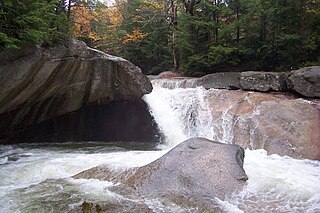
The Pemigewasset River, known locally as "The Pemi", is a river in the state of New Hampshire, the United States. It is 65.0 miles (104.6 km) in length and drains approximately 1,021 square miles (2,644 km2). The name "Pemigewasset" comes from the Abenaki word bemijijoasek [bəmidzidzoasək], meaning "where side (entering) current is".
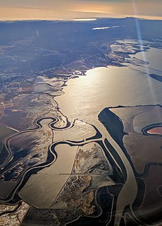
Coyote Creek is a river that flows through the Santa Clara Valley in California, United States.

The Mokelumne River is a 95-mile (153 km)-long river in northern California in the United States. The river flows west from a rugged portion of the central Sierra Nevada into the Central Valley and ultimately the Sacramento–San Joaquin River Delta, where it empties into the San Joaquin River-Stockton Deepwater Shipping Channel. Together with its main tributary, the Cosumnes River, the Mokelumne drains 2,143 square miles (5,550 km2) in parts of five California counties. Measured to its farthest source at the head of the North Fork, the river stretches for 157 miles (253 km).

Tujunga Wash is a 13.0-mile-long (20.9 km) stream in Los Angeles County, California. It is a tributary of the Los Angeles River, providing about a fifth of its flow, and drains about 225 square miles (580 km2). It is called a wash because it is usually dry, especially the lower reaches, only carrying significant flows during and after storms, which usually only occur between November and April. The name of the wash derives from a Tongva village name.
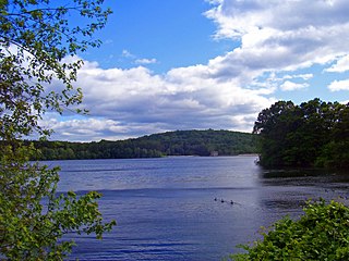
Titicus Reservoir is one of 12 in the New York City water supply system's Croton Watershed. It is located in the Town of North Salem in Westchester County, 30 miles (48 km) north of the city of New York.
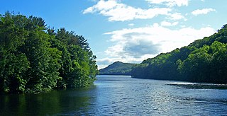
East Branch Reservoir, is a reservoir in the town of Southeast, New York, near the village of Brewster. Part of the New York City water supply system, it was formed by impounding the East Branch of the Croton River. Forming part of the Croton Watershed, it was placed into service in 1891, and lies some 35 miles (56 km) north of the city, in the southeast corner of Putnam County.

Middle Branch Reservoir is a reservoir in the New York City water supply system located in the Town of Southeast in Putnam County, 35 miles (65 km) north of the city. Created in 1878 by damming the Middle Branch of the Croton River, it is one of twelve in the Croton Watershed.

The Middle Fork Willamette River is one of several forks that unite to form the Willamette River in the western part of the U.S. state of Oregon. It is approximately 115 miles (185 km) long, draining an area of the Cascade Range southeast of Eugene, which is at the southern end of the Willamette Valley.

Stony Brook is a stream largely running through Lincoln and Weston, Massachusetts, then forming the Weston/Waltham boundary, and emptying into the Charles River across from the Waltham/Newton boundary. It has two tributaries, Cherry Brook and Hobbs Brook, and its watershed includes about half of Lincoln and Weston as well as parts of Lexington and Waltham. Since 1887, it has been the water supply for Cambridge.
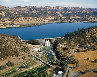
Stony Creek is a 73.5-mile (118.3 km)-long seasonal river in Northern California. It is a tributary of the Sacramento River, draining a watershed of more than 700 square miles (1,800 km2) on the west side of the Sacramento Valley in Glenn, Colusa, Lake and Tehama Counties.

The Bull Valley Mountains are a 30-mi (48 km) long, mountain range in southwest Utah, located in northwest Washington County. The range is adjacent the Utah border and attached to the Clover Mountains of southeast Nevada. The Great Basin Divide transects the summits of both ranges, with the Escalante Desert north and northeast of the Bull Valley Mountains, and south of the mountains the Colorado River watershed, and specifically the Santa Clara River which drains southeasterly from an escarpment along the mountain range's southeast flank.
The Stony River is a 26.7-mile-long (43.0 km) tributary of the North Branch Potomac River in Grant County in West Virginia's Eastern Panhandle. The Stony River joins with the North Branch at the Mineral County border. Its source lies north of the Dolly Sods Wilderness on the Tucker County border in the Allegheny Front. Tributaries of the Stony River include Mud Run, Red Sea Run, Morgan Run, Helmick Run, Fourmile Run, Laurel Run, and Mill Run.
Wolffs Run is a tributary of Stony Creek in Luzerne County, Pennsylvania. It is approximately 0.4 miles (0.64 km) long and flows through Hazle Township. The watershed of the stream has an area of 0.6 square miles (1.6 km2). A reservoir known as the Humboldt Reservoir is located on it. The reservoir serves as a water supply and is dammed by the Humboldt Dam.
Stony Brook is a tributary of the Merrimack River in northeastern Massachusetts, joining the Merrimack at Chelmsford.

The Muscoot River is a short tributary of the Croton River in Putnam and Westchester counties in the state of New York. Approximately 6 mi (9.7 km) long and running north-to-south, it lies within the Croton River watershed and is part of the New York City water supply system's Croton Watershed.


