Eastern panhandle of West Virginia

Last updated

Eastern panhandle of West Virginia
EasternPanhandleWVNew.png
The eastern panhandle of West Virginia (highlighted in red)
Area
[1]
  Land3,483.66 sq mi (9,022.6 km2)
Population
 (2019) [2]
  Total276,557
  Density79.4/sq mi (30.7/km2)

The eastern panhandle is one of the two panhandles in the U.S. state of West Virginia; the other is the northern panhandle. It is a small stretch of territory in the northeast of the state, bordering Maryland and Virginia. Some sources and regional associations only identify the eastern panhandle as being composed of Morgan, Berkeley, and Jefferson counties. [3] Berkeley and Jefferson counties are geographically located in the Shenandoah Valley. West Virginia is the only U.S. state with two panhandles.

Contents

History

Berkeley, Hampshire, Hardy, Jefferson, and Morgan counties were part of the Unionist state of West Virginia created in 1863. Shortly after West Virginia gained statehood, Mineral and Grant counties were created from Hampshire and Hardy in 1866.

The eastern panhandle includes West Virginia's oldest chartered towns (1762) of Romney and Shepherdstown. The panhandle also includes West Virginia's two oldest counties: Hampshire (1753) and Berkeley (1772). West Virginia's historically most famous towns, Harpers Ferry and Charles Town, are at the eastern end of the eastern panhandle. Harpers Ferry is the easternmost town in West Virginia.

The Baltimore and Ohio Railroad, now CSX, runs through the panhandle. Until 1861 Harpers Ferry was the site of a U.S. armory (weapons factory), briefly captured by John Brown during his famous raid. The strategic nature of the area influenced its inclusion in West Virginia by the Union Congress.

There has been talk about certain counties in the eastern panhandle rejoining Virginia, due primarily to poor economic conditions and perceived neglect from the state government. In 2011, West Virginia state delegate Larry Kump sponsored legislation to allow Morgan, Berkeley, and Jefferson counties to rejoin Virginia by popular vote. [4] The bill did not pass.

Geography

The eastern panhandle includes both West Virginia's highest and lowest elevations above sea level: Spruce Knob, 4,863 feet (1,482 m), in Pendleton and Harpers Ferry, 240 feet (73 m), in Jefferson on the Potomac River. The region is separated from the remainder of the state by the Allegheny Front, which separates the Mississippi watershed from that of Chesapeake Bay.

The counties in the eastern panhandle are: [5]

A short stretch of West Virginia Route 9 west of Berkeley Springs provides the only road connection between Berkeley Springs and points east to the rest of state without having to cross state lines.

Population

According to the 2010 census, the eight counties of the eastern panhandle had a combined population of 261,041, giving the region 11.75% of West Virginia's population. [7] Berkeley County is the panhandle's most populous county, with a census 104,169 residents (2010). Berkeley also includes the panhandle's largest city, Martinsburg, with a 2010 census population of 17,227. [8]

Housing growth

The eastern panhandle is West Virginia's fastest-growing region in terms of population and housing. In July 2005, the United States Census Bureau released a list of the top 100 counties according to housing growth. Berkeley County grew 3.95 percent, from 36,365 housing units in 2003 to 37,802 units in 2004. That growth rate was 86th in the nation among the 3,143 United States counties. Jefferson County was not far behind at 88th in the nation. It grew 3.94 percent from 19,381 housing units in 2003 to 20,144 units in 2004.

Largest municipalities

The majority of the eastern panhandle's growing residential developments are located outside city and town boundaries and are not included in the city or town's official population.

City20102000199019801970County
Martinsburg 17,22714,97214,07313,06314,626Berkeley
Keyser 5,4395,3035,8706,586Mineral
Ranson 3,9572,9512,8902,189Jefferson
Charles Town 5,2592,9073,1223,023Jefferson
Petersburg 2,4672,4232,3602,177Grant
Moorefield 2,5442,3752,1482,124Hardy
Romney 1,8481,9401,9662,364Hampshire
Shepherdstown 1,7348031,2871,688Jefferson
Bolivar 1,0451,0451,013943Jefferson
Piedmont 8761,0141,0941,763Mineral

NOTE: This list does not include the unincorporated census-designated places of Inwood (pop. 2,954) and Fort Ashby (pop. 1,380). The U.S. Census Bureau does not release estimates for CDPs. The population figures listed are from the 2010 census.

Statistical areas

Several counties in the eastern panhandle are part of metropolitan, micropolitan, and consolidated metropolitan statistical areas defined by the United States Office of Management and Budget.

MSA/CMSAPopulation (2000)WV Counties
Cumberland, MD-WV MSA 102,008Mineral
Hagerstown-Martinsburg, MD-WV MSA 222,771Berkeley, Morgan
Washington-Arlington-Alexandria, DC-VA-MD-WV MSA 4,796,183Jefferson
Washington-Baltimore, DC-MD-VA-WV CSA 7,538,385Berkeley, Jefferson
Winchester, VA-WV MSA 102,997Hampshire

County information

CountyNamed ForFoundedSeat
Berkeley Norborne Berkeley, Baron de Botetourt February 1772 Martinsburg
Grant Ulysses S. Grant February 14, 1866 Petersburg
Hampshire County of Hampshire, England December 13, 1753 Romney
Hardy Samuel Hardy December 10, 1785 Moorefield
Jefferson Thomas Jefferson January 8, 1801 Charles Town
Mineralminerals located in the countyFebruary 1, 1866 Keyser
MorganGeneral Daniel Morgan February 9, 1820 Berkeley Springs
Pendleton Edmund Pendleton December 4, 1787 Franklin

Places of worship

Potomac Highlands

Grant, Hampshire, Hardy, Mineral, and Pendleton counties belong to the geographical region of West Virginia known as the Potomac Highlands of West Virginia.

See also

Related Research Articles

<span class="mw-page-title-main">Washington County, Maryland</span> County in Maryland, United States

Washington County is located in the western part of the U.S. state of Maryland. As of the 2020 census, the population was 154,705. It is the most populous county in the Western Maryland region and its county seat is Hagerstown.

<span class="mw-page-title-main">Pendleton County, West Virginia</span> County in West Virginia, United States

Pendleton County is a county located in the U.S. state of West Virginia. As of the 2020 census, the population was 6,143, making it the second-least populous county in West Virginia. Its county seat is Franklin. The county was created by the Virginia General Assembly in 1788 from parts of Augusta, Hardy, and Rockingham counties and was named for Edmund Pendleton (1721–1803), a distinguished Virginia statesman and jurist. Pendleton County was strongly pro-Confederate during the American Civil War; however, there were pockets of Unionists who supported the state government in Wheeling.

<span class="mw-page-title-main">Morgan County, West Virginia</span> County in West Virginia, United States

Morgan County is a county located in the U.S. state of West Virginia. As of the 2020 census, the population was 17,063. Its county seat is Berkeley Springs. The county was formed in 1820 from parts of Hampshire and Berkeley Counties and named in honor of General Daniel Morgan, prominent soldier of the American Revolutionary War. The county and town of Bath are considered an excellent jumping off point for exploring the Potomac and Cacapon Rivers valleys just to the north and west. Along with also being a tourist destination hosting numerous local artists, mineral water spas, and a large amount of outdoor recreation that includes fishing, boating, wildlife, hunting, and mountain scenery. The region is known for the famed Apple Butter Festival held annually in October. Morgan County is also the home of an important silica mine, part of U.S. Silica.

<span class="mw-page-title-main">Jefferson County, West Virginia</span> County in West Virginia, United States

Jefferson County is located in the Shenandoah Valley in the Eastern Panhandle of West Virginia. It is the easternmost county of the U.S. state of West Virginia. As of the 2020 census, the population was 57,701. Its county seat is Charles Town. The county was founded in 1801, and today is part of the Washington metropolitan area.

<span class="mw-page-title-main">Hardy County, West Virginia</span> County in West Virginia, United States

Hardy County is a county in the U.S. state of West Virginia. As of the 2020 census, the population was 14,299. Its county seat is Moorefield. The county was created from Hampshire County in 1786 and named for Samuel Hardy, a distinguished Virginian.

<span class="mw-page-title-main">Hampshire County, West Virginia</span> County in West Virginia, United States

Hampshire County is a county in the U.S. state of West Virginia. As of the 2020 census, the population was 23,093. Its county seat is Romney, West Virginia's oldest town (1762). The county was created by the Virginia General Assembly in 1754, from parts of Frederick and Augusta Counties (Virginia) and is the state's oldest county. The county lies in both West Virginia's Eastern Panhandle and Potomac Highlands regions.

<span class="mw-page-title-main">Grant County, West Virginia</span> County in West Virginia, United States

Grant County is a county in the U.S. state of West Virginia. As of the 2020 census, the population was 10,976. Its county seat is Petersburg. The county was created from Hardy County in 1866 and named for Civil War General and the 18th president of the United States Ulysses S. Grant.

<span class="mw-page-title-main">Berkeley County, West Virginia</span> County in West Virginia, United States


Berkeley County is located in the Shenandoah Valley in the Eastern Panhandle region of West Virginia in the United States. The county is part of the Hagerstown-Martinsburg, MD-WV Metropolitan Statistical Area. As of the 2020 census, the county population was 122,076, making it the second-most populous of West Virginia's 55 counties, behind Kanawha County. The City of Martinsburg is the county seat.

<span class="mw-page-title-main">Hedgesville, West Virginia</span> Town in West Virginia, United States

Hedgesville is a town in Berkeley County, West Virginia, United States, in the state's Eastern Panhandle region. The population was 318 at the 2010 census. The town sits on WV 9, roughly 13 miles east of Berkeley Springs. In addition to its legal definition, Hedgesville has come to be the common name for the large and sparsely inhabited area of West Virginia's Eastern Panhandle bordered by the Potomac River to the North and East, a southern border defined roughly by an imaginary line from the city of Martinsburg to the tip of Virginia, and Berkeley Springs to the West.

<span class="mw-page-title-main">Bolivar, West Virginia</span> Town in West Virginia, United States

Bolivar is a town in Jefferson County, West Virginia, United States. The population was 1,072 at the 2020 census. The town is named for South American revolutionary leader Simón Bolívar. Located in West Virginia's Eastern Panhandle, it is part of the northwestern fringes of the Washington metropolitan area.

<span class="mw-page-title-main">Charles Town, West Virginia</span> City in West Virginia, United States

Charles Town is a city in and the county seat of Jefferson County, West Virginia, United States. The population was 6,534 at the 2020 census. The city is named for its founder Charles Washington, youngest brother of President George Washington. It is part of the northwestern fringes of the Washington metropolitan area.

<span class="mw-page-title-main">Shepherdstown, West Virginia</span> Town in West Virginia, United States

Shepherdstown is a town in Jefferson County, West Virginia, United States, located in the lower Shenandoah Valley along the Potomac River. Home to Shepherd University, the town's population was 1,531 at the time of the 2020 census. The town was established in 1762 along with Romney; they are the oldest towns in West Virginia.

<span class="mw-page-title-main">Berkeley Springs, West Virginia</span> Town in West Virginia, United States

Berkeley Springs is a town in, and the county seat of, Morgan County, West Virginia, United States, in the state's Eastern Panhandle. Berkeley Springs is also commonly used to refer to the area in and around the Town of Bath. In 1776, the Virginia Legislature incorporated a town around the springs and named it Bath. Since 1802, it has been referred to by the name of its original post office, Berkeley Springs. The population was 758 at the 2020 census. It is part of the Hagerstown–Martinsburg metropolitan area.

<span class="mw-page-title-main">Paw Paw, West Virginia</span> Town in West Virginia, United States

Paw Paw is a town in Morgan County, West Virginia, United States. The population was 410 at the 2020 census. The town is known for the nearby Paw Paw Tunnel. Paw Paw was incorporated by the Circuit Court of Morgan County on April 8, 1891, and named after pawpaw, a wild fruit that grows in abundance throughout this region. Paw Paw is the westernmost incorporated community in Morgan County, and the Hagerstown-Martinsburg, MD-WV Metropolitan Statistical Area.

<span class="mw-page-title-main">West Virginia's 2nd congressional district</span> U.S. House district for West Virginia

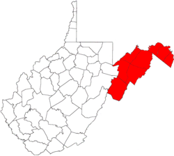
West Virginia's 2nd congressional district consists of the northern half of the state. It contains Barbour, Berkeley, Brooke, Doddridge, Grant, Hampshire, Hancock, Hardy, Harrison, Jefferson, Lewis, Marion, Marshall, Mineral, Monongalia, Morgan, Ohio, Pleasants, Preston, Randolph, Ritchie, Taylor, Tucker, Tyler, Upshur, Wetzel, and Wood counties.

<span class="mw-page-title-main">Andrew Hunter (lawyer)</span> American lawyer (1804–1888)

Andrew H. Hunter was a Virginia lawyer, slaveholder, and politician who served in both houses of the Virginia General Assembly, including the Confederate House of Delegates. He was the Commonwealth's attorney for Jefferson County, Virginia, who prosecuted John Brown for the raid on Harpers Ferry.

The Hagerstown–Martinsburg Metropolitan Area, officially designated by the United States Office of Management and Budget (OMB) as Hagerstown–Martinsburg, Maryland–West Virginia Metropolitan Statistical Area (MSA), constitutes the primary cities of Hagerstown, Maryland; Martinsburg, West Virginia; and surrounding areas in three counties: Washington County, Maryland; Berkeley County, West Virginia; and Morgan County, West Virginia. The metro area lies mainly within the rich, fertile Cumberland and Shenandoah valleys, and is approximately a 60–90 minute drive from Washington, D.C.; Baltimore, Maryland; and Harrisburg, Pennsylvania; Hagerstown is approximately 75 miles (121 km) driving distance from all three cities. The population of the metropolitan area as of 2008 is 263,753.

Philip Clayton Pendleton was a Virginia attorney, planter, politician and jurist. He briefly served as a United States district judge of the United States District Court for the Western District of Virginia. He previously served in the Virginia House of Delegates and as a Virginia state judge.

<span class="mw-page-title-main">History of slavery in West Virginia</span>

The western part of Virginia which became West Virginia was settled in two directions, north to south from Pennsylvania, Maryland and New Jersey and from east to west from eastern Virginia and North Carolina. The earliest arrival of enslaved people was in the counties of the Shenandoah Valley, where prominent Virginia families built houses and plantations. The earliest recorded slave presence was about 1748 in Hampshire County on the estate of Thomas Fairfax, 6th Lord Fairfax of Cameron, which included 150 enslaved people. By the early 19th century, slavery had spread to the Ohio River up to the northern panhandle.

<span class="mw-page-title-main">West Virginia's 16th Senate district</span> American legislative district

West Virginia's 16th Senate district is one of 17 districts in the West Virginia Senate. It is currently represented by Democrat Hannah Geffert and Republican Patricia Rucker. All districts in the West Virginia Senate elect two members to staggered four-year terms.

References

  1. "United States Summary: 2010, Population and Housing Unit Counts, 2010 Census of Population and Housing" (PDF). United States Census Bureau. September 2012. pp. V–2, 1 & 41 (Tables 1 & 18). Archived (PDF) from the original on October 19, 2012. Retrieved February 7, 2014.
  2. "Population, Population Change, and Estimated Components of Population Change: April 1, 2010 to July 1, 2019 (NST-EST2019-alldata)". Census.gov. United States Census Bureau. Archived from the original on January 26, 2020. Retrieved February 8, 2020.
  3. "WV Dept. of Commerce". Archived from the original on November 27, 2015. Retrieved October 29, 2015.
  4. Jenni Vincent (January 25, 2011). "Secession bill planned to 'stir pot'". The Journal . Archived from the original on February 11, 2015. Retrieved February 10, 2015.
  5. "Eastern Panhandle Modern Map". The West Virginia Encyclopedia. West Virginia Humanities Council. Archived from the original on January 28, 2015. Retrieved January 24, 2015.
  6. Williams, B.H.; Fridley, H.M (1923). Soil Survey of Hardy and Pendleton Counties, West Virginia. United States Department of Agriculture . Retrieved January 24, 2015.
  7. "Eastern Panhandle". The West Virginia Encyclopedia. West Virginia Humanities Council. November 20, 2010. Archived from the original on January 28, 2015. Retrieved January 24, 2015.
  8. "Martinsburg (city), West Virginia". State and County QuickFacts. United States Census Bureau. December 4, 2014. Archived from the original on March 27, 2015. Retrieved January 24, 2015.

39°10′N78°35′W / 39.167°N 78.583°W / 39.167; -78.583