
The Allegheny Mountain Range — also spelled Alleghany or Allegany, less formally the Alleghenies — is part of the vast Appalachian Mountain Range of the Eastern United States and Canada. Historically it represented a significant barrier to westward land travel and development. The Alleghenies have a northeast–southwest orientation, running for about 300 miles (480 km) from north-central Pennsylvania southward, through western Maryland and eastern West Virginia.
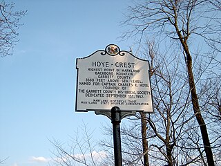
Backbone Mountain is a ridge of the Allegheny Mountains of the central Appalachian Mountain Range. It is situated in the U.S. states of West Virginia and Maryland and forms a portion of the Eastern Continental Divide. Within the state of Maryland, Backbone Mountain reaches an elevation of 3,360 feet or 1,024 metres, making it Maryland's highest point.

The Monongahela National Forest is a national forest located in the Allegheny Mountains of eastern West Virginia, US. It protects over 921,000 acres of federally managed land within a 1,700,000 acres proclamation boundary that includes much of the Potomac Highlands Region and portions of 10 counties.

The Allegheny Front is the major southeast- or east-facing escarpment in the Allegheny Mountains in southern Pennsylvania, western Maryland, eastern West Virginia, and western Virginia. The Allegheny Front forms the boundary between the Ridge-and-Valley Appalachians to its east and the Appalachian Plateau to its west. The Front is closely associated with the Appalachian Mountains' Eastern Continental Divide, which in this area divides the waters of the Ohio/Mississippi river system, flowing to the Gulf of Mexico, from rivers flowing into Chesapeake Bay and from there into the Atlantic Ocean.

The Dolly Sods Wilderness is a U.S. Wilderness Area in the Allegheny Mountains of eastern West Virginia and is part of the Monongahela National Forest of the U.S. Forest Service.

Shavers Fork Mountain Complex is the name given to the mountains on either side of Shavers Fork in the highlands portions of Randolph County, Pocahontas County, and Tucker County in West Virginia, USA. Much of the land surrounding the river and its adjacent mountains is protected by Monongahela National Forest including about 20,000 acres (81 km2) of designated wilderness.
The environment of West Virginia encompasses terrain and ecosystems ranging from plateaus to mountains. Most of West Virginia lies within the Appalachian mixed mesophytic forests ecoregion, while the higher elevations along the eastern border and in the panhandle lie within the Appalachian-Blue Ridge forests.

The Appalachian mixed mesophytic forests is an ecoregion of the temperate broadleaf and mixed forests biome, as defined by the World Wildlife Fund. It consists of mesophytic plants west of the Appalachian Mountains in the Southeastern United States.

Blackwater Falls State Park is located in the Allegheny Mountains of Tucker County, West Virginia, US. The centerpiece of the park is Blackwater Falls, a 62-foot (19 m) cascade where the Blackwater River leaves its leisurely course in Canaan Valley and enters rugged Blackwater Canyon. It is among the most photographed venues in the state and appears on calendars, stationery, and advertisements. The river is named for its tannin-darkened water.

The Appalachian–Blue Ridge forests are an ecoregion in the Temperate broadleaf and mixed forests Biome, in the Eastern United States. The ecoregion is located in the central and southern Appalachian Mountains, including the Ridge-and-Valley Appalachians and the Blue Ridge Mountains. It covers an area of about 61,500 square miles (159,000 km2) in: northeast Alabama and Georgia, northwest South Carolina, eastern Tennessee, western North Carolina, Virginia, Maryland, and central West Virginia and Pennsylvania; and small extensions into Kentucky, New Jersey, and New York.

North Fork Mountain is a quartzite-capped mountain ridge in the Ridge and Valley physiographic province of the Allegheny Mountains, also known as the High Alleghenies or Potomac Highlands, of eastern West Virginia. Kile Knob, at 4,588 feet, is the mountain's highest point, and Panther Knob and Pike Knob are nearly as high.

Canaan Valley is a large bathtub-shaped upland valley in northeastern Tucker County, West Virginia, USA. Within it are extensive wetlands and the headwaters of the Blackwater River which spills out of the valley at Blackwater Falls. It is a well-known and partially undeveloped scenic attraction and tourist draw. Since 1994, almost 70% of the Valley has become the Canaan Valley National Wildlife Refuge, the nation's 500th National Wildlife Refuge, with Canaan Valley Resort State Park and Blackwater Falls State Park nearby.

Back Allegheny Mountain is a long mountain ridge in eastern West Virginia. It is part of the Shavers Fork Mountain Complex in the Allegheny Range of the Appalachians.

Shavers Mountain, is a high and rugged ridge situated in the Allegheny Mountains of eastern West Virginia. It is about 35 miles (56 km) long, north to south, and several of its peaks exceed 4,000 feet (1,200 m) in elevation. Shavers Mountain is notable for being "bookended", at its northern and southern ends, by two exceptional natural areas: the Otter Creek Wilderness and the Gaudineer Scenic Area, respectively, both of which preserve small stands of old growth forest on the mountain.

Blackwater Canyon is a rugged, heavily wooded, eight-mile (13 km) long gorge carved by the Blackwater River in the Allegheny Mountains of eastern West Virginia, USA. For many years, it has been the object of controversy as environmental activists have contended with industrial interests over its ultimate status.

U.S. Route 33 (US 33) in the U.S. state of West Virginia extends 248 miles (399 km) from the Ohio River at Ravenswood to the Virginia state line atop Shenandoah Mountain west of Harrisonburg, Virginia.

Spruce Mountain, located in eastern West Virginia, is the highest ridge of the Allegheny Mountains. The whale-backed ridge extends for only 16 miles (26 km) from northeast to southwest, but several of its peaks exceed 4,500 feet (1,400 m) in elevation. The summit, Spruce Knob, is the highest Allegheny Mountain point both in the state and the entire range, which spans four states.
The Allegheny Parkway was a proposed 632-mile (1,017 km) scenic highway, intended to extend from Harpers Ferry, West Virginia, to the Cumberland Gap, to be managed by the National Park Service. It was seen as a complementary project to the Skyline Drive and Blue Ridge Parkway on the east side of the Shenandoah Valley. Despite support from the Park Service, authorizing legislation was never passed and it was never built.
The Yew Mountains are a mountain ridge in Southern West Virginia that locally forms the boundary between the Allegheny Plateau to the northwest and the Ridge-and-Valley Appalachians to the southeast. It is part of the Allegheny Mountains, and contains some of the highest peaks in West Virginia. Its highest point is 4,703 feet (1,433 m) at Red Spruce Knob near its northern edge, named for the stand of red spruce at its summit, which is also the highest point of the Highland Scenic Highway, and the ninth highest peak in West Virginia. Other peaks include Black Mountain, Jacox Knob, Briery Knob, and Blue Knob. The Cranberry Wilderness of Monongahela National Forest, and the Yew Mountain Center, are within the range. There is a proposal to create a Birthplace of Rivers National Monument in the area.
