Lewis County, West Virginia

Last updated

Lewis County
Lewis County Courthouse Weston.jpg
Lewis County Courthouse
Seal of Lewis County, West Virginia.png
Map of West Virginia highlighting Lewis County.svg
Location within the U.S. state of West Virginia
West Virginia in United States.svg
West Virginia's location within the U.S.
Coordinates: 39°00′N80°31′W / 39°N 80.51°W / 39; -80.51
CountryFlag of the United States.svg United States
StateFlag of West Virginia.svg  West Virginia
FoundedDecember 18, 1816
Seat Weston
Largest cityWeston
Area
  Total390 sq mi (1,000 km2)
  Land385 sq mi (1,000 km2)
  Water4.8 sq mi (12 km2)  1.2%%
Population
 (2020)
  Total17,033
  Estimate 
(2021)
16,892 Decrease2.svg
  Density44/sq mi (17/km2)
Time zone UTC−5 (Eastern)
  Summer (DST) UTC−4 (EDT)
Congressional district 2nd
Website www.lewiscounty.wv.gov

Lewis County is a county in the U.S. state of West Virginia. As of the 2020 census, the population was 17,033. [1] Its county seat is Weston. [2] The county was formed in 1816 from Harrison County. [3]

Contents

Geography

According to the United States Census Bureau, the county has a total area of 390 square miles (1,000 km2), of which 385 square miles (1,000 km2) is land and 4.8 square miles (12 km2) (1.2%) is water. [4]

In 1863, West Virginia's counties were divided into civil townships, with the intention of encouraging local government. This proved impractical in the heavily rural state, and in 1872 the townships were converted into magisterial districts. [5] Lewis County was initially divided into five townships: Battelle, Jane Lew, Lincoln, Sheridan, and Willey. Between 1870 and 1880, these were renamed "Collins Settlement", "Court House", "Freemans Creek", [lower-roman 1] "Hackers Creek", [lower-roman 2] and "Skin Creek". In the 1990s, Collins Settlement and Court House Districts were consolidated into one district, known as "Courthouse-Collins Settlement"; Hackers Creek and Skin Creek were also consolidated, forming "Hackers Creek-Skin Creek". [6]

Major highways

Adjacent counties

Demographics

Historical population
CensusPop.Note
1820 4,247
1830 6,24147.0%
1840 8,15130.6%
1850 10,03123.1%
1860 7,999−20.3%
1870 10,17527.2%
1880 13,26930.4%
1890 15,89519.8%
1900 16,9806.8%
1910 18,82110.8%
1920 20,4558.7%
1930 21,7946.5%
1940 22,2712.2%
1950 21,074−5.4%
1960 19,711−6.5%
1970 17,847−9.5%
1980 18,8135.4%
1990 17,223−8.5%
2000 16,919−1.8%
2010 16,372−3.2%
2020 17,0334.0%
2021 (est.)16,892 [7] −0.8%
U.S. Decennial Census [8]
1790–1960 [9] 1900–1990 [10]
1990–2000 [11] 2010–2020 [1]

2020 census

As of the 2020 census, there were 17,033 people and 6,662 households residing in the county. There were 8,204 housing units in Lewis County. The racial makeup of the city was 94.5% White, 0.4% African American, 0.3% Asian, 0.1% Native American, 0.3% from other races, and 3.9% from two or more races. Hispanics or Latinos of any race were 1.1% of the population.

There were 26,143 households, of which 48.6% were married couples living together, 24.7% had a female householder with no spouse present, 20.8% had a male householder with no spouse present. The average household and family size was 3.13. The median age in the city was 43.6 years with 21.2% of the population was under 18. The median income for a household in the city was $45,345 and the poverty rate was 17.2%. [12]

2010 census

As of the 2010 United States census, there were 16,372 people, 6,863 households, and 4,570 families living in the county. [13] The population density was 42.5 inhabitants per square mile (16.4/km2). There were 7,958 housing units at an average density of 20.7 units per square mile (8.0 units/km2). [14] The racial makeup of the county was 97.9% white, 0.5% black or African American, 0.3% Asian, 0.2% American Indian, 0.1% from other races, and 1.0% from two or more races. Those of Hispanic or Latino origin made up 0.6% of the population. [13] In terms of ancestry, 17.5% were American, 15.0% were German, 9.9% were Irish, and 7.2% were English. [15]

Of the 6,863 households, 28.1% had children under the age of 18 living with them, 50.9% were married couples living together, 10.9% had a female householder with no husband present, 33.4% were non-families, and 28.5% of all households were made up of individuals. The average household size was 2.35 and the average family size was 2.84. The median age was 43.4 years. [13]

The median income for a household in the county was $33,293 and the median income for a family was $42,281. Males had a median income of $31,950 versus $25,945 for females. The per capita income for the county was $18,240. About 13.6% of families and 19.6% of the population were below the poverty line, including 25.3% of those under age 18 and 12.9% of those age 65 or over. [16]

2000 census

As of the census of 2000, there were 16,919 people, 6,946 households, and 4,806 families living in the county. The population density was 44 people per square mile (17 people/km2). There were 7,944 housing units at an average density of 21 units per square mile (8.1 units/km2). The racial makeup of the county was 98.59% White, 0.13% Black or African American, 0.20% Native American, 0.29% Asian, 0.08% from other races, and 0.70% from two or more races. 0.50% of the population were Hispanic or Latino of any race.

There were 6,946 households, out of which 28.60% had children under the age of 18 living with them, 54.60% were married couples living together, 10.50% had a female householder with no husband present, and 30.80% were non-families. 26.90% of all households were made up of individuals, and 13.00% had someone living alone who was 65 years of age or older. The average household size was 2.40 and the average family size was 2.88.

In the county, the population was spread out, with 22.10% under the age of 18, 7.70% from 18 to 24, 28.00% from 25 to 44, 25.90% from 45 to 64, and 16.40% who were 65 years of age or older. The median age was 40 years. For every 100 females there were 94.20 males. For every 100 females age 18 and over, there were 91.40 males.

The median income for a household in the county was $27,066, and the median income for a family was $32,431. Males had a median income of $27,906 versus $18,733 for females. The per capita income for the county was $13,933. 19.90% of the population and 16.30% of families were below the poverty line. 27.00% of those under the age of 18 and 11.20% of those 65 and older were living below the poverty line.

Politics

United States presidential election results for Lewis County, West Virginia [17]
Year Republican Democratic Third party
No.%No.%No.%
2020 5,78277.52%1,53820.62%1391.86%
2016 5,27476.04%1,34719.42%3154.54%
2012 4,37569.51%1,73627.58%1832.91%
2008 4,33565.60%2,10931.92%1642.48%
2004 4,44563.51%2,47535.36%791.13%
2000 3,60658.79%2,35538.39%1732.82%
1996 2,28537.02%2,86846.46%1,02016.52%
1992 2,41336.77%2,93144.66%1,21918.57%
1988 3,60252.14%3,27247.37%340.49%
1984 5,29765.96%2,69333.53%410.51%
1980 3,74749.23%3,45545.39%4095.37%
1976 3,73648.54%3,96051.46%00.00%
1972 5,77873.70%2,06226.30%00.00%
1968 4,02751.40%3,16840.43%6408.17%
1964 2,97936.21%5,24863.79%00.00%
1960 5,15758.56%3,64941.44%00.00%
1956 6,20366.01%3,19433.99%00.00%
1952 6,25465.60%3,28034.40%00.00%
1948 4,82957.89%3,47741.69%350.42%
1944 4,98459.80%3,35040.20%00.00%
1940 5,93556.52%4,56643.48%00.00%
1936 5,49949.61%5,53149.90%540.49%
1932 4,70445.31%5,54653.42%1311.26%
1928 5,29057.37%3,82541.48%1061.15%
1924 4,83951.10%4,41046.57%2212.33%
1920 4,61857.14%3,31040.96%1541.91%
1916 2,26349.06%2,24848.73%1022.21%
1912 1,02924.21%1,92945.39%1,29230.40%

Communities

City

Town

Magisterial districts

Unincorporated communities

See also

Footnotes

  1. Originally spelled "Freeman's Creek".
  2. Originally spelled "Hacker's Creek".

Related Research Articles

<span class="mw-page-title-main">Randolph County, Alabama</span> County in Alabama, United States

Randolph County is a county on the central eastern border of the U.S. state of Alabama. As of the 2020 census, the population was 21,967. Its county seat is Wedowee. Its name is in honor of John Randolph, a member of the United States Senate from Virginia. Randolph County was a prohibition or dry county until 2012, when the citizens of Randolph County voted to repeal prohibition.

<span class="mw-page-title-main">Tallapoosa County, Alabama</span> County in Alabama, United States

Tallapoosa County is located in the east-central portion of the U.S. state of Alabama. As of the 2020 census, the population was 41,311. Its county seat is Dadeville. Its largest city is Alexander City.

<span class="mw-page-title-main">Braxton County, West Virginia</span> County in West Virginia, United States

Braxton County is a county in the central part of the U.S. state of West Virginia. As of the 2020 census, the population was 12,447. The county seat is Sutton. The county was formed in 1836 from parts of Lewis, Kanawha, and Nicholas counties and named for Carter Braxton, a Virginia statesman and signer of the Declaration of Independence.

<span class="mw-page-title-main">Wyoming County, West Virginia</span> County in West Virginia, United States

Wyoming County is a county in the U.S. state of West Virginia. As of the 2020 census, the population was 21,382. Its county seat is Pineville. The county was created in 1850 from Logan County and named for the Lenape word meaning "large plains".

<span class="mw-page-title-main">Wood County, West Virginia</span> County in West Virginia, United States

Wood County is a county in the U.S. state of West Virginia. As of the 2020 census, the population was 84,296, making it West Virginia's fifth-most populous county. Its county seat is Parkersburg. The county was formed in 1798 from the western part of Harrison County and named for James Wood, governor of Virginia from 1796 to 1799.

<span class="mw-page-title-main">Wirt County, West Virginia</span> County in West Virginia, United States

Wirt County is a county in the U.S. state of West Virginia. As of the 2020 census, the population was 5,194, making it the least populous county in West Virginia. Its county seat is Elizabeth. The county was created in 1848 by the Virginia General Assembly and named for U.S. Attorney General and presidential candidate William Wirt. The county is served by one high school, Wirt County High School.

<span class="mw-page-title-main">Webster County, West Virginia</span> County in West Virginia, United States

Webster County is a county in the U.S. state of West Virginia. As of the 2020 census, the population was 8,378. Its county seat is Webster Springs. The county was founded in 1860 and named for Daniel Webster.
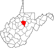
<span class="mw-page-title-main">Taylor County, West Virginia</span> County in West Virginia, United States

Taylor County is a county in the U.S. state of West Virginia. As of the 2020 census, the population was 16,705. Its county seat is Grafton. The county was formed in 1844 and named for Senator John Taylor of Caroline.

<span class="mw-page-title-main">Nicholas County, West Virginia</span> County in West Virginia, United States

Nicholas County is a county located in the central region of U.S. state of West Virginia. As of the 2020 census, the population was 24,604. Its county seat is Summersville. The county was created in 1818 by the Virginia General Assembly and named for Virginia Governor Wilson Cary Nicholas.

<span class="mw-page-title-main">Logan County, West Virginia</span> County in West Virginia, United States

Logan County is a county in the U.S. state of West Virginia. As of the 2020 census, the population was 32,567. Its county seat is Logan. Logan County comprises the Logan, WV Micropolitan Statistical Area, which is also included in the Charleston–Huntington–Ashland, WV–OH–KY Combined Statistical Area.

<span class="mw-page-title-main">Lincoln County, West Virginia</span> County in West Virginia, United States

Lincoln County is a county in the U.S. state of West Virginia. As of the 2020 census, the population was 20,463. Its county seat is Hamlin. The county was created in 1867 and named for Abraham Lincoln.

<span class="mw-page-title-main">Preble County, Ohio</span> County in Ohio, United States

Preble County is a county located in the U.S. state of Ohio. As of the 2020 census, the population was 40,999, down 3.0% from the 2010 census population of 42,270. Its county seat is Eaton. The county was formed on February 15, 1808, from portions of Butler and Montgomery Counties. It is named for Edward Preble, a naval officer who fought in the American Revolutionary War and against the Barbary Pirates.

<span class="mw-page-title-main">Prentiss County, Mississippi</span> County in Mississippi, United States

Prentiss County is a county located in the U.S. state of Mississippi. As of the 2020 census, the population was 25,008. Its county seat is Booneville. The county is named for Seargent Smith Prentiss, a noted speaker and US Congressman from Natchez.

<span class="mw-page-title-main">Webster County, Georgia</span> County in Georgia, United States

Webster County is a county located in the west central portion of the U.S. state of Georgia. As of the 2020 Census reflected a population of 2,348, making it the third-least populous county in Georgia. The county seat is Preston.

<span class="mw-page-title-main">Miller County, Georgia</span> County in Georgia, United States

Miller County is a county located in the southwestern part of the U.S. state of Georgia. As of the 2020 census, the population was 6,000. The county seat is Colquitt. The county was created on February 26, 1856, and named after Andrew Jackson Miller (1806–56), president of the Medical College of Georgia.

<span class="mw-page-title-main">Ridgeway, Virginia</span> Town in Virginia, United States

Ridgeway is a town in Henry County, Virginia, United States. The population was 742 at the 2010 census. It is part of the Martinsville Micropolitan Statistical Area. Martinsville Speedway, a NASCAR racetrack, is located between Ridgeway and the Martinsville city limits.

<span class="mw-page-title-main">Lost Creek, West Virginia</span> Town in West Virginia, United States

Lost Creek is a town in Harrison County, West Virginia, United States. The population was 361 at the 2020 census.

<span class="mw-page-title-main">Jane Lew, West Virginia</span> Town in West Virginia, United States

Jane Lew is a town in Lewis County, West Virginia, United States. The population was 409 at the time of the 2020 census.

<span class="mw-page-title-main">Man, West Virginia</span> Town in West Virginia, United States

Man is a town in Logan County, West Virginia, United States. The population was 759 at the 2010 census. The town is located along the Guyandotte River at the mouth of Buffalo Creek, which was the site of the 1972 Buffalo Creek Flood following a dam collapse. The name of the town reportedly derives from the last syllable of the surname of Ulysses Hinchman, who was a member of the House of Delegates from Logan County between 1866 and 1869.

<span class="mw-page-title-main">Peterstown, West Virginia</span> Town in West Virginia, United States

Peterstown is a town in Monroe County, West Virginia, United States. The population was 456 at the 2020 census.

References

  1. 1 2 "State & County QuickFacts". United States Census Bureau. Retrieved August 14, 2022.
  2. "Find a County". National Association of Counties. Retrieved June 7, 2011.
  3. "West Virginia Counties". www.wvculture.org. Retrieved March 27, 2018.
  4. "2010 Census Gazetteer Files". United States Census Bureau. August 22, 2012. Retrieved July 24, 2015.
  5. Otis K. Rice & Stephen W. Brown, West Virginia: A History, 2nd ed., University Press of Kentucky, Lexington (1993), p. 240.
  6. United States Census Bureau, U.S. Decennial Census, Tables of Minor Civil Divisions in West Virginia, 1870–2010.
  7. "Annual Estimates of the Resident Population for Counties: April 1, 2020 to July 1, 2021" . Retrieved August 14, 2022.
  8. "U.S. Decennial Census". United States Census Bureau. Retrieved January 10, 2014.
  9. "Historical Census Browser". University of Virginia Library. Retrieved January 10, 2014.
  10. "Population of Counties by Decennial Census: 1900 to 1990". United States Census Bureau. Retrieved January 10, 2014.
  11. "Census 2000 PHC-T-4. Ranking Tables for Counties: 1990 and 2000" (PDF). United States Census Bureau. Archived (PDF) from the original on October 9, 2022. Retrieved January 10, 2014.
  12. "Explore Census Data". data.census.gov. Retrieved March 1, 2023.
  13. 1 2 3 "DP-1 Profile of General Population and Housing Characteristics: 2010 Demographic Profile Data". United States Census Bureau. Archived from the original on February 13, 2020. Retrieved April 3, 2016.
  14. "Population, Housing Units, Area, and Density: 2010 - County". United States Census Bureau. Archived from the original on February 13, 2020. Retrieved April 3, 2016.
  15. "DP02 SELECTED SOCIAL CHARACTERISTICS IN THE UNITED STATES – 2006-2010 American Community Survey 5-Year Estimates". United States Census Bureau. Archived from the original on February 13, 2020. Retrieved April 3, 2016.
  16. "DP03 SELECTED ECONOMIC CHARACTERISTICS – 2006-2010 American Community Survey 5-Year Estimates". United States Census Bureau. Archived from the original on February 13, 2020. Retrieved April 3, 2016.
  17. Leip, David. "Dave Leip's Atlas of U.S. Presidential Elections". uselectionatlas.org. Retrieved March 27, 2018.

39°00′N80°31′W / 39.00°N 80.51°W / 39.00; -80.51