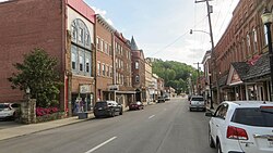
Weston, West Virginia

Last updated

Weston, West Virginia
Main Avenue, Weston, West Virginia (2019).jpg
Main Avenue
Lewis County West Virginia Incorporated and Unincorporated areas Weston Highlighted.svg
Location of Weston in Lewis County, West Virginia.
Coordinates: 39°2′31″N80°28′12″W / 39.04194°N 80.47000°W / 39.04194; -80.47000
Country United States
State West Virginia
County Lewis
Incorporated1818 (town)
1913 (city)
Government
  MayorKim Harrison
Area
[1]
  Total1.99 sq mi (5.16 km2)
  Land1.94 sq mi (5.03 km2)
  Water0.05 sq mi (0.13 km2)
Elevation
1,020 ft (311 m)
Population
 (2020) [2]
  Total3,952
  Estimate 
(2021) [2]
3,890
  Density1,984.05/sq mi (766.11/km2)
Time zone UTC-5 (Eastern (EST))
  Summer (DST) UTC-4 (EDT)
ZIP code
26452
Area code 304
FIPS code 54-85972 [3]
GNIS feature ID1548967 [4]
Website www.cityofwestonwv.com

Weston is a city in and the county seat of Lewis County, West Virginia, United States. [5] The population was 3,943 at the 2020 census. [2] It is home to the Museum of American Glass in West Virginia and the Trans-Allegheny Lunatic Asylum.

Contents

History

Weston was founded in 1818 as Preston; the name was changed to Fleshersville soon after, and then to Weston in 1819. [6] The city was incorporated in 1846. [7]

Weston is the site of the former Trans-Allegheny Lunatic Asylum, a psychiatric hospital and National Historic Landmark which has been mostly vacant since its closure in 1994 upon its replacement by the nearby William R. Sharpe Jr. Hospital. Jackson's Mill, a childhood home of Stonewall Jackson, is approximately four miles (6 km) north of Weston; it has been operated as a 4-H facility since the 1920s and is also the site of conference center operated by the West Virginia University Extension Service. [8] It is listed on the National Register of Historic Places as the Jackson's Mill State 4-H Camp Historic District. [9]

Weston has two national historic districts: the Weston Downtown Historic District and Weston Downtown Residential Historic District. Other buildings on the National Register of Historic Places are the Jonathan M. Bennett House and the former Weston Colored School. [9]

Geography

Weston is located 15 miles (24 km) west of Buckhannon and 20 miles (32 km) south of Clarksburg at 39°2′31″N80°28′12″W / 39.04194°N 80.47000°W / 39.04194; -80.47000 (39.041857, -80.469929), [10] along the West Fork River at its confluence with Stonecoal Creek in North Central West Virginia. [11]

According to the United States Census Bureau, the city has a total area of 2.00 square miles (5.18 km2), of which 1.95 square miles (5.05 km2) are land and 0.05 square miles (0.13 km2) are water. [12]

The city is crossed by Interstate 79, U.S. Route 19, U.S. Route 33 and U.S. Route 119.

Climate

The climate in this area is characterized by hot, humid summers and generally mild to cool winters. According to the Köppen Climate Classification system, Weston has a humid subtropical climate, abbreviated "Cfa" on climate maps. [13]

Demographics

Historical population
CensusPop.Note
1860 820
1870 1,11135.5%
1880 1,51636.5%
1890 2,14341.4%
1900 2,56019.5%
1910 2,213−13.6%
1920 5,701157.6%
1930 8,64651.7%
1940 8,268−4.4%
1950 8,9458.2%
1960 8,754−2.1%
1970 7,323−16.3%
1980 6,250−14.7%
1990 4,994−20.1%
2000 4,317−13.6%
2010 4,110−4.8%
2020 3,952−3.8%
2021 (est.)3,890 [2] −1.6%
U.S. Decennial Census [14]

2020 census

As of the 2020 census, there were 3,952 people and 1,561 households residing in the city. There were 2,106 housing units in Weston. The racial makeup of the city was 93% White, 0.9% African American, 0.9% Asian, 0.1% Native American, 0.8% from other races, and 4.2% from two or more races. Hispanics or Latinos of any race were 1.8% of the population.

There were 1,561 households, of which 34.2% were married couples living together, 32.2% had a female householder with no spouse present, 23.7% had a male householder with no spouse present. The average household and family size was 3.33. The median age in the city was 39.7 years. [15]

2010 census

As of the census [16] of 2010, there were 4,110 people, 1,811 households, and 1,082 families living in the city. The population density was 2,107.7 inhabitants per square mile (813.8/km2). There were 2,135 housing units at an average density of 1,094.9 per square mile (422.7/km2). The racial makeup of the city was 97.0% White, 0.8% African American, 0.7% Asian, and 1.5% from two or more races. Hispanic or Latino of any race were 1.3% of the population.

There were 1,811 households, of which 27.7% had children under the age of 18 living with them, 40.9% were married couples living together, 13.3% had a female householder with no husband present, 5.5% had a male householder with no wife present, and 40.3% were non-families. 33.7% of all households were made up of individuals, and 16.6% had someone living alone who was 65 years of age or older. The average household size was 2.27 and the average family size was 2.86.

The median age in the city was 41.4 years. 22% of residents were under the age of 18; 7.7% were between the ages of 18 and 24; 26.1% were from 25 to 44; 26.2% were from 45 to 64; and 18.1% were 65 years of age or older. The gender makeup of the city was 48.7% male and 51.3% female.
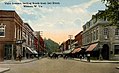
2000 census

As of the census [3] of 2000, there were 4,317 people, 1,942 households, and 1,172 families living in the city. The population density was 2,533.5 inhabitants per square mile (980.5/km2). There were 2,222 housing units at an average density of 1,304.0 per square mile (504.7/km2). The racial makeup of the city was 98.24% White, 0.19% African American, 0.09% Native American, 0.72% Asian, 0.19% from other races, and 0.58% from two or more races. Hispanic or Latino of any race were 0.46% of the population.

There were 1,942 households, out of which 24.5% had children under the age of 18 living with them, 44.4% were married couples living together, 13.2% had a female householder with no husband present, and 39.6% were non-families. 34.7% of all households were made up of individuals, and 18.6% had someone living alone who was 65 years of age or older. The average household size was 2.22 and the average family size was 2.84.

In the city, the population was spread out, with 20.3% under the age of 18, 7.9% from 18 to 24, 27.1% from 25 to 44, 24.9% from 45 to 64, and 19.7% who were 65 years of age or older. The median age was 42 years. For every 100 females, there were 83.2 males. For every 100 females age 18 and over, there were 80.4 males.

The median income for a household in the city was $26,690, and the median income for a family was $33,783. Males had a median income of $27,988 versus $17,335 for females. The per capita income for the city was $14,089. About 15.1% of families and 18.8% of the population were below the poverty line, including 25.8% of those under age 18 and 9.3% of those age 65 or over.

Notable people

West Fork River - former state hospital in background Weston wv west fork river.jpg
West Fork River - former state hospital in background

Related Research Articles

<span class="mw-page-title-main">Wellsburg, West Virginia</span> City in West Virginia, United States

Wellsburg is a city in and the county seat of Brooke County, West Virginia, United States. The 2020 census recorded a population of 2,455. It is a part of the Weirton–Steubenville metropolitan area. The city's economy includes several telemarketing facilities, and a factory that does metal fabrication and plastics molding.

<span class="mw-page-title-main">Lewis County, West Virginia</span> County in West Virginia, United States

Lewis County is a county in the U.S. state of West Virginia. As of the 2020 census, the population was 17,033. Its county seat is Weston. The county was formed in 1816 from Harrison County.

<span class="mw-page-title-main">Weston, Missouri</span> Town in Missouri, United States

Weston is a town in Platte County, Missouri within the United States. The population was 1,756 at the 2020 census.

<span class="mw-page-title-main">Belington, West Virginia</span> City in West Virginia

Belington is a town in Barbour County, West Virginia, United States, situated along the Tygart Valley River. The population was 1,804 as of the 2020 census.

<span class="mw-page-title-main">Madison, West Virginia</span> City in West Virginia, United States

Madison is a city and former coal town in Boone County, West Virginia, United States. The population was 2,911 at the 2020 census. It is the county seat of Boone County.

<span class="mw-page-title-main">Sutton, West Virginia</span> Town in West Virginia

Sutton is a town in Braxton County, West Virginia, United States. The population was 876 at the 2020 census. It is the county seat of Braxton County. Sutton is situated at a center of transportation in West Virginia. Interstate 79, a major north–south route, connects with Appalachian Corridor L, another significant north–south route, passes several miles south of town.

<span class="mw-page-title-main">Bethany, West Virginia</span> Town in West Virginia, United States

Bethany is a town in southern Brooke County, West Virginia, United States. The population was 756 at the 2020 census. It is part of the Weirton–Steubenville metropolitan area. It is best known as the home of Bethany College, a private liberal arts college that was the first institution of higher education in what is now West Virginia.

<span class="mw-page-title-main">Mount Hope, West Virginia</span> City in West Virginia, United States

Mount Hope is a city in Fayette County, West Virginia, United States. The population was 1,414 at the 2010 census.

<span class="mw-page-title-main">Pratt, West Virginia</span> Town in West Virginia, United States

Pratt is a town in Kanawha County, West Virginia, United States, along the Kanawha River. The population was 482 at the 2020 census.

<span class="mw-page-title-main">Logan, West Virginia</span> City in West Virginia, United States

Logan is a city in Logan County, West Virginia, United States, along the Guyandotte River. The population was 1,438 at the 2020 census. It is the county seat of Logan County.

<span class="mw-page-title-main">Cameron, West Virginia</span> City in West Virginia

Cameron is a city in Marshall County, West Virginia, United States. It is part of the Wheeling metropolitan area. The population was 849 at the 2020 census.

<span class="mw-page-title-main">McMechen, West Virginia</span> City in West Virginia

McMechen is a city in Marshall County, West Virginia, United States, situated along the Ohio River. It is part of the Wheeling, West Virginia Metropolitan Statistical Area. The population was 1,714 at the 2020 census.

<span class="mw-page-title-main">Moundsville, West Virginia</span> City in West Virginia, United States

Moundsville is a city in and the county seat of Marshall County, West Virginia, United States, along the Ohio River. The population was 8,122 at the 2020 census. It is part of the Wheeling metropolitan area. The city was named for the nearby ancient Grave Creek Mound, constructed 250 to 100 BC by indigenous people of the Adena culture.

<span class="mw-page-title-main">War, West Virginia</span> City in West Virginia, United States

War is a city in McDowell County, West Virginia, United States. The population was 690 at the 2020 census. War was incorporated in 1920 by the Circuit Court of McDowell County. Its name is derived from War Creek, whose confluence with Dry Fork is located within the city. War is the only place in the United States with this name. War was formerly known as Miner's City. It is also known for being a setting in the movie October Sky; as writer Homer Hickam's Big Creek High School.

<span class="mw-page-title-main">Union, West Virginia</span> Town in West Virginia, United States

Union is a town in Monroe County, West Virginia, United States. Union’s population is 427 as of 2020. It is the county seat of Monroe County.

<span class="mw-page-title-main">Belmont, West Virginia</span> Town in West Virginia, United States

Belmont is a town in Pleasants County, West Virginia, United States. It is part of the Parkersburg–Vienna metropolitan area. The population was 872 at the 2020 census. Belmont was incorporated on April 19, 1946 by the Circuit Court of Pleasants County. The city was named for the beautiful hills in the area.

<span class="mw-page-title-main">Albright, West Virginia</span> Town in West Virginia, United States

Albright is a town in central Preston County, West Virginia, United States, along the Cheat River. The population was 260 at the 2020 census. A former coal town, it is part of the Morgantown metropolitan area.

<span class="mw-page-title-main">Brandonville, West Virginia</span> Town in West Virginia, United States

Brandonville is a town in northern Preston County, West Virginia, United States. The population was 136 at the 2020 census. It is part of the Morgantown metropolitan area.

<span class="mw-page-title-main">Pennsboro, West Virginia</span> City in West Virginia, United States

Pennsboro is a city in Ritchie County, West Virginia, United States. The population was 1,050 at the 2020 census. The city is located at the junction of U.S. Route 50 and West Virginia Route 74; the North Bend Rail Trail also passes through the city.

<span class="mw-page-title-main">Oceana, West Virginia</span> Town in West Virginia, United States

Oceana is a town in Wyoming County, West Virginia. The population was 1,462 at the time of the 2020 census. Oceana is the oldest city in Wyoming County and was the county seat until 1907.

References

  1. "2019 U.S. Gazetteer Files". United States Census Bureau. Retrieved August 7, 2020.
  2. 1 2 3 4 "City and Town Population Totals: 2020-2021". Census.gov. US Census Bureau. Retrieved July 3, 2022.
  3. 1 2 "U.S. Census website". United States Census Bureau . Retrieved January 31, 2008.
  4. "US Board on Geographic Names". United States Geological Survey. October 25, 2007. Retrieved January 31, 2008.
  5. "Find a County". National Association of Counties. Retrieved June 7, 2011.
  6. Swick, Gerald D. (2006). "Weston State Hospital". In Ken Sullivan (ed.). The West Virginia Encyclopedia. Charleston, W.Va.: West Virginia Humanities Council. p. 779. ISBN   0-9778498-0-5.
  7. West Virginia Blue Book. Published annually by the Clerk's Office of the West Virginia Senate.
  8. Meador, Michael M. (2006). "Jackson's Mill". In Ken Sullivan (ed.). The West Virginia Encyclopedia. Charleston, WV: West Virginia Humanities Council. pp. 375–376. ISBN   0-9778498-0-5..
  9. 1 2 "National Register Information System". National Register of Historic Places . National Park Service. July 9, 2010.
  10. "US Gazetteer files: 2010, 2000, and 1990". United States Census Bureau. February 12, 2011. Retrieved April 23, 2011.
  11. DeLorme (1997). West Virginia Atlas & Gazetteer. Yarmouth, Maine: DeLorme. p.36. ISBN   0-89933-246-3.
  12. "US Gazetteer files 2010". United States Census Bureau . Retrieved January 24, 2013.
  13. Climate Summary for Weston, West Virginia
  14. "Census of Population and Housing". Census.gov. Retrieved June 4, 2015.
  15. "Explore Census Data". data.census.gov. Retrieved February 23, 2023.
  16. "U.S. Census website". United States Census Bureau . Retrieved January 24, 2013.