Blacksville, West Virginia

Last updated

Blacksville, West Virginia
Blacksville post office 26521.jpg
The community's post office
Monongalia County West Virginia Incorporated and Unincorporated areas Blacksville Highlighted.svg
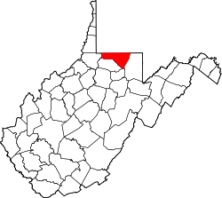
Location of Blacksville in Monongalia County, West Virginia.
Coordinates: 39°43′12″N80°12′45″W / 39.72000°N 80.21250°W / 39.72000; -80.21250
Country Flag of the United States.svg  United States
State Flag of West Virginia.svg  West Virginia
County Flag of Monongalia County, West Virginia.svg Monongalia
Government
  Type Mayor–council government
Area
[1]
  Total0.31 sq mi (0.80 km2)
  Land0.30 sq mi (0.78 km2)
  Water0.01 sq mi (0.02 km2)
Elevation
[2]
984 ft (300 m)
Population
 (2020) [3]
  Total118
  Estimate 
(2021) [3]
120
  Density602.01/sq mi (232.11/km2)
Time zone UTC-5 (Eastern (EST))
  Summer (DST) UTC-4 (EDT)
ZIP code
26521
Area code 304
FIPS code 54-08092 [4]
GNIS feature ID1553918 [2]

Blacksville is an Incorporated Town in Monongalia County, West Virginia, United States. The population was 118 at the 2020 census. [3] It is included in the Morgantown, West Virginia Metropolitan Statistical Area.

Contents

The Town of Blacksville has a C1 Census Class Code which indicates an active incorporated place that does not serve as a county subdivision equivalent. It also has a Functional Status Code of "A" which identifies an active government providing primary general-purpose functions. [5]

History

The Town is named after David Black. [6] A civil engineer from Virginia who came to the area in 1800. Black was eventually able to secure 100 acres of land from Brice Worley for $50. Black then requested a patent in the summer of 1829, to lay out 160 acres of his land and sell plots in a move similar to creating a subdivision today. [7] On February 3, 1830, the General Assembly of Virginia passed an act, establishing the town as a Municipal Corporation and naming it Blacksville. [8] During the American Civil War, Blacksville became an unincorporated community on June 20, 1863. With the creation of the U.S. State of West Virginia, the West Virginia Legislature then re-incorporated the town in October 1897. [7]

Geography

Blacksville is located at 39°43′12″N80°12′45″W / 39.72000°N 80.21250°W / 39.72000; -80.21250 (39.720036, -80.212562). [9]

According to the United States Census Bureau, the town has a total area of 0.31 square miles (0.80 km2), of which 0.30 square miles (0.78 km2) is land and 0.01 square miles (0.03 km2) is water. [10]

Demographics

Historical population
CensusPop.Note
1880 106
1900 180
1910 20413.3%
1920 2186.9%
1930 26923.4%
1940 261−3.0%
1950 241−7.7%
1960 211−12.4%
1970 26425.1%
1980 248−6.1%
1990 168−32.3%
2000 1754.2%
2010 171−2.3%
2020 118−31.0%
2021 (est.)120 [3] 1.7%
U.S. Decennial Census [11]

2010 census

At the 2010 census there were 171 people, 69 households, and 46 families living in the town. The population density was 570.0 inhabitants per square mile (220.1/km2). There were 79 housing units at an average density of 263.3 per square mile (101.7/km2). The racial makeup of the town was 97.1% White and 2.9% from two or more races. [12] Of the 69 households 30.4% had children under the age of 18 living with them, 44.9% were married couples living together, 14.5% had a female householder with no husband present, 7.2% had a male householder with no wife present, and 33.3% were non-families. 24.6% of households were one person and 8.7% were one person aged 65 or older. The average household size was 2.48 and the average family size was 3.00.

The median age in the town was 35.2 years. 25.1% of residents were under the age of 18; 8.2% were between the ages of 18 and 24; 28.1% were from 25 to 44; 26.4% were from 45 to 64; and 12.3% were 65 or older. The gender makeup of the town was 51.5% male and 48.5% female.

2000 census

At the 2000 census there were 175 people, 69 households, and 50 families living in the town. The population density was 576.2 inhabitants per square mile (225.2/km2). There were 84 housing units at an average density of 276.6 per square mile (108.1/km2). The racial makeup of the town was 100.00% White. [4] Of the 69 households 40.6% had children under 18 living with them, 42.0% were married couples living together, 23.2% had a female householder with no husband present, and 27.5% were non-families. 23.2% of households were one person and 14.5% were one person aged 65 or older. The average household size was 2.54 and the average family size was 2.98.

The age distribution was 30.9% under 18, 9.1% from 18 to 24, 26.9% from 25 to 44, 18.9% from 45 to 64, and 14.3% 65 or older. The median age was 34 years. For every 100 females, there were 82.3 males. For every 100 females age 18 and over, there were 75.4 males.

The median household income was $31,250 and the median family income was $36,875. Males had a median income of $29,167 versus $16,667 for females. The per capita income for the town was $13,461. About 12.5% of families and 17.0% of the population were below the poverty line, including 21.7% of those under the age of eighteen and 11.1% of those sixty five or over.

Education

Monongalia County Schools serves Blacksville. [13] Zoned schools include Mason Dixon Elementary School, [14] and Clay-Battelle Middle/High School. [15]

Blacksville pottery

During the mid 20th century, Blacksville was well known for its pottery, made by local residents using native clay. Edgar Richardson (b. Jollytown, PA 1903 - d. 1962) taught pottery at Clay-Battelle high school and his beautiful pieces, signed "E.R. - Blacksville," are still being auctioned and collected. First Lady Eleanor Roosevelt visited Blacksville on June 28, 1938, to learn more about the "Blacksville pottery project." [16]

See also

Related Research Articles

<span class="mw-page-title-main">Wetzel County, West Virginia</span> County in West Virginia, United States

Wetzel County is a county in the U.S. state of West Virginia. As of the 2020 census, the population was 14,442. Its county seat is New Martinsville. The county, founded in 1846, is named for Lewis Wetzel, a famous frontiersman and Indian fighter. Its northern border aligns with the Mason-Dixon line, but is to the west of the line's western terminus.

<span class="mw-page-title-main">Taylor County, West Virginia</span> County in West Virginia, United States

Taylor County is a county in the U.S. state of West Virginia. As of the 2020 census, the population was 16,705. Its county seat is Grafton. The county was formed in 1844 and named for Senator John Taylor of Caroline.

<span class="mw-page-title-main">Nicholas County, West Virginia</span> County in West Virginia, United States

Nicholas County is a county located in the central region of U.S. state of West Virginia. As of the 2020 census, the population was 24,604. Its county seat is Summersville. The county was created in 1818 by the Virginia General Assembly and named for Virginia Governor Wilson Cary Nicholas.

<span class="mw-page-title-main">Monongalia County, West Virginia</span> County in West Virginia, United States

Monongalia County, known locally as Mon County, is located in the U.S. state of West Virginia. As of the 2020 census, the population was 105,822, making it West Virginia's third-most populous county. Its county seat is Morgantown. The county was founded in 1776. Monongalia County is included in the Morgantown, WV Metropolitan Statistical Area, and is the largest county in North-Central West Virginia. It is part of the Pittsburgh media market.

<span class="mw-page-title-main">Marion County, West Virginia</span> County in West Virginia, United States

Marion County is a county in the U.S. state of West Virginia. As of the 2020 census, the population was 56,205. Its county seat is Fairmont. The county was named in honor of General Francis Marion, known to history as "The Swamp Fox".

<span class="mw-page-title-main">Wayne Township, Greene County, Pennsylvania</span> Township in Pennsylvania, United States

Wayne Township is a township that is located in Greene County, Pennsylvania, United States. The population was 1,019 at the time of the 2020 census.

<span class="mw-page-title-main">Clay, West Virginia</span> Town in West Virginia, United States

Clay is a town in and the county seat of Clay County, West Virginia, United States. The population was 399 at the 2020 census. It is the only incorporated town in Clay County.

<span class="mw-page-title-main">New Cumberland, West Virginia</span> City in West Virginia, United States

New Cumberland is a city in and the county seat of Hancock County, West Virginia, United States, along the Ohio River. The population was 1,020 as of the 2020 census. It is part of the Weirton–Steubenville metropolitan area and is located near the Mountaineer Casino, Racetrack and Resort.

<span class="mw-page-title-main">Nutter Fort, West Virginia</span> Town in West Virginia, United States

Nutter Fort is a town in Harrison County, West Virginia, United States, incorporated in 1923. The town is a southeastern suburb of Clarksburg.

<span class="mw-page-title-main">West Hamlin, West Virginia</span> Town in West Virginia, United States

West Hamlin is a town in Lincoln County, West Virginia, United States, along the Guyandotte River. The population was 519 at the 2020 census, and is now down to 509, according to the 2021 census. West Hamlin is a part of the Huntington-Ashland, WV-KY-OH, Metropolitan Statistical Area (MSA). West Hamlin is west of the county seat at Hamlin, hence the name.

<span class="mw-page-title-main">Chapmanville, West Virginia</span> Town in West Virginia, United States

Chapmanville is a town in Logan County, West Virginia, United States. The population was 1,025 at the 2020 census. Chapmanville is named for Ned Chapman, an early settler who operated a store and post office. It was incorporated in 1947.

<span class="mw-page-title-main">Rivesville, West Virginia</span> Town in West Virginia, United States

Rivesville is a town and former coal town in Marion County, West Virginia, United States. The population was 830 at the 2020 census.

<span class="mw-page-title-main">Athens, West Virginia</span> Town in West Virginia, United States

Athens is a town in Mercer County, West Virginia, United States. The population was 944 at the 2020 census. It is part of the Bluefield, WV-VA micropolitan area which has a population of 107,578. Athens is the home of Concord University.

<span class="mw-page-title-main">Elk Garden, West Virginia</span> Town in West Virginia, United States

Elk Garden is a town in Mineral County, West Virginia, United States. It is part of the 'Cumberland, MD-WV Metropolitan Statistical Area'. The population was 211 at the 2020 census. Elk Garden High School was consolidated into Keyser High School in 1997. However the Primary School is still in session, offering classes from Pre-Kindergarten through the fifth grade. The school mascot is the Elk Garden Stags. Elk Garden was incorporated in 1890 by the Mineral County Circuit Court. It is named for an elk lick near the original town site.

<span class="mw-page-title-main">Brookhaven, West Virginia</span> CDP in West Virginia

Brookhaven is a census-designated place (CDP) in Monongalia County, West Virginia, United States. The population was 5,707 at the 2020 census. It is included in the Morgantown, West Virginia Metropolitan Statistical Area.

<span class="mw-page-title-main">Granville, West Virginia</span> Town in West Virginia

Granville is a town in Monongalia County, West Virginia, United States. The population was 1,355 at the 2020 census. It is included in the Morgantown metropolitan area.

<span class="mw-page-title-main">Star City, West Virginia</span> Town in West Virginia

Star City is a town in Monongalia County, West Virginia, United States. The population was 1,779 at the 2020 census. It is included in the Morgantown, West Virginia Metropolitan Statistical Area.

<span class="mw-page-title-main">Westover, West Virginia</span> City in West Virginia

Westover is a city in Monongalia County, West Virginia, United States, along the Monongahela River. The population was 3,995 at the 2020 census. It is part of the Morgantown metropolitan area.

<span class="mw-page-title-main">Flemington, West Virginia</span> Town in West Virginia, United States

Flemington is a town in Taylor County, West Virginia, United States. The population was 311 at the 2020 census. Flemington was incorporated in 1922 by the West Virginia Circuit Court, and named for James Fleming, an early settler in the area originally from Hampshire County.

Clay-Battelle Middle/High School is a secondary school in unincorporated Monongalia County, West Virginia, adjacent to Blacksville. It is operated by Monongalia County Schools.

References

  1. "2019 U.S. Gazetteer Files". United States Census Bureau. Retrieved August 7, 2020.
  2. 1 2 U.S. Geological Survey Geographic Names Information System: Blacksville, West Virginia
  3. 1 2 3 4 "City and Town Population Totals: 2020-2021". Census.gov. US Census Bureau. Retrieved July 3, 2022.
  4. 1 2 "U.S. Census website". United States Census Bureau . Retrieved January 31, 2008.
  5. "Blacksville, WV Profile: Facts & Data". westvirginia.hometownlocator.com. Retrieved September 11, 2022.
  6. Kenny, Hamill (1945). West Virginia Place Names: Their Origin and Meaning, Including the Nomenclature of the Streams and Mountains. Piedmont, WV: The Place Name Press. p. 118.
  7. 1 2 "Blacksville | Greene County Living | observer-reporter.com". observer-reporter.com. Retrieved September 11, 2022.
  8. Geocaching. "Geocaching - The Official Global GPS Cache Hunt Site". www.geocaching.com. Retrieved September 11, 2022.
  9. "US Gazetteer files: 2010, 2000, and 1990". United States Census Bureau. February 12, 2011. Retrieved April 23, 2011.
  10. "US Gazetteer files 2010". United States Census Bureau. Archived from the original on January 25, 2012. Retrieved January 24, 2013.
  11. "Census of Population and Housing". Census.gov. Retrieved June 4, 2015.
  12. "U.S. Census website". United States Census Bureau . Retrieved January 24, 2013.
  13. "2010 CENSUS - CENSUS BLOCK MAP: Blacksville town, WV." U.S. Census Bureau. Retrieved on November 16, 2018.
  14. "Mason Dixon Elementary School Archived 2018-11-16 at the Wayback Machine " - Derived from the Monongalia County School District Mapping program. Monongalia County Schools. Retrieved on November 16, 2018.
  15. "Clay Battelle MS Zone Archived 2018-11-16 at the Wayback Machine " and "Clay Battelle HS Zone Archived 2018-11-16 at the Wayback Machine ." - Derived from the Monongalia County School District Mapping program. Monongalia County Schools. Retrieved on November 16, 2018.
  16. Roosevelt, Eleanor. "June 28, 1938". My Day. Retrieved July 26, 2014.

Commons-logo.svg Media related to Blacksville, West Virginia at Wikimedia Commons