Flemington, West Virginia

Last updated

Flemington, West Virginia
Taylor County West Virginia Incorporated and Unincorporated areas Flemington Highlighted.svg
Location of Flemington in Taylor County, West Virginia.
Coordinates: 39°16′0″N80°7′46″W / 39.26667°N 80.12944°W / 39.26667; -80.12944
Country United States
State West Virginia
County Taylor
Area
[1]
  Total
0.30 sq mi (0.79 km2)
  Land0.30 sq mi (0.79 km2)
  Water0.00 sq mi (0.00 km2)
Elevation
[2]
1,017 ft (310 m)
Population
 (2020) [3]
  Total
311
  Estimate 
(2021) [3]
307
  Density1,003.28/sq mi (387.49/km2)
Time zone UTC-5 (Eastern (EST))
  Summer (DST) UTC-4 (EDT)
ZIP code
26347
Area code 304
FIPS code 54-27940 [4]
GNIS feature ID1554472 [2]
Website https://local.wv.gov/flemington/Pages/default.aspx

Flemington is a town in Taylor County, West Virginia, United States. The population was 311 at the 2020 census. [3] Flemington was incorporated in 1922 by the West Virginia Circuit Court, and named for James Fleming, [5] an early settler in the area originally from Hampshire County. West Virginia College operated here from 1865 to 1895.

Contents

Geography

Flemington is located at 39°16′0″N80°7′46″W / 39.26667°N 80.12944°W / 39.26667; -80.12944 (39.266749, -80.129378), [6] along Simpson Creek. [7]

According to the United States Census Bureau, the town has a total area of 0.31 square miles (0.80 km2), all land. [8]

Demographics

Historical population
CensusPop.Note
1930 617
1940 69011.8%
1950 572−17.1%
1960 478−16.4%
1970 458−4.2%
1980 452−1.3%
1990 352−22.1%
2000 287−18.5%
2010 3128.7%
2020 311−0.3%
2021 (est.)307 [3] −1.3%
U.S. Decennial Census [9]

2010 census

As of the census [10] of 2010, there were 312 people, 124 households, and 90 families living in the town. The population density was 1,006.5 inhabitants per square mile (388.6/km2). There were 139 housing units at an average density of 448.4 per square mile (173.1/km2). The racial makeup of the town was 98.7% White, 0.6% African American, and 0.6% from two or more races. Hispanic or Latino of any race were 2.6% of the population.

There were 124 households, of which 29.0% had children under the age of 18 living with them, 50.0% were married couples living together, 12.1% had a female householder with no husband present, 10.5% had a male householder with no wife present, and 27.4% were non-families. 23.4% of all households were made up of individuals, and 13.7% had someone living alone who was 65 years of age or older. The average household size was 2.52 and the average family size was 2.94.

The median age in the town was 45 years. 21.8% of residents were under the age of 18; 6.1% were between the ages of 18 and 24; 22.1% were from 25 to 44; 29.1% were from 45 to 64; and 20.8% were 65 years of age or older. The gender makeup of the town was 49.4% male and 50.6% female.

2000 census

As of the census [4] of 2000, there were 287 people, 108 households, and 77 families living in the town. The population density was 943.5 inhabitants per square mile (369.4/km2). There were 117 housing units at an average density of 384.7 per square mile (150.6/km2). The racial makeup of the town was 98.26% White, 1.05% African American, 0.35% Native American, and 0.35% from two or more races. Hispanic or Latino of any race were 2.44% of the population.

There were 108 households, out of which 29.6% had children under the age of 18 living with them, 58.3% were married couples living together, 8.3% had a female householder with no husband present, and 28.7% were non-families. 24.1% of all households were made up of individuals, and 14.8% had someone living alone who was 65 years of age or older. The average household size was 2.66 and the average family size was 3.19.

In the town, the population was spread out, with 23.7% under the age of 18, 5.9% from 18 to 24, 27.9% from 25 to 44, 27.5% from 45 to 64, and 15.0% who were 65 years of age or older. The median age was 40 years. For every 100 females, there were 108.0 males. For every 100 females age 18 and over, there were 93.8 males.

The median income for a household in the town was $27,917, and the median income for a family was $40,417. Males had a median income of $32,500 versus $21,563 for females. The per capita income for the town was $12,540. About 22.7% of families and 23.6% of the population were below the poverty line, including 24.1% of those under the age of eighteen and 10.5% of those 65 or over.

Related Research Articles

<span class="mw-page-title-main">Town Creek, Alabama</span> Town in Alabama, United States

Town Creek is a town in Lawrence County, Alabama, United States, and is included in the Decatur Metropolitan Area, as well as the Huntsville-Decatur Combined Statistical Area. It incorporated in March 1875. As of the 2010 census, the population of the town is 1100, down from 1216 in 2000. Since 1920, it has been the second largest town in Lawrence County after Moulton.

<span class="mw-page-title-main">Browning, Illinois</span> Village in Illinois, United States

Browning is a village in Schuyler County, Illinois, United States. The population was 130 at the 2000 census.

<span class="mw-page-title-main">Wallagrass, Maine</span> Town in the state of Maine, United States

Wallagrass is a town in Aroostook County, Maine, United States. The population was 519 at the 2020 census.

<span class="mw-page-title-main">Worth Township, Mercer County, Pennsylvania</span> Township in Pennsylvania, United States

Worth Township is a township in Mercer County, Pennsylvania, United States. The population was 824 at the 2020 census, a decrease from 899 in 2010.

<span class="mw-page-title-main">Junior, West Virginia</span> Town in West Virginia, United States

Junior is a town in Barbour County, West Virginia, United States, situated along the Tygart Valley River. The population was 384 at the 2020 census.

<span class="mw-page-title-main">Flatwoods, West Virginia</span> Town in West Virginia, United States

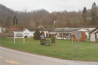
Flatwoods is a town in Braxton County, West Virginia, United States, located approximately one mile from exit 67 of Interstate 79.

<span class="mw-page-title-main">Sand Fork, West Virginia</span> Town in West Virginia, United States

Sand Fork is a town in Gilmer County, West Virginia, United States. The population was 182 at the 2020 census. It is located along the Little Kanawha River, at the mouth of the Sand Fork.

<span class="mw-page-title-main">Quinwood, West Virginia</span> Town in West Virginia, United States

Quinwood is a town and former coal town in Greenbrier County, West Virginia, United States. The population was 220 at the 2020 census.

<span class="mw-page-title-main">West Milford, West Virginia</span> Town in West Virginia, United States

West Milford is a town in Harrison County, West Virginia, United States. The population was 452 at the 2020 census.

<span class="mw-page-title-main">Worthington, West Virginia</span> Town in West Virginia, United States

Worthington is a town in Marion County, West Virginia, United States. The population was 158 at the 2010 census. Worthington was incorporated in 1893 and named for Colonel George Worthington, an early settler. U.S. Route 19 passes through the town.

<span class="mw-page-title-main">Glen Dale, West Virginia</span> Town in West Virginia

Glen Dale is a city in Marshall County, West Virginia, United States, along the Ohio River. It is part of the Wheeling, West Virginia Metropolitan Statistical Area. The population was 1,514 at the 2020 census. Glen Dale was incorporated in 1924. It is in the northwest part of the county, which is above the Mason–Dixon line and forms the base of the Northern Panhandle of West Virginia.

<span class="mw-page-title-main">Leon, West Virginia</span> Town in West Virginia, United States

Leon is a town in Mason County, West Virginia, United States, situated along the Kanawha River. The population was 137 at the 2020 census. It is part of the Point Pleasant, WV–OH Micropolitan Statistical Area.

<span class="mw-page-title-main">Bradshaw, West Virginia</span> Town in West Virginia, United States

Bradshaw is a town in McDowell County, West Virginia, United States. The population was 337 at the 2010 census. Bradshaw was incorporated in December 1979 and named for a pioneer settler.

<span class="mw-page-title-main">Peterstown, West Virginia</span> Town in West Virginia, United States

Peterstown is a town in Monroe County, West Virginia, United States. The population was 456 at the 2020 census.

<span class="mw-page-title-main">Newburg, West Virginia</span> Town in West Virginia, United States

Newburg is a town in western Preston County, West Virginia, United States. The population was 275 at the 2020 census. The town was so named on account of it being the newest town on the railroad, according to local history.

<span class="mw-page-title-main">Harman, West Virginia</span> Town in West Virginia, United States

Harman is a town in Randolph County, West Virginia, United States. The population was 96 at the 2020 census.

<span class="mw-page-title-main">Auburn, West Virginia</span> Town in West Virginia, United States

Auburn is a town in Ritchie County, West Virginia, United States. The population was 80 at the 2020 census.

<span class="mw-page-title-main">Pennsboro, West Virginia</span> City in West Virginia, United States

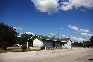
Pennsboro is a city in Ritchie County, West Virginia, United States. The population was 1,050 at the 2020 census. The city is located at the junction of U.S. Route 50 and West Virginia Route 74; the North Bend Rail Trail also passes through the city.

<span class="mw-page-title-main">Pullman, West Virginia</span> Town in West Virginia, United States

Pullman is a town in Ritchie County, West Virginia, United States. The population was 134 at the 2020 census.

<span class="mw-page-title-main">Camden-on-Gauley, West Virginia</span> Town in West Virginia, United States

Camden-on-Gauley is a town in Webster County, West Virginia, United States, along the Gauley River. The population was 126 at the 2020 census.

References

  1. "2019 U.S. Gazetteer Files". United States Census Bureau. Retrieved August 7, 2020.
  2. 1 2 U.S. Geological Survey Geographic Names Information System: Flemington, West Virginia
  3. 1 2 3 4 "City and Town Population Totals: 2020-2021". Census.gov. US Census Bureau. Retrieved July 2, 2022.
  4. 1 2 "U.S. Census website". United States Census Bureau . Retrieved January 31, 2008.
  5. Kenny, Hamill (1945). West Virginia Place Names: Their Origin and Meaning, Including the Nomenclature of the Streams and Mountains. Piedmont, WV: The Place Name Press. p. 244.
  6. "US Gazetteer files: 2010, 2000, and 1990". United States Census Bureau. February 12, 2011. Retrieved April 23, 2011.
  7. DeLorme (1997). West Virginia Atlas & Gazetteer. Yarmouth, Maine: DeLorme. p.36. ISBN   0-89933-246-3.
  8. "US Gazetteer files 2010". United States Census Bureau. Archived from the original on January 25, 2012. Retrieved January 24, 2013.
  9. "Census of Population and Housing". Census.gov. Retrieved June 4, 2015.
  10. "U.S. Census website". United States Census Bureau . Retrieved January 24, 2013.