Lost Creek, West Virginia

Last updated

Lost Creek, West Virginia
LostCreekWVBnODepot.JPG
Lost Creek West Virginia Baltimore and Ohio Railroad Depot
Harrison County West Virginia Incorporated and Unincorporated areas Lost Creek Highlighted.svg
Location of Lost Creek in Harrison County, West Virginia.
Coordinates: 39°9′30″N80°20′53″W / 39.15833°N 80.34806°W / 39.15833; -80.34806
Country United States
State West Virginia
County Harrison
Area
[1]
  Total0.97 sq mi (2.51 km2)
  Land0.97 sq mi (2.51 km2)
  Water0.00 sq mi (0.00 km2)
Elevation
1,020 ft (311 m)
Population
 (2020) [2]
  Total359
  Estimate 
(2021) [2]
357
  Density477.86/sq mi (184.51/km2)
Time zone UTC-5 (Eastern (EST))
  Summer (DST) UTC-4 (EDT)
ZIP code
26385
Area code 304
FIPS code 54-48748 [3]
GNIS feature ID1554998 [4]
Website https://local.wv.gov/lostcreek/Pages/default.aspx

Lost Creek is a town in Harrison County, West Virginia, United States. The population was 359 at the 2020 census. [2]

Contents

History

Lost Creek was incorporated in 1946, and was named after nearby Lost Creek. [5] [6] The creek itself was named after messages carved on nearby trees during early European exploration of the area. [7]

The Daniel Bassel House and Lost Creek Baltimore and Ohio Railroad Depot are listed on the National Register of Historic Places. [8]

Geography

Lost Creek is located at 39°9′30″N80°20′53″W / 39.15833°N 80.34806°W / 39.15833; -80.34806 (39.158451, -80.348165) in southern Harrison County. [9]

According to the United States Census Bureau, the town has a total area of 0.97 square miles (2.51 km2), all of it land. [10]

Demographics

Historical population
CensusPop.Note
1950 798
1960 678−15.0%
1970 571−15.8%
1980 6045.8%
1990 413−31.6%
2000 46713.1%
2010 4966.2%
2020 359−27.6%
2021 (est.)357 [2] −0.6%
U.S. Decennial Census [11]

2020 Census

Lost Creek, West Virginia - Demographic Profile(NH = Non-Hispanic)
Race / EthnicityPop 2020% 2020
White alone (NH)32991.64%
Black or African American alone (NH)10.28%
Native American or Alaska Native alone (NH)00.00%
Asian alone (NH)10.28%
Pacific Islander alone (NH)00.00%
Some Other Race alone (NH)00.00%
Mixed Race/Multi-Racial (NH)71.95%
Hispanic or Latino (any race)215.85%
Total359100.00%

Note: the US Census treats Hispanic/Latino as an ethnic category. This table excludes Latinos from the racial categories and assigns them to a separate category. Hispanics/Latinos can be of any race.

2010 Census

As of the census [12] of 2010, there were 496 people, 185 households, and 139 families living in the town. The population density was 511.3 inhabitants per square mile (197.4/km2). There were 205 housing units at an average density of 211.3 per square mile (81.6/km2). The racial makeup of the town was 95.8% White, 0.8% African American, 0.4% Native American, 0.6% from other races, and 2.4% from two or more races. Hispanic or Latino of any race were 1.8% of the population.

There were 185 households, of which 37.3% had children under the age of 18 living with them, 49.7% were married couples living together, 20.0% had a female householder with no husband present, 5.4% had a male householder with no wife present, and 24.9% were non-families. 18.9% of all households were made up of individuals, and 8.1% had someone living alone who was 65 years of age or older. The average household size was 2.68 and the average family size was 2.97.

The median age in the town was 38.2 years. 27.6% of residents were under the age of 18; 3.6% were between the ages of 18 and 24; 26.3% were from 25 to 44; 28.5% were from 45 to 64; and 14.1% were 65 years of age or older. The gender makeup of the town was 48.2% male and 51.8% female.

2000 Census

As of the census [3] of 2000, there were 467 people, 184 households, and 133 families living in the town. The population density was 461.4 inhabitants per square mile (178.5/km2). There were 207 housing units at an average density of 204.5 per square mile (79.1/km2). The racial makeup of the town was 98.29% White, 0.21% Asian, and 1.50% from two or more races. Hispanic or Latino of any race were 0.43% of the population.

There were 184 households, out of which 27.2% had children under the age of 18 living with them, 52.7% were married couples living together, 15.8% had a female householder with no husband present, and 27.7% were non-families. 24.5% of all households were made up of individuals, and 13.6% had someone living alone who was 65 years of age or older. The average household size was 2.54 and the average family size was 3.00.

In the town, the population was spread out, with 21.8% under the age of 18, 8.8% from 18 to 24, 30.0% from 25 to 44, 23.6% from 45 to 64, and 15.8% who were 65 years of age or older. The median age was 39 years. For every 100 females, there were 91.4 males. For every 100 females age 18 and over, there were 97.3 males.

The median income for a household in the town was $26,563, and the median income for a family was $35,893. Males had a median income of $32,292 versus $19,500 for females. The per capita income for the town was $15,711. About 22.6% of families and 26.0% of the population were below the poverty line, including 36.8% of those under age 18 and 20.5% of those age 65 or over.

Education

Lost Creek is home to Lost Creek Elementary School, South Harrison Middle School, and South Harrison High School. The three schools are part of the Harrison County School District. In 2021, a new Lost Creek Elementary School was constructed adjacent to the South Harrison campus. [13]

Related Research Articles

<span class="mw-page-title-main">Monongalia County, West Virginia</span> County in West Virginia, United States

Monongalia County, known locally as Mon County, is located in the U.S. state of West Virginia. As of the 2020 census, the population was 105,822, making it West Virginia's third-most populous county. Its county seat is Morgantown. The county was founded in 1776. Monongalia County is included in the Morgantown, WV Metropolitan Statistical Area, and is the largest county in North-Central West Virginia. It is part of the Pittsburgh media market.

<span class="mw-page-title-main">Harrison County, West Virginia</span> County in West Virginia, United States

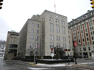
Harrison County is a county in the U.S. state of West Virginia. As of the 2020 census, the population was 65,921. Its county seat is Clarksburg.

<span class="mw-page-title-main">Passaic, Missouri</span> Town in Missouri, United States

Passaic is a town in Bates County, Missouri, and is part of the Kansas City metropolitan area within the United States.

<span class="mw-page-title-main">Gauley Bridge, West Virginia</span> Town in West Virginia, United States

Gauley Bridge is a town in Fayette County, West Virginia, United States. The population was 614 at the 2010 census. The Kanawha River is formed at Gauley Bridge by the confluence of the New and Gauley Rivers. Two miles to the southwest of Gauley Bridge, in Glen Ferris, is Kanawha Falls, a popular stopping point on Midland Trail Scenic Highway.

<span class="mw-page-title-main">Anmoore, West Virginia</span> Town in West Virginia, United States

Anmoore is a town in Harrison County, West Virginia, United States. It is located at the intersection of WV 58 and Interstate 79. The population was 514 at the 2020 census.

<span class="mw-page-title-main">Bridgeport, West Virginia</span> City in West Virginia, United States

Bridgeport is a city in eastern Harrison County, West Virginia, United States. The population was 9,325 at the 2020 census. It is part of the Clarksburg micropolitan area in North Central West Virginia. Bridgeport had its beginning in pre-American Revolutionary War times. In 1764, John Simpson entered the area and gave his name to Simpson Creek. Bridgeport was chartered in 1816.

<span class="mw-page-title-main">Lumberport, West Virginia</span> Town in West Virginia, United States

Lumberport is a town in Harrison County, located in northern West Virginia, United States. The population was 720 at the 2020 census.

<span class="mw-page-title-main">West Milford, West Virginia</span> Town in West Virginia, United States

West Milford is a town in Harrison County, West Virginia, United States. The population was 452 at the 2020 census.

<span class="mw-page-title-main">West Hamlin, West Virginia</span> Town in West Virginia, United States

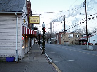
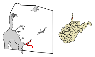
West Hamlin is a town in Lincoln County, West Virginia, United States, along the Guyandotte River. The population was 519 at the 2020 census, and is now down to 509, according to the 2021 census. West Hamlin is a part of the Huntington-Ashland, WV-KY-OH, Metropolitan Statistical Area (MSA). West Hamlin is west of the county seat at Hamlin, hence the name.

<span class="mw-page-title-main">Man, West Virginia</span> Town in West Virginia, United States

Man is a town in Logan County, West Virginia, United States. The population was 772 at the 2020 census. The town is located along the Guyandotte River at the mouth of Buffalo Creek, which was the site of the 1972 Buffalo Creek Flood following a dam collapse. The name of the town reportedly derives from the last syllable of the surname of Ulysses Hinchman, who was a member of the House of Delegates from Logan County between 1866 and 1869.

<span class="mw-page-title-main">New Haven, West Virginia</span> Town in West Virginia, United States

New Haven is a town in Mason County, West Virginia, United States, along the Ohio River. The population was 1,485 at the 2020 census. It is part of the Point Pleasant, WV–OH Micropolitan Statistical Area.

<span class="mw-page-title-main">Northfork, West Virginia</span> Town in West Virginia, United States

Northfork is a town in McDowell County, West Virginia, United States, located on U.S. Route 52 between Welch and Bluefield.

<span class="mw-page-title-main">Athens, West Virginia</span> Town in West Virginia, United States

Athens is a town in Mercer County, West Virginia, United States. The population was 944 at the 2020 census. It is part of the Bluefield, WV-VA micropolitan area which has a population of 107,578. Athens is the home of Concord University.

<span class="mw-page-title-main">Peterstown, West Virginia</span> Town in West Virginia, United States

Peterstown is a town in Monroe County, West Virginia, United States. The population was 456 at the 2020 census.

<span class="mw-page-title-main">Triadelphia, West Virginia</span> Town in West Virginia, United States

Triadelphia is a town in Ohio County, West Virginia, United States. It is part of the Wheeling, West Virginia Metropolitan Statistical Area. The population was 669 at the 2020 census.

<span class="mw-page-title-main">Mill Creek, West Virginia</span> Town in West Virginia, United States

Mill Creek is a town in Randolph County, West Virginia, United States, along the Tygart Valley River. The population was 563 at the 2020 census.

<span class="mw-page-title-main">Reedy, West Virginia</span> Town in West Virginia, United States

Reedy is a town in Roane County, West Virginia, United States. The population was 152 at the 2020 census.

<span class="mw-page-title-main">Flemington, West Virginia</span> Town in West Virginia, United States

Flemington is a town in Taylor County, West Virginia, United States. The population was 311 at the 2020 census. Flemington was incorporated in 1922 by the West Virginia Circuit Court, and named for James Fleming, an early settler in the area originally from Hampshire County.

<span class="mw-page-title-main">New Martinsville, West Virginia</span> City in West Virginia, United States

New Martinsville is a city in and the county seat of Wetzel County, West Virginia, United States, along the Ohio River. The population was 5,186 at the 2020 census.

<span class="mw-page-title-main">Smithers, West Virginia</span> Place in West Virginia, United States

Smithers is a city in Fayette and Kanawha counties in the U.S. state of West Virginia. Located along the Kanawha River, it lies almost entirely in Fayette County. The population was 751 at the 2020 census. The city most likely takes its name from Smithers Creek. The small river city is noted for having a rich cultural history related to both its coal mining and Italian-American heritages.

References

  1. "2019 U.S. Gazetteer Files". United States Census Bureau. Retrieved August 7, 2020.
  2. 1 2 3 4 "City and Town Population Totals: 2020-2021". Census.gov. US Census Bureau. Retrieved July 2, 2022.
  3. 1 2 "U.S. Census website". United States Census Bureau . Retrieved January 31, 2008.
  4. "US Board on Geographic Names". United States Geological Survey. October 25, 2007. Retrieved January 31, 2008.
  5. Kenny, Hamill (1945). West Virginia Place Names: Their Origin and Meaning, Including the Nomenclature of the Streams and Mountains. Piedmont, WV: The Place Name Press. p. 387.
  6. "About Us". local.wv.gov. Retrieved August 9, 2023.
  7. "About Us". local.wv.gov. Retrieved August 9, 2023.
  8. "National Register Information System". National Register of Historic Places . National Park Service. July 9, 2010.
  9. "US Gazetteer files: 2010, 2000, and 1990". United States Census Bureau. February 12, 2011. Retrieved April 23, 2011.
  10. "US Gazetteer files 2010". United States Census Bureau. Archived from the original on July 2, 2012. Retrieved January 24, 2013.
  11. "Census of Population and Housing". Census.gov. Retrieved June 4, 2015.
  12. "U.S. Census website". United States Census Bureau . Retrieved January 24, 2013.
  13. WRITER, Kailee E. Gallahan STAFF. "New Lost Creek Elementary School floor plan, details discussed Thursday". WV News. Retrieved September 15, 2021.