Hinton, West Virginia | |
---|---|
Motto(s): Where friends and rivers meet | |
Coordinates: 37°40′25″N80°53′20″W / 37.67361°N 80.88889°W | |
Country | United States |
State | West Virginia |
County | Summers |
Government | |
• Mayor | Jack L Scott |
• City Manager | Cris Meadows |
Area | |
• Total | 3.03 sq mi (7.85 km2) |
• Land | 2.23 sq mi (5.78 km2) |
• Water | 0.80 sq mi (2.07 km2) |
Elevation | 1,463 ft (446 m) |
Population | |
• Total | 2,266 |
• Estimate (2021) [2] | 2,243 |
• Density | 1,055.53/sq mi (407.60/km2) |
Time zone | UTC-5 (Eastern (EST)) |
• Summer (DST) | UTC-4 (EDT) |
ZIP code | 25951 |
Area code | 304 |
FIPS code | 54-37636 [3] |
GNIS feature ID | 1551458 [4] |
Website | hintonwva.com |
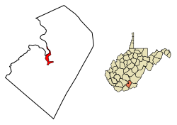
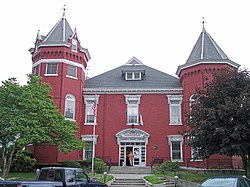
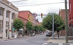
Hinton is a city in and the county seat of Summers County, West Virginia, United States. [5] The population was 2,266 at the 2020 census. [2] Hinton was established in 1873 and chartered in 1897. Hinton was named after John "Jack" Hinton, the original owner of the town site. [6] Much of Hinton's downtown was placed on the National Register of Historic Places in 1984. In 1994, part of Paramount's film Lassie was shot in Hinton. [7] In the 1990s, Hinton's downtown experienced economic decline after a hospital moved away and Interstate 64 bypassed the town. [8] In 2007, Hinton native and business owner Ken Allman founded MountainPlex Properties, which since then has worked to preserve and revitalize the Hinton Historic District. [9] [10] [11]
Hinton is situated along the New River just north of its confluence with the Greenbrier River. Bluestone Lake is located near Hinton. The city is about 28 miles from Beckley and 90 miles from Charleston. According to the United States Census Bureau, the city has a total area of 3.03 square miles (7.85 km2), of which 2.22 square miles (5.75 km2) is land and 0.81 square miles (2.10 km2) is water. [12]
The climate in this area has mild differences between highs and lows, and there is adequate rainfall year-round. According to the Köppen Climate Classification system, Hinton has a marine west coast climate, abbreviated "Cfb" on climate maps. [13]
Census | Pop. | Note | %± |
---|---|---|---|
1880 | 879 | — | |
1890 | 2,570 | 192.4% | |
1900 | 3,763 | 46.4% | |
1910 | 3,656 | −2.8% | |
1920 | 3,912 | 7.0% | |
1930 | 6,654 | 70.1% | |
1940 | 5,815 | −12.6% | |
1950 | 5,780 | −0.6% | |
1960 | 5,197 | −10.1% | |
1970 | 4,503 | −13.4% | |
1980 | 4,428 | −1.7% | |
1990 | 3,433 | −22.5% | |
2000 | 2,880 | −16.1% | |
2010 | 2,676 | −7.1% | |
2020 | 2,266 | −15.3% | |
2021 (est.) | 2,243 | [2] | −1.0% |
U.S. Decennial Census [14] |
As of the census [15] of 2010, there were 2,676 people, 1,276 households, and 676 families living in the city. The population density was 1,205.4 inhabitants per square mile (465.4/km2). There were 1,604 housing units at an average density of 722.5 per square mile (279.0/km2). The racial makeup of the city was 92.0% White, 5.3% African American, 0.1% Native American, 0.4% Asian, and 2.0% from two or more races. Hispanic or Latino of any race were 0.5% of the population.
There were 1,276 households, of which 21.9% had children under the age of 18 living with them, 34.8% were married couples living together, 13.2% had a female householder with no husband present, 4.9% had a male householder with no wife present, and 47.0% were non-families. 42.9% of all households were made up of individuals, and 22% had someone living alone who was 65 years of age or older. The average household size was 2.07 and the average family size was 2.83.
The median age in the city was 46 years. 19.4% of residents were under the age of 18; 6.9% were between the ages of 18 and 24; 22.3% were from 25 to 44; 28.2% were from 45 to 64; and 23.2% were 65 years of age or older. The gender makeup of the city was 46.6% male and 53.4% female.
As of the census [3] of 2000, there were 2,880 people, 1,357 households, and 755 families living in the city. The population density was 1,244.5 people per square mile (481.4/km2). There were 1,595 housing units at an average density of 689.2 per square mile (266.6/km2). The racial makeup of the city was 92.43% White, 5.49% African American, 0.52% Native American, 0.21% Asian, 0.10% Pacific Islander, 0.07% from other races, and 1.18% from two or more races. Hispanic or Latino of any race were 0.73% of the population.
There were 1,357 households, out of which 19.4% had children under the age of 18 living with them, 40.1% were married couples living together, 12.6% had a female householder with no husband present, and 44.3% were non-families. 41.3% of all households were made up of individuals, and 22.7% had someone living alone who was 65 years of age or older. The average household size was 2.10 and the average family size was 2.85.
In the city, the population was spread out, with 19.4% under the age of 18, 7.3% from 18 to 24, 22.8% from 25 to 44, 24.3% from 45 to 64, and 26.2% who were 65 years of age or older. The median age was 45 years. For every 100 females, there were 82.6 males. For every 100 females age 18 and over, there were 79.2 males.
The median income for a household in the city was $20,323, and the median income for a family was $25,769. Males had a median income of $23,654 versus $25,543 for females. The per capita income for the city was $13,909. About 22.6% of families and 27.6% of the population were below the poverty line, including 35.1% of those under age 18 and 15.2% of those age 65 or over.
There are several museums in Hinton, including the Veterans Memorial Museum, the Hinton Railroad Museum, [16] and King's Civil War Museum. [17] City of Hinton Parks and recreation department has a water park complete with a water slide and swimming pool. [18]
Hinton's economy largely relies on transportation, information technology, and tourism. [19] Major employers in Hinton include CSX Transportation, Summers County Schools, and ManTech International. Headquartered in Hinton, PracticeLink is the largest job bank for physicians in the United States. [20]
Amtrak provides national passenger rail service to Hinton via the Cardinal route, which stops at Hinton Station. CSX owns the rail line through Hinton, which is the mainline of the former Chesapeake and Ohio Railway. Hinton was a major terminal for the C&O. [21]
Burnsville is a town in Braxton County, West Virginia, United States, at the confluence of the Little Kanawha River and Saltlick Creek. The population was 401 at the 2020 census. Burnsville was incorporated in 1902 by the Circuit Court and named for Captain John Burns who operated the first sawmill in that section of the state and who established the town shortly after the close of the American Civil War. It was named "All West Virginia City" in 1976.
Follansbee is a city in Brooke County, West Virginia, United States, located along the Ohio River. The population was 2,853 at the 2020 census, a decrease from 2,986 at the 2010 census. It is part of the Weirton–Steubenville metropolitan area. The city was named after the Follansbee brothers, the proprietors of a local steel mill.
Petersburg is a city in Grant County, West Virginia, United States. The population was 2,251 at the 2020 census. It is the county seat of Grant County.
Quinwood is a town and former coal town in Greenbrier County, West Virginia, United States. The population was 220 at the 2020 census.
White Sulphur Springs is a city in Greenbrier County in southeastern West Virginia, United States. The population was 2,231 at the 2020 census. The city emblem consists of five dandelion flowers and the citizens celebrate spring with an annual Dandelion Festival.
Glen Dale is a city in Marshall County, West Virginia, United States, along the Ohio River. It is part of the Wheeling, West Virginia Metropolitan Statistical Area. The population was 1,514 at the 2020 census. Glen Dale was incorporated in 1924. It is in the northwest part of the county, which is above the Mason–Dixon line and forms the base of the Northern Panhandle of West Virginia.
McMechen is a city in Marshall County, West Virginia, United States, situated along the Ohio River. It is part of the Wheeling, West Virginia Metropolitan Statistical Area. The population was 1,714 at the 2020 census.
Henderson is an unincorporated community and former town in Mason County, West Virginia, United States, at the confluence of the Ohio and Kanawha Rivers. The population was 231 at the 2020 census. It is part of the Point Pleasant, WV–OH Micropolitan Statistical Area. The town was incorporated in 1893 and named for Samuel Bruce Henderson, who owned the townsite at the time. The town was unincorporated following a public hearing on August 11, 2022.
New Haven is a town in Mason County, West Virginia, United States, along the Ohio River. The population was 1,485 at the 2020 census. It is part of the Point Pleasant, WV–OH Micropolitan Statistical Area.
Athens is a town in Mercer County, West Virginia, United States. The population was 944 at the 2020 census. It is part of the Bluefield, WV-VA micropolitan area which has a population of 107,578. Athens is the home of Concord University.
Matoaka is a census-designated place in Mercer County, West Virginia, United States. The population was 173 at the 2020 census. It is part of the Bluefield, WV-VA micropolitan area which has a population of 100,093. This town is named for Chief Powhatan's daughter Matoaka who was better known by her nickname "Pocahontas". Matoaka became an unincorporated town when it voted to dissolve its charter in May 2018.
Granville is a town in Monongalia County, West Virginia, United States. The population was 1,355 at the 2020 census. It is included in the Morgantown metropolitan area.
Albright is a town in central Preston County, West Virginia, United States, along the Cheat River. The population was 260 at the 2020 census. A former coal town, it is part of the Morgantown metropolitan area.
Rowlesburg is a town in southern Preston County, West Virginia, United States, along the Cheat River. The population was 438 at the 2020 census. It is part of the Morgantown metropolitan area. A former railroad town, it is home to the Downtown Rowlesburg Historic District, and was the site of action during the American Civil War.
Terra Alta is a town in eastern Preston County, West Virginia, United States. The population was 1,415 at the 2020 census. It is part of the Morgantown metropolitan area.
Harman is a town in Randolph County, West Virginia, United States. The population was 96 at the 2020 census.
Cairo is a town in Ritchie County, West Virginia, United States, along West Virginia Route 31, the North Fork of the Hughes River, and the North Bend Rail Trail. The population was 174 at the 2020 census.
Pennsboro is a city in Ritchie County, West Virginia, United States. The population was 1,050 at the 2020 census. The city is located at the junction of U.S. Route 50 and West Virginia Route 74; the North Bend Rail Trail also passes through the city.
New Martinsville is a city in and the county seat of Wetzel County, West Virginia, United States, along the Ohio River. The population was 5,186 at the 2020 census.
Boaz is a census-designated place (CDP) in Wood County, West Virginia, United States. It is part of the Parkersburg-Marietta-Vienna, WV-OH Metropolitan Statistical Area. As of the 2020 census, the CDP population was 1,321.