Logan, West Virginia

Last updated

Logan, West Virginia
Logan-downtown-from-hospital-wv.jpg
Logan
Seal of Logan, West Virginia.svg
Logan County West Virginia Incorporated and Unincorporated areas Logan Highlighted.svg
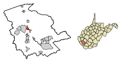
Location of Logan in Logan County, West Virginia.
Coordinates: 37°50′54″N81°59′16″W / 37.84833°N 81.98778°W / 37.84833; -81.98778
Country United States
State West Virginia
County Logan
Government
  MayorSerafino Nolletti
Area
[1]
  Total1.23 sq mi (3.20 km2)
  Land1.15 sq mi (2.97 km2)
  Water0.09 sq mi (0.22 km2)
Elevation
679 ft (207 m)
Population
 (2020) [2]
  Total1,438
  Estimate 
(2021) [2]
1,400
  Density1,280.49/sq mi (494.59/km2)
Time zone UTC-5 (Eastern (EST))
  Summer (DST) UTC-4 (EDT)
ZIP code
25601
Area code(s) 304 & 681
FIPS code 54-48148 [3]
GNIS feature ID1542310 [4]

Logan is a city in Logan County, West Virginia, United States, along the Guyandotte River. The population was 1,438 at the 2020 census. [2] It is the county seat of Logan County. [5]

Contents

History

What is now Logan was initially called "Islands of the Guyandot" by explorers who identified the site in the 1780s. [6] In 1827, a town was laid out at the site to serve as a county seat for Logan County, which had been established in 1824. The city was initially known as "Lawsonsville" after Anthony Lawson, an early merchant, but was shortened to "Lawnsville." In the early 1850s, Thomas Dunn English, a poet and future congressman, led efforts to reorganize the town. [7] When the town incorporated in 1853, it was renamed "Aracoma" after the Shawnee chief Cornstalk's daughter, [7] who had been killed by settlers in the area in 1780. [8] The city was renamed "Logan" in 1907 after the Mingo leader, Chief Logan. [6]

Logan in 1974 MAIN STREET OF LOGAN, WEST VIRGINIA, SHOWING A NARROW STREET WITH PARKING ON ONLY ONE SIDE WHICH IS TYPICAL IN MANY... - NARA - 556422.jpg
Logan in 1974

Logan grew continuously during the late 19th and early 20th centuries as a hub of the regional coal industry. At its height in 1940, the city had a population of over 5,000, and was home to numerous businesses, including furniture stores, hotels, banks, and car dealerships. Logan began to decline following World War II, due in large part to the increased mechanization of the coal industry. [6]

The Chafin House, was listed on the National Register of Historic Places in 1994. [9] Logan was home to the Logan Indians, a minor league baseball team, from 1937 to 1942.

Geography

Logan is located at the confluence of the Guyandotte River and Island Creek. [10]

According to the United States Census Bureau, the city has a total area of 1.24 square miles (3.21 km2), of which 1.15 square miles (2.98 km2) is land and 0.09 square miles (0.23 km2) is water. [11]

Climate

Climate data for Logan, West Virginia (1991–2020 normals, extremes 1901–present)
MonthJanFebMarAprMayJunJulAugSepOctNovDecYear
Record high °F (°C)81
(27)
83
(28)
91
(33)
95
(35)
99
(37)
105
(41)
104
(40)
102
(39)
103
(39)
97
(36)
87
(31)
79
(26)
105
(41)
Mean daily maximum °F (°C)44.5
(6.9)
49.3
(9.6)
58.9
(14.9)
71.2
(21.8)
78.7
(25.9)
85.8
(29.9)
88.6
(31.4)
87.5
(30.8)
81.9
(27.7)
70.2
(21.2)
58.4
(14.7)
48.0
(8.9)
68.6
(20.3)
Daily mean °F (°C)35.6
(2.0)
39.2
(4.0)
46.8
(8.2)
57.5
(14.2)
66.3
(19.1)
74.2
(23.4)
77.8
(25.4)
76.7
(24.8)
70.4
(21.3)
58.5
(14.7)
47.2
(8.4)
39.3
(4.1)
57.5
(14.2)
Mean daily minimum °F (°C)26.6
(−3.0)
29.0
(−1.7)
34.8
(1.6)
43.8
(6.6)
54.0
(12.2)
62.6
(17.0)
66.9
(19.4)
65.8
(18.8)
59.0
(15.0)
46.7
(8.2)
36.0
(2.2)
30.7
(−0.7)
46.3
(7.9)
Record low °F (°C)−15
(−26)
−11
(−24)
−2
(−19)
19
(−7)
29
(−2)
35
(2)
45
(7)
42
(6)
34
(1)
18
(−8)
7
(−14)
−8
(−22)
−15
(−26)
Average precipitation inches (mm)3.45
(88)
3.45
(88)
4.33
(110)
4.36
(111)
5.33
(135)
4.89
(124)
5.88
(149)
3.94
(100)
3.34
(85)
3.17
(81)
2.94
(75)
4.16
(106)
49.24
(1,251)
Average precipitation days (≥ 0.01 in)14.713.414.113.114.513.613.710.510.411.010.614.6154.2
Source: NOAA [12] [13]

Demographics

Historical population
CensusPop.Note
1900 444
1910 1,640269.4%
1920 2,99882.8%
1930 4,39646.6%
1940 5,16617.5%
1950 5,079−1.7%
1960 4,185−17.6%
1970 3,311−20.9%
1980 3,029−8.5%
1990 2,206−27.2%
2000 1,630−26.1%
2010 1,7799.1%
2020 1,438−19.2%
2021 (est.)1,400 [2] −2.6%
U.S. Decennial Census [14]

2010 census

As of the census [15] of 2010, there were 1,779 people, 808 households, and 469 families living in the city. The population density was 1,547.0 inhabitants per square mile (597.3/km2). There were 1,016 housing units at an average density of 883.5 units per square mile (341.1 units/km2). The racial makeup of the city was 91.6% White, 5.2% African American, 0.3% Native American, 0.7% Asian, 0.2% from other races, and 2.0% from two or more races. Hispanic or Latino of any race were 2.0% of the population.

There were 808 households, of which 26.4% had children under the age of 18 living with them, 36.8% were married couples living together, 15.7% had a female householder with no husband present, 5.6% had a male householder with no wife present, and 42.0% were non-families. 37.0% of all households were made up of individuals, and 13.6% had someone living alone who was 65 years of age or older. The average household size was 2.20 and the average family size was 2.85.

The median age in the city was 40.4 years. 20.2% of residents were under the age of 18; 9.4% were between the ages of 18 and 24; 26.3% were from 25 to 44; 28.1% were from 45 to 64; and 15.8% were 65 years of age or older. The gender makeup of the city was 47.4% male and 52.6% female.

2000 census

As of the census [3] of 2000, there were 1,630 people, 750 households, and 423 families living in the city. The population density was 1,403.5 people per square mile (541.9 people/km2). There were 965 housing units at an average density of 830.9 units per square mile (320.8 units/km2). The racial makeup of the city was 92.52% White, 4.79% African American, 0.31% Native American, 0.61% Asian, 0.06% from other races, and 1.72% from two or more races. Hispanic or Latino of any race were 0.80% of the population.

There were 750 households, out of which 20.9% had children under the age of 18 living with them, 38.3% were married couples living together, 13.2% had a female householder with no husband present, and 43.6% were non-families. 40.7% of all households were made up of individuals, and 18.9% had someone living alone who was 65 years of age or older. The average household size was 2.08 and the average family size was 2.78.

In the city, the population was spread out, with 16.8% under the age of 18, 8.5% from 18 to 24, 26.2% from 25 to 44, 26.7% from 45 to 64, and 21.8% who were 65 years of age or older. The median age was 44 years. For every 100 females, there were 82.3 males. For every 100 females age 18 and over, there were 79.1 males.

The median income for a household in the city was $22,623, and the median income for a family was $26,354. Males had a median income of $26,350 versus $19,167 for females. The per capita income for the city was $15,913. About 18.2% of families and 20.7% of the population were below the poverty line, including 29.0% of those under age 18 and 9.7% of those age 65 or over.

Logan, West Virginia (2014).jpg
Logan in 2014

Education

Logan is served by Logan High School, grades 9–12. [16] [17]

Media

Notable people

See also

Related Research Articles

<span class="mw-page-title-main">Mingo County, West Virginia</span> County in West Virginia, United States

Mingo County is a county in the U.S. state of West Virginia. As of the 2020 census, the population was 23,568. Its county seat and largest city is Williamson. Created in 1895, Mingo is West Virginia's newest county, named for the historic Iroquoian Mingo people.

<span class="mw-page-title-main">Hancock County, West Virginia</span> County in West Virginia, United States

Hancock County is a county in the U.S. state of West Virginia. As of the 2020 census, the population was 29,095. Its county seat is New Cumberland and its largest city is Weirton. The county was created from Brooke County in 1848 and named for John Hancock, first signer of the Declaration of Independence. Located at the tip of the state's Northern Panhandle, Hancock County is the northernmost point in both West Virginia and, by some definitions, the Southern United States. Hancock County is part of the Weirton-Steubenville, WV-OH Metropolitan Statistical Area, which is also included in the Pittsburgh-New Castle-Weirton, PA-WV-OH Combined Statistical Area.

<span class="mw-page-title-main">Boone County, West Virginia</span> County in West Virginia, United States

Boone County is a county in the U.S. state of West Virginia. As of the 2020 census, the population was 21,809. Its county seat is Madison. Boone County is part of the Charleston, WV Metropolitan Statistical Area. Leading industries and chief agricultural products in Boone County include coal, lumber, natural gas, tobacco, and strawberries.

<span class="mw-page-title-main">Hedgesville, West Virginia</span> Town in West Virginia, United States

Hedgesville is a town in Berkeley County, West Virginia, United States, in the state's Eastern Panhandle region. The population was 318 at the 2010 census. The town sits on WV 9, roughly 13 miles east of Berkeley Springs. In addition to its legal definition, Hedgesville has come to be the common name for the large and sparsely inhabited area of West Virginia's Eastern Panhandle bordered by the Potomac River to the North and East, a southern border defined roughly by an imaginary line from the city of Martinsburg to the tip of Virginia, and Berkeley Springs to the West.

<span class="mw-page-title-main">Danville, West Virginia</span> Town in West Virginia, United States

Danville is a town in Boone County, West Virginia, United States. The population was 660 at the 2020 census. Danville was incorporated in 1911 and named for Dan Rock, the town's first postmaster. Danville was formerly known as Newport and Red House.

<span class="mw-page-title-main">Madison, West Virginia</span> City in West Virginia, United States

Madison is a city and former coal town in Boone County, West Virginia, United States. The population was 2,911 at the 2020 census. It is the county seat of Boone County.

<span class="mw-page-title-main">Oak Hill, West Virginia</span> City in West Virginia, United States

Oak Hill is a city in Fayette County, West Virginia, United States. The population was 8,179 at the 2020 census. It is part of the Beckley metropolitan area.

<span class="mw-page-title-main">West Hamlin, West Virginia</span> Town in West Virginia, United States

West Hamlin is a town in Lincoln County, West Virginia, United States, along the Guyandotte River. The population was 519 at the 2020 census, and is now down to 509, according to the 2021 census. West Hamlin is a part of the Huntington-Ashland, WV-KY-OH, Metropolitan Statistical Area (MSA). West Hamlin is west of the county seat at Hamlin, hence the name.

<span class="mw-page-title-main">Chapmanville, West Virginia</span> Town in West Virginia, United States

Chapmanville is a town in Logan County, West Virginia, United States. The population was 1,025 at the 2020 census. Chapmanville is named for Ned Chapman, an early settler who operated a store and post office. It was incorporated in 1947.

<span class="mw-page-title-main">Holden, West Virginia</span> Census-designated place in West Virginia, United States

Holden is a census-designated place (CDP) in Logan County, West Virginia, United States. The population was 876 at the 2010 census, down from 1,105 in 2000. The CDP contains the unincorporated communities of Holden, Beebe, Frogtown, Sycamore, Diamond, and Davis, all in the valley of Copperas Mine Fork.

<span class="mw-page-title-main">Mallory, West Virginia</span> Census-designated place in West Virginia, United States

Mallory is a census-designated place (CDP) in Logan County, West Virginia, United States. The population was 1,654 at the 2010 census. The CDP contains the unincorporated communities, from west to east, of Huff Junction, Mallory, Davin, Mineral City, Claypool, Combs Addition, and Gillman Bottom.

<span class="mw-page-title-main">Man, West Virginia</span> Town in West Virginia, United States

Man is a town in Logan County, West Virginia, United States. The population was 772 at the 2020 census. The town is located along the Guyandotte River at the mouth of Buffalo Creek, which was the site of the 1972 Buffalo Creek Flood following a dam collapse. The name of the town reportedly derives from the last syllable of the surname of Ulysses Hinchman, who was a member of the House of Delegates from Logan County between 1866 and 1869.

<span class="mw-page-title-main">Mitchell Heights, West Virginia</span> Town in West Virginia, United States

Mitchell Heights is a town in Logan County, West Virginia, United States. The population was 315 at the 2020 census. The town was named for an early farm on which it was established.

<span class="mw-page-title-main">Switzer, West Virginia</span> Census-designated place in West Virginia, United States

Switzer is an unincorporated community and census-designated place (CDP) in Logan County, West Virginia, United States. The CDP includes the neighboring unincorporated community of Micco. The total CDP population was 595 at the 2010 census.

<span class="mw-page-title-main">West Logan, West Virginia</span> Town in West Virginia, United States

West Logan is a town along the Guyandotte River in Logan County, West Virginia, United States. The population was 400 at the 2020 census. For unknown reasons, some sources report West Logan to lay west of the county seat at Logan, attributing to this fact the name.

<span class="mw-page-title-main">Blacksville, West Virginia</span> Town in West Virginia

Blacksville is an Incorporated Town in Monongalia County, West Virginia, United States. The population was 118 at the 2020 census. It is included in the Morgantown, West Virginia Metropolitan Statistical Area.

<span class="mw-page-title-main">Durbin, West Virginia</span> Town in West Virginia, United States

Durbin is a town in Pocahontas County, West Virginia, United States. The population was 235 at the 2020 census.

<span class="mw-page-title-main">Pennsboro, West Virginia</span> City in West Virginia, United States

Pennsboro is a city in Ritchie County, West Virginia, United States. The population was 1,050 at the 2020 census. The city is located at the junction of U.S. Route 50 and West Virginia Route 74; the North Bend Rail Trail also passes through the city.

<span class="mw-page-title-main">Hinton, West Virginia</span> City in West Virginia, United States

Hinton is a city in and the county seat of Summers County, West Virginia, United States. The population was 2,266 at the 2020 census. Hinton was established in 1873 and chartered in 1897. Hinton was named after John "Jack" Hinton, the original owner of the town site. Much of Hinton's downtown was placed on the National Register of Historic Places in 1984. In 1994, part of Paramount's film Lassie was shot in Hinton. In the 1990s, Hinton's downtown experienced economic decline after a hospital moved away and Interstate 64 bypassed the town. In 2007, Hinton native and business owner Ken Allman founded MountainPlex Properties, which since then has worked to preserve and revitalize the Hinton Historic District.

<span class="mw-page-title-main">Pineville, West Virginia</span> Town in West Virginia, United States

Pineville is a town in and the county seat of Wyoming County, West Virginia, United States, situated along the Guyandotte River. The population was 648 at the 2020 census.

References

  1. "2019 U.S. Gazetteer Files". United States Census Bureau. Retrieved August 7, 2020.
  2. 1 2 3 4 "City and Town Population Totals: 2020-2021". Census.gov. US Census Bureau. Retrieved July 3, 2022.
  3. 1 2 "U.S. Census website". United States Census Bureau . Retrieved January 31, 2008.
  4. "US Board on Geographic Names". United States Geological Survey. October 25, 2007. Retrieved January 31, 2008.
  5. "Find a County". National Association of Counties. Retrieved June 7, 2011.
  6. 1 2 3 Robert Y. Spence, "Logan," West Virginia Encyclopedia, 2010.
  7. 1 2 Robert Y. Spence, "Logan County," West Virginia Encyclopedia, 2015.
  8. "Logan," West Virginia Division of Archives and History historical marker, 2002.
  9. "National Register Information System". National Register of Historic Places . National Park Service. March 13, 2009.
  10. West Virginia Atlas & Gazetteer. Yarmouth, Me.: DeLorme. 1997. p. 51. ISBN   0-89933-246-3.
  11. "US Gazetteer files 2010". United States Census Bureau. Archived from the original on July 2, 2012. Retrieved January 24, 2013.
  12. "NowData - NOAA Online Weather Data". National Oceanic and Atmospheric Administration. Retrieved June 13, 2021.
  13. "Station: Logan, WV". U.S. Climate Normals 2020: U.S. Monthly Climate Normals (1991-2020). National Oceanic and Atmospheric Administration. Retrieved June 13, 2021.
  14. "Census of Population and Housing". Census.gov. Retrieved June 4, 2015.
  15. "U.S. Census website". United States Census Bureau . Retrieved January 24, 2013.
  16. "Logan Senior High School". Usnews.com. Retrieved February 2, 2022.
  17. "Home : Chapmanville Regional High School". Crhs.logan.k12.wv.us. Retrieved February 2, 2022.
  18. "Logan Banner to change publication schedule starting next month". Loganbanner.com. Retrieved October 8, 2019.
  19. Omar, Aref (October 28, 2007). "Get cool with magic". New Straits Times . Media Prima. Archived from the original on November 4, 2012. Retrieved November 25, 2012.
  20. "Shane Burton". NFL.com. Retrieved July 16, 2014.